
Epic time-lapse of supercell storm cloud formation
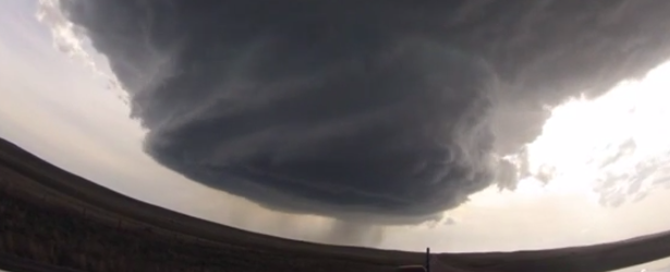
Image credit: Basehunters
A group of stormchasers called "Basehunters" have released two awesome videos of supercell cloud storms formed in northeast Wyoming (U.S.) over the last two days. Supercell storm clouds are rare, beautiful and extremely dangerous.
The first video was taken on May 18, 2014 while the group was driving from Wright to Newcastle. It went viral on the first day and by mid May 20 (UTC time), it got more than 3 million views. The video captures both formation and dissipation of the supercell.

May 18, 2014. Video courtesy of Basehunters
This next video was taken on May 19 while driving from Bridgeport to Sidney.

May 19, 2014. Video courtesy of Basehunters
A supercell is a thunderstorm that is characterized by the presence of a mesocyclone: a deep, persistently rotating updraft. They can occur anywhere in the world under the right weather conditions but are most common in the Great Plains of the United States in an area known as Tornado Alley and in the plains of Argentina, Uruguay and southern Brazil.
Of the four classifications of thunderstorms (supercell, squall line, multi-cell, and single-cell), supercells are the overall least common and have the potential to be the most severe.

Teo Blašković founded The Watchers in 2011 and edited it until 2026, covering seismic and volcanic activity, extreme weather, space weather and near-Earth objects. Articles on this page are his archive.
Published in the last 24 hours
- High Risk of excessive rainfall covers Florida’s Space Coast as St. Johns River near Cocoa reaches 5.67 m
- Asteroid 2026 WJ to pass Earth at 1.7 lunar distances at 04:20 UTC on November 22, with 2026 WD following at 4.4 lunar distances on November 23
- Cyclone Akvan crossed the north Andhra Pradesh and south Odisha coasts close to Gopalpur on November 20 with 70-80 km/h winds gusting to 90, and has weakened into a deep depression
- A broad low over southeastern Florida and the northwestern Bahamas has a 30 percent chance of subtropical or tropical development within 48 hours and a 50 percent chance within 7 days, the National Hurricane Center says
