
Underwater eruption of Mount Hobal – Iliwerung volcano, Indonesia
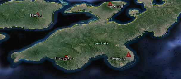
Image credit: Landsat. Data: SIO, NOAA, US Navy, NGA, GEBCO. Copyright: 2013 TerraMetrics/Google. Volcano markups: Smithsonian Institution - Global Volcanism Program
A submarine eruption at Mount Hobal, underwater flank of Iliwerung volcano, Indonesia, has occurred on August 19/20, 2013. VSI raised the alert level of Iliwerung volcano from 1 (normal) to 2 (watch) following increased seismic and visual activity from Hobal.
Iliwerung volcano forms a peninsula on the south coast of Lembata island, formerly Lomblen. Mount Hobal (Gunung Hobal) is located about 800 m from the coast.
A total of 181 earthquakes were reported at Hobal flank on August 19, 2013.
The latest bulletin of VSI issued on August 20 describes that the water around Hobal has recently shown significant color changes to yellow, intense bubbling and white steam plumes rising up to about 1000-2000 m from 07:14 am local time on August 20, 2013 (22:14 UTC on August 19, 2013). Half an hour later, from 07:46, glow even began to be visible.
Strangely, no plume or other strong evidence of an eruption have been available so far from satellite data, except tiny spots visible on the latest images of the area which could be floating pumice (VD).
VSI points out that there is an elevated risk of tsunamis associated with potential more eruptive activity, and recommends not to approach the coast within 30 m from the sea. Visitors, fishermen and tourists are not allowed to engage in any activity within a radius of 2 km from the center of activity.
Potential hazards from Mount Hobal eruption are a burst of incandescent material, dense ash, toxic gas and big waves.
- In GVP's Iliwerung eruption history database, Mount Hobal eruption is first mentioned on December 5, 1973, then on March 8, 1976; August 17, 1983; September 15, 1993; and May 22, 1999.
- In the known history of eruptions Iliwerung has erupted 17 times, the first known eruption was in 1870 and the last eruption in May 22, 1999.
Latest GVP's weekly volcano activity report entry for Iliwerung volcano was in the week of October 31 – November 6, 2001:
An increase in tectonic earthquakes around Iliwerung during October 17 – 26 led VSI to raise the Alert Level from 1 to 2 (on a scale of 1-4). From 2 to 11 earthquakes were felt per day with Modified Mercalli intensities of I-II. Visual and instrumental monitoring did not show a significant change in volcanic activity.
.png)
Major volcanoes of Indonesia. Image credit: USGS. IIwerung location edit: The Watchers
Constructed on the southern rim of the Lerek caldera, Iliwerung forms a prominent south-facing peninsula on Lembata Island. Craters and lava domes have formed along N-S and NW-SE lines on the complex volcano; during historical time vents from the summit to the submarine SE flank have been active.
The Iliwerung summit lava dome was formed during an eruption in 1870. In 1948 Iligripe lava dome grew on the eastern flank at 120 m altitude. Beginning in 1973-74, when three ephemeral islands were formed, submarine eruptions began on the lower SE flank at a vent named Hobal; several other eruptions took place from this vent before the end of the century (GVP).
I'm a dedicated researcher, journalist, and editor at The Watchers. With over 20 years of experience in the media industry, I specialize in hard science news, focusing on extreme weather, seismic and volcanic activity, space weather, and astronomy, including near-Earth objects and planetary defense strategies. You can reach me at teo /at/ watchers.news.
Commenting rules and guidelines
We value the thoughts and opinions of our readers and welcome healthy discussions on our website. In order to maintain a respectful and positive community, we ask that all commenters follow these rules.