
Very strong M 6.7 earthquake hit Santa Cruz Islands
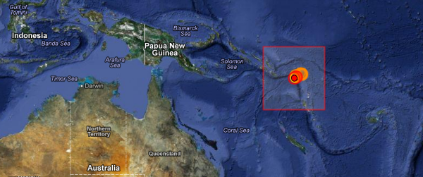
Image credit: EMSC+GoogleMaps
Very strong and shallow earthquake, with preliminary magnitude registered as 6.7 (USGS) hit Santa Cruz Islands on February 01, 2013 at 22:16:35 UTC. The epicenter was located 45 km SW Lata, Solomon Islands and 375 km (233 miles) E (101°) from Kira Kira, at coordinated 11.058°S, 165.313°E and at depth of 10 km (6.2 miles) according to USGS. EMSC reported M 6.2 at depth of only 2 km. There was no tsunami warning issued.

| Magnitude | 6.7 |
|---|---|
| Date-Time |
|
| Location | 10.997°S, 165.403°E |
| Depth | 34.2 km (21.3 miles) |
| Region | SANTA CRUZ ISLANDS |
| Distances |
|
| Location Uncertainty | horizontal +/- 15.7 km (9.8 miles); depth +/- 5 km (3.1 miles) |
| Parameters | NST=266, Nph=269, Dmin=622.3 km, Rmss=1.57 sec, Gp= 29°, M-type=regional moment magnitude (Mw), Version=A |
| Source |
|
| Event ID | usc000ezv6 |
This is the forth M6+ earthquake that struck the area in only 3 days, followed by dozens of M4+ and M5+ earthquakes and the second today. Earlier, M 6.0 hit the area 59 km (36 miles) SW of Lata, Solomon Islands at depth of 9.4 km, followed by (5.8 miles).
UPDATE (February 1, 2013 – 22:56 UTC)
EMSC revised magnitude and their reports now show M 6.7, same as USGS. EMSC also reports different dept, instead of initial 2 km, they are now showing 35km. Both agencies now showing M 6.7 at depth of 35 km.
6.3 — http://earthquake.usgs.gov/earthquakes/shakemap/global/shake/c000ezv6/
5.7 — http://earthquake.usgs.gov/earthquakes/shakemap/global/shake/c000ezw4/
5.6 — http://earthquake.usgs.gov/earthquakes/shakemap/global/shake/c000ezyt/
. . . part of the same swarm?
as long as it is not christchrch new zealand i will be ok