
New Zealand: Vigorous hydrothermal activity at White Island, Tongariro in heightened state of unrest
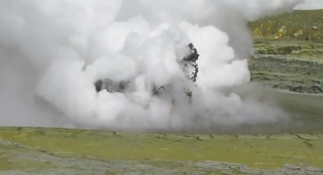
Image credit: Screen capture from GNS Science's video of White Island hydrothermal activity - January 2013.
White Island – Vigorous hydrothermal activity reported
In GeoNet’s Volcanic Alert Bulletin issued on January 22, 2013 GNS Science Volcanologist Brad Scott writes his report after visiting White Island on January 21st to assess the increased level of volcanic unrest:
Observations confirmed that hydrothermal activity in the small ‘hot lake’ has increased. The most common activity is “doming-up” of the lake surface by steam/gas, bringing large amounts of sediment to the surface, often with vivid white steam/gas ‘flashing’ from around the base. Every so often stronger events happened. This activity has been increasing since late 2012 and is now semi-continuous.
The state of unrest at White Island is increasing and future eruptions are possible with little or no warning. The increased level of unrest does mean that there is a hazard to visitors. Past activity indicates that eruptions, such as that which occurred on 5 August 2012, could occur with little or no warning, even when the Alert Level is 1 (volcanic unrest). Caution should be exercised when visiting the island.
“The hydrothermal activity is some of the most vigorous I have seen at White Island for many years. This type of activity usually leads to stronger volcanic activity and is a significant concern”, Brad Scott, GNS Science Volcanologist
White Island drums
Image below show seismic activity over the last 24 hours.
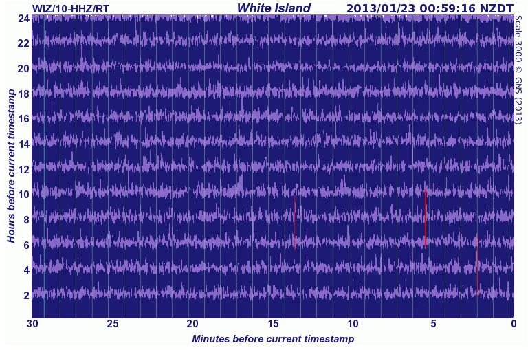 The timestamps shown at the top right of the seismograph drums shown below are the time when these images were last refreshed. Each horizontal line (or trace) represents 30 minutes, each vertical line is spaced 1 minute apart; 24 hours of recording are displayed in total. The most recent signal is drawn at the bottom right hand corner of the drum. Then read the traces from right to left, bottom to top, to get from the most recent to the oldest signals. The trace will appear red if the signals are very large; this means they have been clipped to stop them overwriting too much of the surrounding image. Credit: GNS Science
About White Island
Uninhabited 2 x 2.4 km White Island, one of New Zealand’s most active volcanoes, is the emergent summit of a 16 x 18 km submarine volcano in the Bay of Plenty about 50 km offshore of North Island. The 321-m-high island consists of two overlapping andesitic-to-dacitic stratovolcanoes; the summit crater appears to be breached to the SE because the shoreline corresponds to the level of several notches in the SE crater wall. Volckner Rocks, four sea stacks that are remnants of a lava dome, lie 5 km NNE of White Island.
Intermittent moderate phreatomagmatic and strombolian eruptions have occurred at White Island throughout the short historical period beginning in 1826, but its activity also forms a prominent part of Maori legends. Formation of many new vents during the 19th and 20th centuries has produced rapid changes in crater floor topography. Collapse of the crater wall in 1914 produced a debris avalanche that buried buildings and workers at a sulfur-mining project. (GVP)
***
Volcanic alert level summary – New Zealand
(January 22, 2013)
Table below shows the latest volcanic alert levels. The most active volcanoes are shown first.
| Volcano | Alert Level | Aviation Color Code |
| Tongariro | 1 | Yellow |
| White Island | 1 | Yellow |
| Ruapehu | 1 | Yellow |
| Ngauruhoe | 0 | Green |
| Kermadec Islands | 0 | Green |
| Auckland Volcanic Field | 0 | Green |
| Mayor Island | 0 | Green |
| Northland | 0 | Green |
| Okataina | 0 | Green |
| Taranaki/Egmont | 0 | Green |
| Rotorua | 0 | Green |
| Taupo | 0 | Green |
***
Tongariro in heightened state of unrest
Meanwhile, according to Volcanic Alert Bulletin dated January 14, 2013 Tongariro continues to be in a heightened state of unrest and eruptions could occur with little or no precursors.
GNS Science volcanologists Craig Miller and Brad Scott wrote:
Te Maari craters at Mount Tongariro, the site of eruptions in August and November 2012, continue to be active with continuous emissions of steam and volcanic gas. Emission of a steam and gas plume has been a continuous feature of the mountain since the August 2012 eruption. The gas is coming from a large fumarole and crack in a cliff just east of the Upper Te Maari crater. The main Upper Te Maari crater is also discharging gas but at a lesser rate. Fumaroles associated with a fissure farther to the east have declined and are no longer easily visible.
Volcanic gas from the plume may continue to be smelt in areas downwind of the volcano. GNS Science volcanologists will be making gas measurements at the next available opportunity to compare to those made at the end of December 2012, however recent visual observations show that the emissions are on-going and sustained. Observers of the mountain may notice that emissions appear to be stronger on some days than others, which is due to a combination of variability in the degassing rate and atmospheric conditions which make the plume more visible on some days. GNS head volcanologist Gill Jolly said “gas and steam emissions from the volcano will continue to be a feature of the mountain for several years to come.”
Aerial observations at the end of 2012 showed that a large amount of material had in-filled the Upper Te Maari crater as part of the 21 November 2012 eruption, however the main shape of the crater had not changed.
Seismicity has remained relatively low with no earthquakes yet recorded beneath the mountain in 2013.
Tongariro continues to be in a heightened state of unrest and eruptions could occur with little or no precursors.
The Volcano Alert Level remains at 1 and the Aviation Colour Code remains at Yellow.
Tongariro drums
Image below show seismic activity over the last 24 hours.
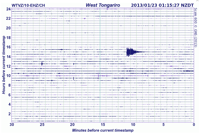 The timestamps shown at the top right of the seismograph drums shown below are the time when these images were last refreshed. Each horizontal line (or trace) represents 30 minutes, each vertical line is spaced 1 minute apart; 24 hours of recording are displayed in total. The most recent signal is drawn at the bottom right hand corner of the drum. Then read the traces from right to left, bottom to top, to get from the most recent to the oldest signals. The trace will appear red if the signals are very large; this means they have been clipped to stop them overwriting too much of the surrounding image. Credit: GNS Science
About Tongariro
Tongariro is a large andesitic volcanic massif, located immediately NE of Ruapehu volcano, that is composed of more than a dozen composite cones constructed over a period of 275,000 years. Vents along a NE-trending zone extending from Saddle Cone (below Ruapehu volcano) to Te Mari crater (including vents at the present-day location of Ngauruhoe) were active during a several hundred year long period around 10,000 years ago, producing the largest known eruptions at the Tongariro complex during the Holocene. North Crater stratovolcano, one of the largest features of the massif, is truncated by a broad, shallow crater filled by a solidified lava lake that is cut on the NW side by a small explosion crater. The youngest cone of the complex, Ngauruhoe, has grown to become the highest peak of the massif since its birth about 2500 years ago. The symmetrical, steep-sided Ngauruhoe, along with its neighbor Ruapehu to the south, have been New Zealand’s most active volcanoes during historical time. (GVP)
I'm a dedicated researcher, journalist, and editor at The Watchers. With over 20 years of experience in the media industry, I specialize in hard science news, focusing on extreme weather, seismic and volcanic activity, space weather, and astronomy, including near-Earth objects and planetary defense strategies. You can reach me at teo /at/ watchers.news.
Commenting rules and guidelines
We value the thoughts and opinions of our readers and welcome healthy discussions on our website. In order to maintain a respectful and positive community, we ask that all commenters follow these rules.