
Strong and deep earthquake M 6.3 struck North Island of New Zealand
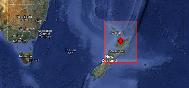
Image credit: EMSC + Google Earth
A strong and deep 6.3 magnitude earthquake struck North Island of New Zealand on December 7, 2012 at 18:19 UTC. Epicenter was located 18 km (11 miles) SE of Tokoroa, New Zealand, 27 km (16 miles) SW of Rotorua, New Zealand and 39 km (24 miles) N of Taupo, New Zealand at coordinates 38.334°S, 176.044°E. Recorded depth by USGS was 167.2 km (103.9 miles). Both USGS and EMSC reported magnitude 6.3. EMSC reported depth of 146 km.
Geonet / GNS Science reports a Magnitude of 5.8 at a depth of 175 km.
GDACS reported that this earthquake can have a low humanitarian impact based on the Magnitude and the affected population and their vulnerability. 550 000 people are living within 100 km.
| Magnitude | 6.3 |
|---|---|
| Date-Time |
|
| Location | 38.334°S, 176.044°E |
| Depth | 167.2 km (103.9 miles) |
| Region | NORTH ISLAND OF NEW ZEALAND |
| Distances | 18 km (11 miles) SE of Tokoroa, New Zealand 27 km (16 miles) SW of Rotorua, New Zealand 39 km (24 miles) N of Taupo, New Zealand 72 km (44 miles) S of Tauranga, New Zealand |
| Location Uncertainty | horizontal +/- 13.2 km (8.2 miles); depth +/- 8 km (5.0 miles) |
| Parameters | NST=173, Nph=181, Dmin=93.5 km, Rmss=1.71 sec, Gp= 47°, M-type=teleseismic moment magnitude (Mw), Version=8 |
| Source |
|
| Event ID | usc000e5z5 |
 December 7, 2012 – M 6.3 North Island of New Zealand
Tectonic summary by USGS
Seismotectonics of the Eastern Margin of the Australia Plate
The eastern margin of the Australia plate is one of the most seismically active areas of the world due to high rates of convergence between the Australia and Pacific plates. In the region of New Zealand, the 3000 km long Australia-Pacific plate boundary extends from south of Macquarie Island to the southern Kermadec Island chain. It includes an oceanic transform (the Macquarie Ridge), two oppositely verging subduction zones (Puysegur and Hikurangi), and a transpressive continental transform, the Alpine Fault through South Island, New Zealand.
Since 1900 there have been 15 M7.5+ earthquakes recorded near New Zealand. Nine of these, and the four largest, occurred along or near the Macquarie Ridge, including the 1989 M8.2 event on the ridge itself, and the 2004 M8.1 event 200 km to the west of the plate boundary, reflecting intraplate deformation. The largest recorded earthquake in New Zealand itself was the 1931 M7.8 Hawke’s Bay earthquake, which killed 256 people. The last M7.5+ earthquake along the Alpine Fault was 170 years ago; studies of the faults’ strain accumulation suggest that similar events are likely to occur again.
North of New Zealand, the Australia-Pacific boundary stretches east of Tonga and Fiji to 250 km south of Samoa. For 2,200 km the trench is approximately linear, and includes two segments where old (>120 Myr) Pacific oceanic lithosphere rapidly subducts westward (Kermadec and Tonga). At the northern end of the Tonga trench, the boundary curves sharply westward and changes along a 700 km-long segment from trench-normal subduction, to oblique subduction, to a left lateral transform-like structure. More information on regional seismicity and tectonics
I'm a dedicated researcher, journalist, and editor at The Watchers. With over 20 years of experience in the media industry, I specialize in hard science news, focusing on extreme weather, seismic and volcanic activity, space weather, and astronomy, including near-Earth objects and planetary defense strategies. You can reach me at teo /at/ watchers.news.
Commenting rules and guidelines
We value the thoughts and opinions of our readers and welcome healthy discussions on our website. In order to maintain a respectful and positive community, we ask that all commenters follow these rules.