
Magnitude 6.0 earthquake hit Papua, Indonesia
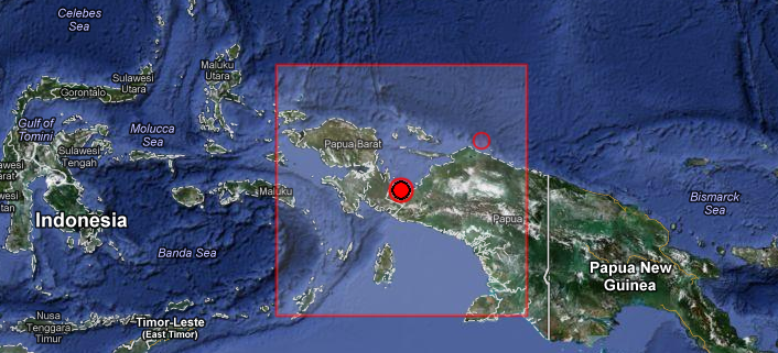
Image credit: TW
Strong earthquake with recorded magnitude 6.0 hit Papua, Indonesia on September 8, 2012 at 10:51 UTC according to USGS. Epicenter was located 160 km (100 miles) WNW (295°) from Enarotali, Irian Jaya, Indonesia at coordinates 3.199°S, 135.005°E. USGS recorded preliminary depth of 20.6 km (12.8 miles). EMSC also recorded magnitude 6.0 but the difference to USGS is in depth, they recorded 10 km.
This earthquake can have a low humanitarian impact based on the Magnitude and the affected population and their vulnerability. There are about 60 000 people living within 100 km.
The earthquake is not strong enough to generate a tsunami. Due to the close distance to the coast, a moderate shaking is expected in a radius of 50 km (will be felt by approx. 3000 people).
| Magnitude | 6.0 |
|---|---|
| Date-Time |
|
| Location | 3.199°S, 135.005°E |
| Depth | 20.6 km (12.8 miles) |
| Region | PAPUA, INDONESIA |
| Distances |
|
| Location Uncertainty | horizontal +/- 12.8 km (8.0 miles); depth +/- 6.5 km (4.0 miles) |
| Parameters | NST=117, Nph=118, Dmin=308.4 km, Rmss=1.12 sec, Gp= 22°, M-type=regional moment magnitude (Mw), Version=8 |
| Source |
|
| Event ID | usc000cium |

I'm a dedicated researcher, journalist, and editor at The Watchers. With over 20 years of experience in the media industry, I specialize in hard science news, focusing on extreme weather, seismic and volcanic activity, space weather, and astronomy, including near-Earth objects and planetary defense strategies. You can reach me at teo /at/ watchers.news.
Commenting rules and guidelines
We value the thoughts and opinions of our readers and welcome healthy discussions on our website. In order to maintain a respectful and positive community, we ask that all commenters follow these rules.