
Isaac’s eye wall to pass ‘right over’ Louisiana sinkhole
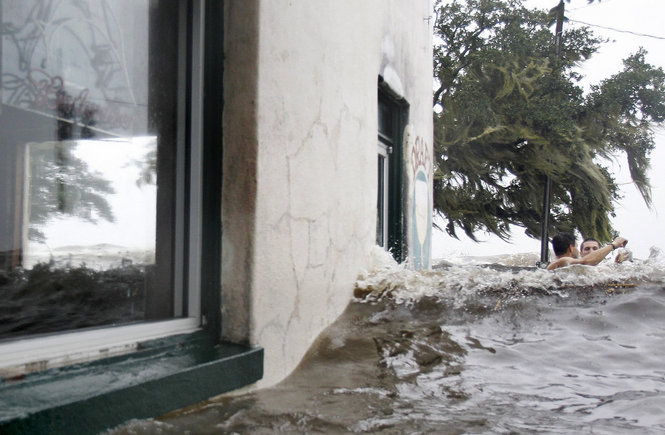
Image credit: (TED JACKSON / THE TIMES-PICAYUNE) Against the advice of authorities, men risk their lives for a few minutes in the high surf against the backdrop of the flooded out Don'z On the Lake bar on the Mandeville lakefront as Hurricane Isaac batters Mandeville with high winds and high tides, Wednesday August 29, 2012.
Slow-moving Isaac is dumping heavy rains and still producing a significant storm surge across southeastern Louisiana.
Strong bands of thunderstorms continue to develop over water in the eastern semicircle and also southwest of the center. They have occasionally produced sustained tropical-storm-force winds along with gusts exceeding 60 kt. Those strong rainbands will gradually spread westward tonight across the coastal areas of southeastern Louisiana and southern Mississippi, including the New Orleans metropolitan area.
Since Isaac will continue to move slowly over the next 24-36 hours there will be a prolonged threat of flooding from heavy rains over the northern Gulf Coast area and the south-central United States.
summary of 700 PM CDT…0000 UTC…information
———————————————-
location…30.1n 91.1w
about 30 mi…50 km S of Baton Rouge Louisiana
about 60 mi…95 km W of New Orleans Louisiana
maximum sustained winds…60 mph…90 km/h
present movement…NW or 315 degrees at 5 mph…7 km/h
minimum central pressure…977 mb…28.85 inches
At 00:00 UTC, the center of Tropical Storm Isaac was located by NOAA Doppler weather radar near latitude 30.1 north and longitude 91.1 west. Isaac is moving toward the northwest near 5 mph (7 km/h). This general motion is expected to continue through tonight followed by a turn toward the north-northwest by Thursday night or early Friday.
Isaac should continue to move northwestward and eventually northward through a weakness in the subtropical ridge over the next 36-48 hours. By day 3 when the remnant cyclone is over the upper-Midwest, Isaac should turn east-northeastward when it interacts with weak mid-latitude westerly flow.
")
The center of Isaac will move farther inland over Louisiana tonight and tomorrow and move over southern Arkansas by early Friday. Tropical-storm-force winds extend outward up to 175 miles (280 km) from the center. The estimated minimum central pressure based on nearby surface observations is 977 mb.
Maximum sustained winds have decreased to near 60 mph (90 km/h) with higher gusts. Belle Chasse Ferry Dock in Plaquemines Parish recorded wind speed of 113 mph (182 km/h). Steady weakening is expected during the next 48 hours as Isaac continues to move farther inland. Isaac is forecast to become a tropical depression by Thursday night.

A Tropical Storm Warning is in effect for Cameron Louisiana to the Mississippi-Alabama border
Even though Isaac is no longer a hurricane, life-threatening hazards from storm surge and inland flooding are still occurring. The combination of a storm surge and the tide will cause normally dry areas near the coast to be flooded by rising waters. The water could reach the following depths above ground if the peak surge occurs at the time of high tide:
* Mississippi and southeastern Louisiana…6 to 12 ft
* south-central Louisiana…3 to 6 ft
* Alabama…2 to 4 ft
* Florida Panhandle and Apalachee Bay…1 to 2 ft
The deepest water will occur along the immediate coast in areas of onshore winds. Surge-related flooding depends on the relative timing of the surge and the tidal cycle and can vary greatly over short distances. Near the coast the surge will be accompanied by large and dangerous waves. Shell Beach, Louisiana recorded storm surge height between 9 and 11 feet. A storm surge of nearly 7 feet is still occurring at Waveland Mississippi.

Isaac is expected to produce total rainfall amounts of 7 to 14 inches with possible isolated maximum amounts of 25 inches over much of Louisiana, southern and central Mississippi, southwest Alabama and southern and central Arkansas through Friday. These rains could result in significant lowland flooding. A levee in Plaquemines Parish will be breached to relieve pressure.
An unofficial rainfall total of 18.35 inches (466.09 mm) has been reported in Gretna Louisiana, located in metropolitan New Orleans. Audubon Park in New Orleans recorded 17.0 inches (431.8 mm) of rain.
Isolated tornadoes are possible along the central Gulf Coast region and parts of the lower Mississippi River valley through Thursday. SPC reported two tornadoes today in the Gulfport, MS area (Harrison County), which caused structural damage to several homes.
Dangerous surf and rip current conditions will continue to affect the West Coast of Florida and the northern Gulf Coast for the next day or so.
Eye wall over Louisiana sinkhole?!
Examiner reports Isaac slowly lashes toward Assumption Parish, only 53 miles southeast of Houma, Louisiana, less than 100 miles south of Bayou Corne’s sinkhole where a hurricane warning is in effect Wednesday. Officials report trees falling, power outages and floodings. All advisories released by the Assumption Parish Office of Homeland Security & Emergency Service remain. Isaac’s eye wall is expected to pass right over sinkhole area. The winds will become much stronger as the day progresses. Assumption Parish officials ordered a mandatory evacuation. Monday morning, officials there ask that people who remained in the area to “please abide by the curfew and remain sheltered in place.”
Radar
- New Orleans – Long Range (NOAA)
- Mobile – Long Range (NOAA)
Satellite Animations
- Storm-Centered Infrared (GOES 13; NOAA/SSD)
- Storm-Centered Infrared (Aviation Color Enhancement) (GOES 13; NOAA/SSD)
- Storm-Centered Water Vapor (GOES 13; NOAA/SSD)
- Storm-Centered Visible (GOES 13; NOAA/SSD)
- Storm-Centered Visible (Colorized) (GOES 13; NOAA/SSD)
- Gulf of Mexico Infrared (GOES 13; NOAA/SSD)
- Gulf of Mexico Infrared (Aviation Color Enhancement) (GOES 13; NOAA/SSD)
- Gulf of Mexico Water Vapor (GOES 13; NOAA/SSD)
- Gulf of Mexico Visible (GOES 13; NOAA/SSD)
- Gulf of Mexico Visible (Colorized) (GOES 13; NOAA/SSD)
Commenting rules and guidelines
We value the thoughts and opinions of our readers and welcome healthy discussions on our website. In order to maintain a respectful and positive community, we ask that all commenters follow these rules.