
A timeline of the most important events at the Bayou Corne sinkhole – Louisiana sinkhole (since May 2012)
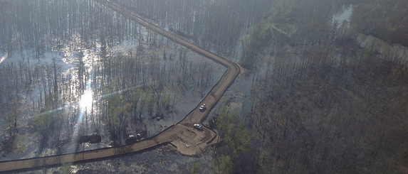
Image credit: Assumption Parish Police Jury - Taken on March 8, 2013
The Bayou Corne sinkhole, also known as Louisiana sinkhole, was discovered in August 2012 when a Napoleonville salt dome, a naturally-occurring underground salt deposit, suddenly collapsed after months of unexplained seismic activity and mysterious bubbling at the bayou. The sinkhole grew from 1 to 25 acres in just 12 months and the scariest part of it is that the collapse unlocked tens of millions of cubic feet of explosive gases, which have seeped into the aquifer and wafted up to the community (40 million cubic feet = 1.13 million cubic meters).
Texas Brine, the operator of the salt dome, specializes in a process known as injection mining and had been drilling around the dome in order to extract brine, which is used for refining oil. When they mined the salt dome too close to the edge of the dome, say officials, the side wall collapsed and 350 nearby residents were immediately advised to evacuate.
Assumption Parish declared a state of emergency and Governor Bobby Jindal declared a statewide state of emergency due to the threat of subsidence and subsurface instability that threatens the lives and property of the citizens of the state.
The following video is sinkhole flyover recorded on September 3, 2013. For comparison and more information, take a look at some of the previous flyover videos and images in a timeline of the most important events at the Louisiana sinkhole over the course of last 16 months:
Flyover video September 3, 2013
- On May 31, 2012, Assumption parish officials were notified of areas of bubbling spots in the Bayou Corne and Grand Bayou waterways. Early on, it was determined that the bubbling was caused by a release of natural gas and not “swamp gas”. Monitoring for carbon monoxide, H2Sm and Lower Explosive Levels (LEL) at the bubbling spots began on June 22, 2012. During this monitoring, no dangerous levels were detected. Residents within the community experienced and reported tremors and the parish requested the assistance of USGS in determining the locations and probable cause(s) for this seismic activity. USGS immediately detected seismic activity through their monitors and began recording this data; however, no probable cause was able to be detected.
- On August 3, 2012, one of the salt caverns Texas Brine hollowed out, a mine dubbed Oxy3, collapsed. Early in the morning, Assumption Parish Office of Homeland Security & Emergency Preparedness Director John Boudreaux was notified that a sinkhole had formed overnight in the swamp in the area. The hole was discovered after a strong diesel smell was experienced in the proximity of the sinkhole. On that same day, parish officials called for a mandatory evacuation of residents in the community and parish officials requested the assistance of state agencies in the activities involved in this emergency. The sinkhole initially spanned about an acre.
Flyover video August 13, 2012
– @ .01 is the site of the well pad where Texas Brine will drill
– @ .09 is the site where Acadian Ambulance Services have been staged for emergency purposes
– @.19 is the well pad of Cavern #3 where the de-con team is staged
– @ .26 is the sinkhole/slurry site
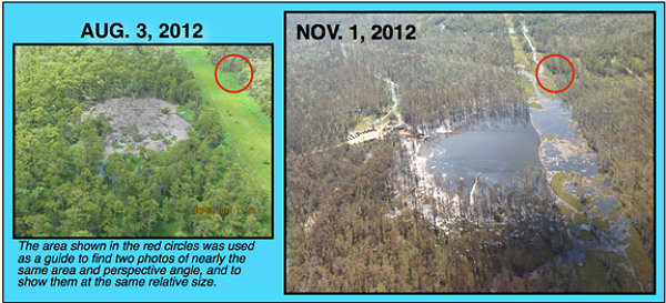
- On October 11, 2012, photographer Jeffrey Dubinsky took a flight for LEAN and LMRK over the sinkhole. After the flight, Jeffrey commented on the intense petroleum fumes experienced while flying over the sinkhole area.
"I will say the odor was the heaviest and strongest I have ever experienced in all my time in Louisiana. Perhaps even worse still was that the odor was hovering directly over the community… I have no idea whatsoever how the workers can tolerate being anywhere near it."
Flyover video October 11, 2012
- On October 14, 2012, first official map of the Louisiana sinkhole dimensions was uploaded to the Assumption Parish website:
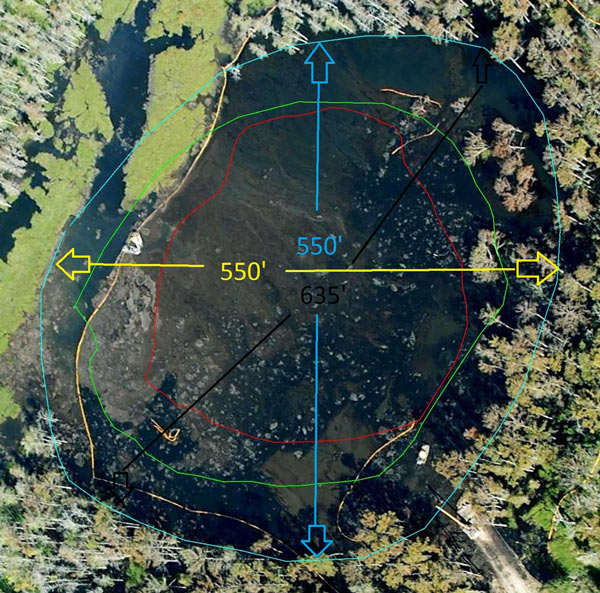
Red Line: August 19, 2012
Green Line: September 21, 2012
Blue Line: October 14, 2012
Yellow line is oil boom
- On October 30, 2012, a large slough in occurred at the sinkhole site. Disturbing new flyover videos of Louisiana sinkhole showed the amount of land collapsed has increased in size. Last measurements show that the surface of the sinkhole area was 5.5 acres, or equivalent of five football fields.
- On January 19, 2013, heavy rains caused another collapse. Several trees on the southern perimeter sloughed into the sinkhole on January 20, 2013. Bubbling activity were reported at eleven new sites in a Louisiana swampland, west of a collapsing Bayou Corne sinkhole, following several days of increased seismic activity (being detected by the surface geophones). There are now 34 known bubble sites in the Bayou Corne and Grand Bayou in the area of the collapsing salt dome. Some bubble sites in the area preceded the formation of the sinkhole by several months but more have been discovered over time.
- Officials monitoring the giant sinkhole in Louisiana reported that massive slurry burped on the morning of March 17, 2013. Boudreau said nearly an acre of land fell off into the west side of the sinkhole. (1 acre = 4 046.86 m2.) More debris and hydrocarbon appeared at the surface, he added. Assumption Parish Blog reported that the Office of Conservation is advising the public that a large “burp” event is related to the recent period of elevated deep seismic activity around the failed Oxy 3 cavern and the sinkhole.
- The Office of Conservation, in consultation with Assumption Parish Police Jury, advised the public on March 28, 2013, that the Oxy 3/sinkhole monitoring alert status has been raised to Code 2 – requiring all work directly in and over the sinkhole to cease until further notice. Giant Louisiana sinkhole swallowed 25 trees and a well pad access ramp, so now the collapsed area grew to 13 acres in size.
Flyover video taken on March 28, 2013
- In May 2013, a federal court has approved a class-action lawsuit for people impacted by the giant Louisiana sinkhole. Sinkhole area covered approximately 15 acres (6.1 ha).
- Abundant surface water movement and burp event in the center of the sinkhole started early on July 19, 2013. Video bellow, released on the same day shows sudden water movement at sinkhole area with tidal wave characteristics:
Water movement at the Sinkhole – July 19, 2013
Lakes and smaller bodies of water do not normally have "tidal waves" which are typical only for oceans and seas but also bodies of water that are connected with them. There are some suggestions that Louisiana sinkhole somehow connected with the Gulf of Mexico through the salt dome and the Louann salt layer which connects all of these salt domes and covers over 7 states. The Louann underlies much of the northern Gulf coast from Texas to the Florida panhandle and extends beneath large areas of the Gulf coastal plain of Mississippi, Louisiana and Texas. Pressure, sediment movements, another floor collapse, gas leak…there is a list of possible causes.
The burps are occurring about once a month now. Experts estimate over 200 million cubic feet of gas in area under giant Louisiana sinkhole. A massive methane deposit could take years to drain.
At Assumption Parish public briefing held on July 16, 2013 Gary Hecox, CB&I hydrogeologist stressed that they have talked to some of the leading experts in the world as too what could be causing the problem. Here is his short statement from the briefing:
"Nobody’s ever encountered anything like this in the history of mankind. I’m not kidding, what’s going on with that cavern where it’s going up several hundred feet and down several hundred feet, we don’t know if it’s some equipment issues or if there’s something going on in the cavern that we don’t understand. The pressure in the cavern continues to slowly increase. It’s up now to almost 600psi in the wellhead, that’s brine pressure not gas. I don’t even have a good hypothesis to tell you. The world experts have looked at this and we don’t know."
- On July 20, 2013, Emergency managers in Assumption Parish dropped a weight in the sinkhole and discovered it fell the entire length of the weight's cord, which was 230 m (750 feet).
Depth measure of the Sinkhole – July 20, 2013
- Texas Brine Co. has offered buyouts to those affected by the sinkhole and 44 of 92 buyout offers have been accepted as of July 2013. However, Many residents have chosen to stay, risking the fact that the Louisiana sinkhole may expand and ruin infrastructure and homes, or even the highway, Louisiana 70. They also risk natural gas coming to the surface, possibly causing explosions. Officials say that gas has been detected under at least four homes, but in low levels.
- Another burp event at Louisiana sinkhole was reported on August 21, 2013. According to Assumption Parish Police Jury all operations have been pulled from inside of the sinkhole until activity calms down. The monitoring/alert status has been heightened to Code 3. Code 3 restricts all work inside the containment berm, indicates seismic activity has elevated to a point similar to what has been seen in past monitoring prior to a sloughing on the shore or movement beneath sinkhole (More than 50 MEQs or VLPs in 24 hours)
Slough in – August 21, 2013
- In August 2013, the sinkhole expanded to as large as 25 acres (10 ha) after swallowing several large trees within seconds and is being described as the biggest ongoing industrial disaster in the United States you haven't heard of.
- September 26, 2013:
Bayou Corne/Grand Bayou Response Activity
Thursday, Sep. 26 – Sinkhole Activity Code 2 – elevated – increase in number of Very Long Profile seismic activity, generally associated with movement of gas/fluid below sinkhole, in area of sinkhole/Oxy 3 cavern – requires halting all work directly on sinkhole. (Source)
October 29, 2013 – Maps presented:
The links below access the maps that were presented at a meeting held by Texas Brine last week (10/24).
Cone Pentrometer Test (CPT) Boring Locations
Proposed Observation Relief Wells & Mississippi River Aluvial Aquifer (MRAA) Contours
MRAA Gas Zone Thickness in Bayou Corne
- October 30, 2013 – Statement from Texas Brine:
RECENT SEISMIC ACTIVITY
There has been a recent increase in seismic activity detected on the Texas Brine seismic instrumentation over the last ten days. These occurrences consist primarily of minor tremors or “micro-earthquakes” (MEQ’s) and not extended events or very long period (VLP) tremors. Additional monitoring and interpretation of the data from the newly installed borehole seismic array is being performed in order to better understand the location and magnitude of the seismic activity. This monitoring and analyses is performed by industry specialists, along with government and university experts, which has been the case from the very beginning of the response.
Texas Brine, in coordination with DNR and APOEP, recently relocated sensors and added additional resources to the passive seismic monitoring system already in place. This is all part of a coordinated effort to better monitor for tremors and pinpoint tremor locations with greater accuracy. Response personnel are closely watching this situation and if additional information becomes available about the source and location of the activity, the community will be updated. (Source)
- November 5, 2013 – APPJ posted:
Assumption Parish Incident Command and the Office of Conservation are providing initial results of Itasca’s study on potential future ground-level subsidence in the Bayou Corne area. The findings are preliminary and conservative, pending further refinement of data from survey points to date and information to be gathered in future surveys – but are being made available to ensure that residents of the Bayou Corne community have the best and most up-to-date information that has been developed thus far.
Louisiana DOTD indicates that the subsidence projected for La. 70 in this initial study is within a range that can be managed with standard practices for road maintenance and overlay over the 30-year period modeled. However, out of an abundance of caution, DOTD continues to evaluate possible detour routes in case a need for one should arise.
The study found that normal subsidence levels are projected to be present in the area over the next 30 years. The charts summarizing the initial estimates of potential future subsidence are all based on total cumulative subsidence from the present time to different points in the future – 1.5 years, 5 years, 10 years and 30 years out – and do not distinguish between historical subsidence driven by Louisiana’s normal geologic processes and increases in expected subsidence due to the failure of the Oxy Geismar 3 cavern and subsequent development of the disturbed rock zone and sinkhole. For reference, Itasca has used available historic survey data to estimate that normal rates of subsidence in the Bayou Corne area west of the Napoleonville Salt Dome are in a range of .2 to .4 inches per year, or 2 to 4 inches every 10 years.
Follow this link for initial Itasca subsidence estimates: http://dnr.louisiana.gov/index.cfm?md=pagebuilder&tmp=home&pid=1150
- November 6, 2013
Sinkhole Activity Code 2 – indicating no work is allowed directly on sinkhole, seismic monitoring indicates MEQ (micro-earthquake) activity near sinkhole/Oxy 3 has declined in comparison to recent activity, but still somewhat elevated. (Source)
- December 16, 2013
Sinkhole Activity Code 1+ – indicating work is allowed on sinkhole and containment berm, however, seismic monitoring indicates levels of sub-surface activity near sinkhole/Oxy 3 have been trending upward over the past two days. (Source)
- December 19, 2013
Sinkhole Activity Code 3 – indicating no work is allowed directly on sinkhole or within containment berms. Seismic monitoring indicates further increase in levels of subsurface activity near sinkhole/Oxy 3 – state and parish will continue to closely observe seismic activity to advise of any sudden changes. (Source)
- December 23, 2013
Images taken on December 23 showed that south berm developed new cracks where a previous crack was repaired. New cracks were observed in the lowest part of the berm (in a half moon shape). Report from same day said: "the Micro Seismic Activity (MEQ) has been up for the last few days, with counts as high as 180 MEQ’s yesterday."
In other words, the workers are having hard time keping the southern berm in shape.
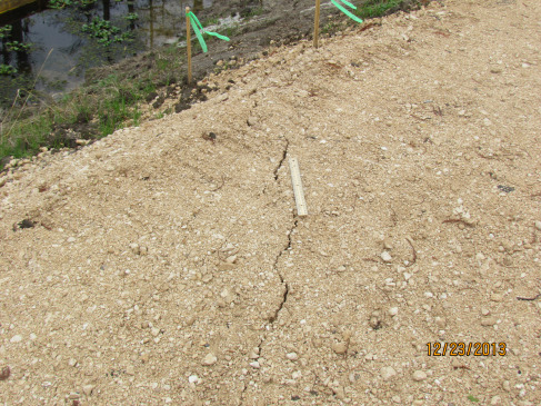
Picture of the cracks where previous repair was completed. December 23, 2013. Image credit: Assumption Parish Police Jury
- December 31, 2013
Images taken on the morning of December 31showed the ongoing subsidence of the center portion of the southern berm.
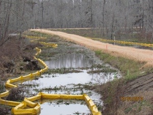
Subsedience of the center portion of the southern berm. December 31, 2013. Image credit: Assumption Parish Police Jury
Statement from Texas Brine, re: South Berm
"Today, in discussion with and approval from DNR and APOEP, Texas Brine has received permission to proceed with temporary repair work to the south berm in order to raise the height of the berm to protect against any immediate potential for overtopping due to subsidence.
As part of this discussion, TBC has agreed to move forward with planning and submission of Emergency Use Authorizations and engineering designs for the installation of a new southern containment structure.
TBC will then proceed with the installation of this new southern containment system once the requisite permission and approvals have been received from DNR, DEQ, and APOEP."
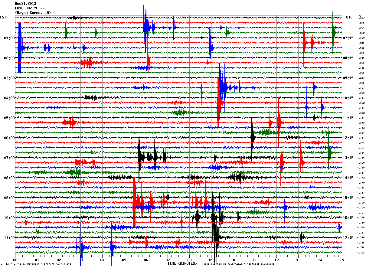
Image source: ceri.memphis.edu
- January 1, 2013
Data from LA14 seismic monitoring station:
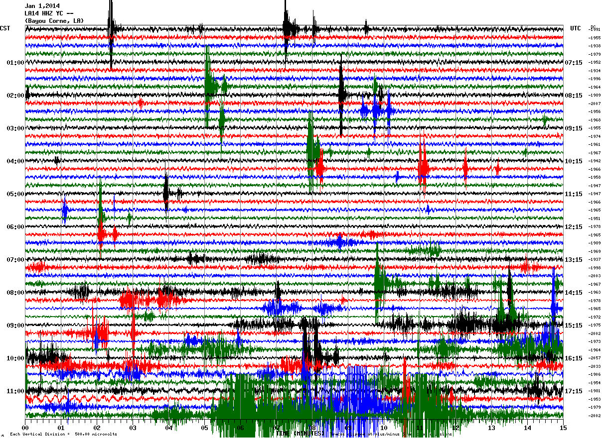
Image source: ceri.memphis.edu
- January 2, 2013
12 Noon Update from the Office of Conservation
Assumption Parish Police Jury reported today [again] that seismic monitoring indicates further increase in levels of subsurface activity near sinkhole/Oxy 3. Sinkhole Activity Code is on 3 indicating no work is allowed directly on sinkhole or within containment berms.
Report:
Sinkhole Activity Code 3 – indicating no work is allowed directly on sinkhole or within containment berms. Seismic monitoring indicates further increase in levels of subsurface activity near sinkhole/Oxy 3 – state and parish will continue to closely observe seismic activity to advise of any sudden changes.
Air Monitoring/Sub-slab Sampling and Ventilation
– Conducting ventilation system inspections
ORW/CPT Wells
– De-pressurizing ORW 54 (north of La 70, west of Texas Brine facility) to change out wellhead
– Monitoring bubble site 56 (Bayou Corne, north of La 70)
– Downloading transducer and tracking data from ORWs
Containment Berm/Roads/Sinkhole
– Repairing and building up low areas on southern containment berm
– Re-stocking sand and gravel supplies for berm maintenance/repair
.gif)
Image source: ceri.memphis.edu
- January 3, 2013
Data from LA14 seismic monitoring station:
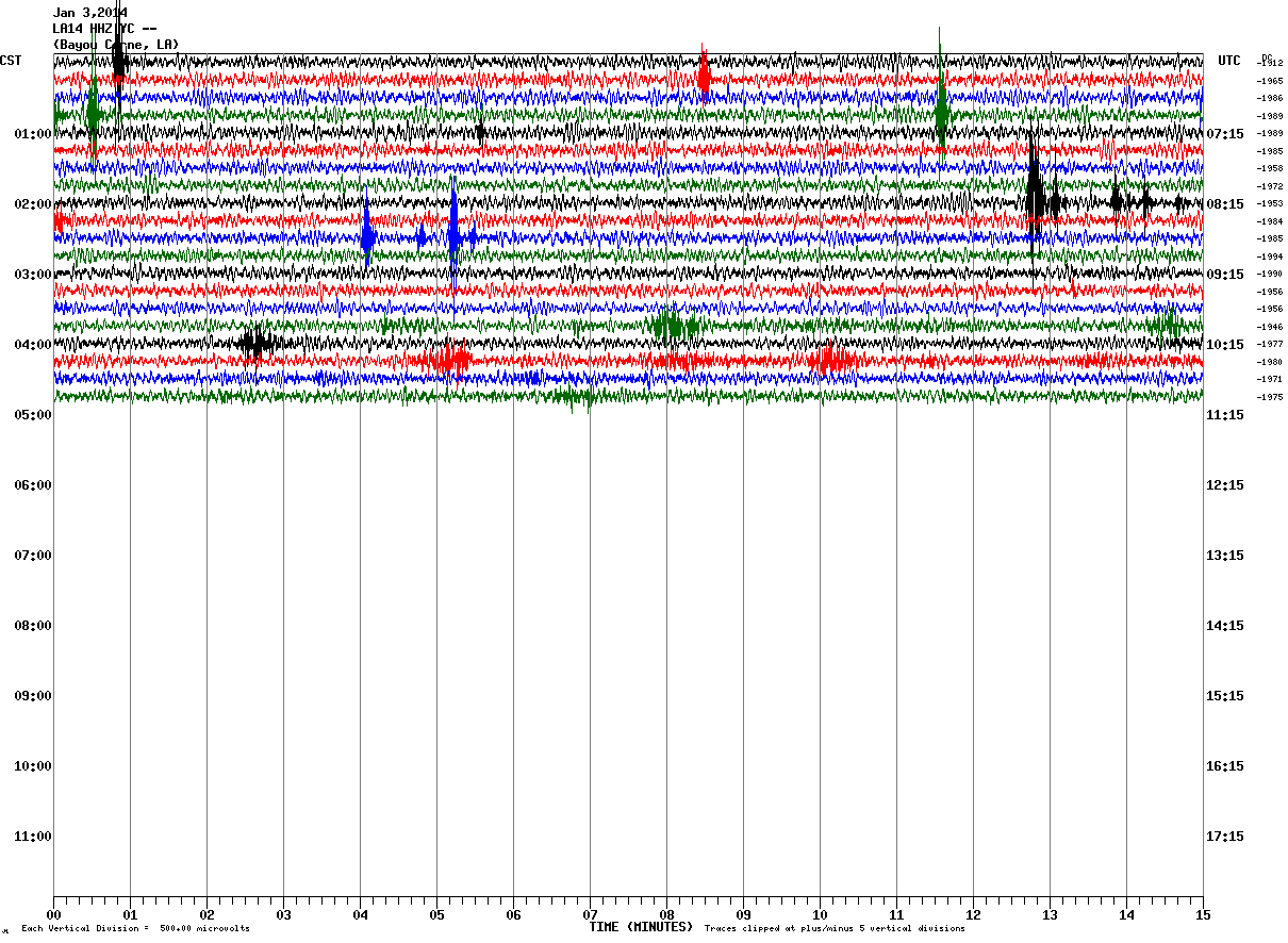
Image source: ceri.memphis.edu
Sources: AssumptionLa, TheAtlanticCities, TW archive
I'm a dedicated researcher, journalist, and editor at The Watchers. With over 20 years of experience in the media industry, I specialize in hard science news, focusing on extreme weather, seismic and volcanic activity, space weather, and astronomy, including near-Earth objects and planetary defense strategies. You can reach me at teo /at/ watchers.news.
This is a very nice timeline! It is good that there are people like you who report on this, who make us aware that this is going on with Earth. Thank you for your time and effort! I think humanity is finding itself in a real pickle. On the one hand we really like what the resources we are forcefully extracting from Earth afford us. But on the other hand we know, even if for some this knowledge is pushed deep down, that we are harming this planet with our practices. We have two options. (1) We can own up to the fact that we are creating what happens around us, take full conscious responsibility for our actions, and find the least harmful ways to fulfill our needs and perhaps even adjust our needs. We are very smart and ingenuous after all. Or (2), we refuse to take conscious responsibility for our actions even tough we continue to create and shape the world around us. Some things that can't be seen or talked about we will just bury out of sight by words, by actions, or both. Either the entire world, a country, a city or village, a family or group of people, or a single person. Banned darkness. This here is an example of banned darkness, one of our dirty little secrets that no one really wants to talk about (hence the lack of exuberant coverage in the mainstream media) because the implications are HUGE. Are we brave enough to look that in the eye? Because this is not just about Louisiana and some company making mistakes. This is about all of us turning a blind eye on a harmful resource extraction process while we all reap the benefits. This is about an entire industry that is harmful and we are all complacent, we are all *allowing* them to do this kind of stuff. And yes, if you weren't already thinking it, the same goes for nuclear power and the Fukushima disaster. Earth is what we make it. Take a good long look at that sinkhole. Take a good long look at the Fukushima disaster. And then ask yourselves, is this the Earth you want? Don't get depressed though. You don't have to stay stuck there! Think long and hard about what you *do* want Earth to be like as well, and then go create it any chance you get! Every little bit helps! Don't have extra time or money? Even just changing your thoughts helps! If you start thinking positively and about the things you would like to happen to you, to humanity and the Earth you'll feel a lot better, and it opens you up to all kinds of new creative possibilities that don't come to mind when you think negatively. Makes sense right? Mahatma Gandhi said, "Be the change you wish to see in the world." All change starts with a simple thought. It's free, and it's all yours!
In other news> If a Hurricane Doesn’t Form in the Next 10 Days, 2013 Will Go Down as Slowest Start to Hurricane Season in Satellite History. That's what happens when there is less solar activity and less sunspots, which brings the earth into a mini cooling for many decades to come.