
Strong and deep M 6.4 earthquake hit Molucca Sea, Indonesia
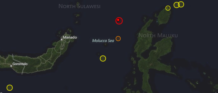
Image credit: TW
Very strong and deep earthquake with recorded magnitude of 6.4 struck Molucca Sea, Indonesia on August 26, 2012 at 15:05 UTC, 11:05 pm local time, according to USGS. Both USGS and EMSC recorded preliminary magnitude of 6.8. Epicenter was located 169 km (105 miles) NNW (340°) from Ternate, Moluccas, Indonesia at coordinates 2.231°N, 126.865°E. Recorded depth was 69.7 km (43.3 miles). EMSC later reported magnitude 6.6 and depth of 80 km.
The earthquake was felt in a wide area in Indonesia and the Philippines, mainly because of the deep origin of the hypocenter.
NOAA/NWS – Pacific Tsunami Warning Center evaluated that this earthquake had no destructive widespread tsunami threat based on historical earthquake and tsunami data.
GDACS reported that this earthquake can have a low humanitarian impact based on the Magnitude and the affected population and their vulnerability. About 6000 people live within 100km.
| Magnitude | 6.4 |
|---|---|
| Date-Time |
|
| Location | 2.231°N, 126.865°E |
| Depth | 69.7 km (43.3 miles) |
| Region | MOLUCCA SEA |
| Distances |
|
| Location Uncertainty | horizontal +/- 13.4 km (8.3 miles); depth +/- 7.2 km (4.5 miles) |
| Parameters | NST=250, Nph=250, Dmin=170.3 km, Rmss=1.18 sec, Gp= 14°, M-type=regional moment magnitude (Mw), Version=8 |
| Source |
|
| Event ID | usc000c76x |

Historic seismicity map – 2012

I'm a dedicated researcher, journalist, and editor at The Watchers. With over 20 years of experience in the media industry, I specialize in hard science news, focusing on extreme weather, seismic and volcanic activity, space weather, and astronomy, including near-Earth objects and planetary defense strategies. You can reach me at teo /at/ watchers.news.
Commenting rules and guidelines
We value the thoughts and opinions of our readers and welcome healthy discussions on our website. In order to maintain a respectful and positive community, we ask that all commenters follow these rules.