
First hurricane of 2012 Pacific season approaches Mexico’s coast
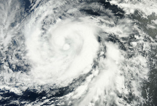
Image credit: TW
Category 2 Hurricane Bud is forecast to weaken before reaching Mexico’s coastline tonight, Friday, May 25, between Manzanillo and Puerto Vallarta. Bud is forecast to be at or near hurricane strength. It is then expected to stall near or on the coast through Saturday and continue weakening before heading back to sea on Sunday. Bud reached Category 3 status for several hours last night. At this moment Bud is Category One hurricane.

Hurricane Bud is currently located about 130 km (80 miles) west of Manzanillo and about 135km (85 miles) south of Cabo Corrientes (19.2N 105.5W) according to latest public advisory by National Hurricane Center (NHC) issued at 21:00 UTC on May 25th. Data from the Hurricane Hunter aircraft indicate that the maximum sustained winds are near 120 km/h (75mph). The system is moving north at speed of 11km/h (7mph). Central pressure of the storm is 995MB. Right now, a hurricane warning is in effect for the coast of Mexico from Manzanillo northwestward to Cabo Corrientes and hurricane watch is in effect for the coast of Mexico from Punta San Telmo westward to east of Manzanillo.
Bud is expected to produce total rain accumulations of 6 to 10 inches along the southwestern coast of Mexico in the states of Michoacan, Colima, Jalisco and southern Nayarit. These rainfall amounts could produce life-threatening flash floods and mudslides. A dangerous storm surge is expected to cause significant coastal flooding near and to the east of where the center of Bud comes ashore. The surge will be accompanied by large and damaging waves. Heavy surf and rip current conditions are also possible along the southwestern coast of Mexico. (National Hurricane Center)

Satellite Animations
- Storm-Centered Infrared (GOES 13; NOAA/SSD)
- Storm-Centered Infrared (Aviation Color Enhancement) (GOES 13; NOAA/SSD)
- Storm-Centered Water Vapor (GOES 13; NOAA/SSD)
- Storm-Centered Visible (GOES 13; NOAA/SSD)
- Storm-Centered Visible (Colorized) (GOES 13; NOAA/SSD)
- Tropical East Pacific Hurricane Sector Infrared (GOES 15; NOAA)
- Tropical East Pacific Hurricane Sector Water Vapor (GOES 15; NOAA)
- Tropical East Pacific Hurricane Sector Visible (GOES 15; NOAA)
Commenting rules and guidelines
We value the thoughts and opinions of our readers and welcome healthy discussions on our website. In order to maintain a respectful and positive community, we ask that all commenters follow these rules.