
Typhoon Sanvu expected to veer northeast after weakening to tropical storm
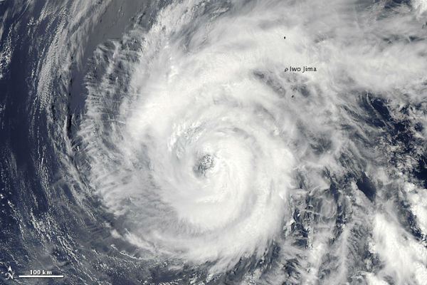
Image credit: NASA image courtesy Jeff Schmaltz, LANCE MODIS Rapid Response Team at NASA GSFC. Caption by Michon Scott.
This year’s first typhoon – Sanvu, is located 60 nm southwest of island Iwo To near Japan and is moving northwestward at speed of 9 knots according to Joint Typhoon Warning Center (JTWC). System generated winds of 75 knots (140km/h or 87 mph) with gusts of 90 knots (167 km/h or 104 mph). Sanvu produced maximum significant wave heights of 9,5 meters (31 feet).

Sanvu first formed as a tropical depression over the western Pacific Ocean on May 21, 2012, strengthened to a tropical storm the same day, and became a typhoon two days later. Typhoon Sanvu has become the year’s first typhoon, and the first such storm since early October 2011. No major land masses are under threat from Sanvu, which will track near a few small remote islands later in the week. Typhoon Sanvu is expected to veer northeast to the open Pacific Ocean after weakening to a tropical storm.

Satellite Animations
- Storm-Centered Infrared (MTSAT2; NOAA/SSD)
- Storm-Centered Infrared (Aviation Color Enhancement) (MTSAT2; NOAA/SSD)
- Storm-Centered Water Vapor (MTSAT2; NOAA/SSD)
- Storm-Centered Visible (MTSAT2; NOAA/SSD)
- Storm-Centered Visible (Colorized) (MTSAT2; NOAA/SSD)
- Tropical West Pacific Infrared (MTSAT2; NOAA)
- Tropical West Pacific Enhanced Infrared (MTSAT2; NOAA)
- Tropical West Pacific Water Vapor (MTSAT2; NOAA)
- Tropical West Pacific Visible (MTSAT2; NOAA)
Commenting rules and guidelines
We value the thoughts and opinions of our readers and welcome healthy discussions on our website. In order to maintain a respectful and positive community, we ask that all commenters follow these rules.