
Category One Hurricane BUD continues to strenghten
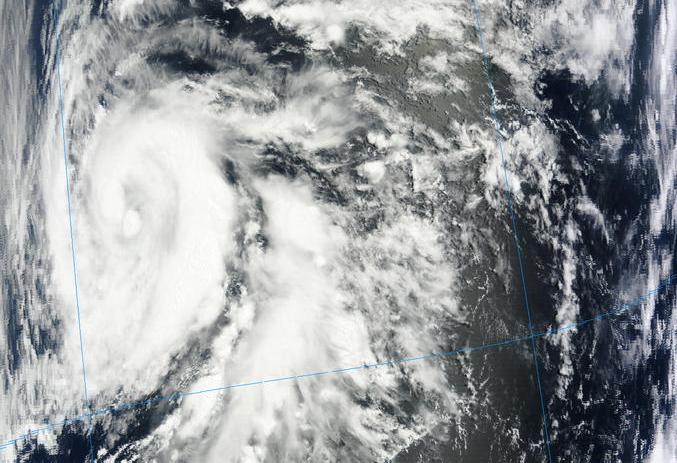
Image credit: rapidfire.sci.gsfc.nasa.gov
Tropical Storm Bud continues to quickly strengthen and now is categorized as Category One Hurricane. Hurricane force winds extend outward up to 35 km (25 miles) from the center and tropical storm force winds extend outward up to 185 km (115 miles). Estimated minimum pressure is 980MB. Hurricane Bud is moving toward the north near 11km/h (7 mph). Maximum sustained winds have increased to near 140 km/h (85 mph) with higher gusts. A turn toward the northeast is expected today and this heading with a decrease in forward speed is expected through Friday.


The center of Bud is expected to approach the southwestern coast of Mexico late Friday. The government of Mexico has issued a tropical storm warning along the Pacific coast from Punto Telmo westward to Cabo Corrientes. A Hurricane watch has also been issued from Punto Telmo westward to Cabo Corrientes.
SUMMARY OF 200 AM PDT...0900 UTC...INFORMATION

----------------------------------------------

LOCATION...15.0N 107.5W

ABOUT 350 MI...560 KM SW OF MANZANILLO MEXICO

ABOUT 390 MI...630 KM SSW OF CABO CORRIENTES MEXICO

MAXIMUM SUSTAINED WINDS...85 MPH...140 KM/H

PRESENT MOVEMENT...N OR 10 DEGREES AT 7 MPH...11 KM/H

MINIMUM CENTRAL PRESSURE...980 MB...28.94 INCHES

Bud is expected to produce total rain accumulations of 4 to 6 inches along the southwest coast of Mexico from the states of Michoaca, Colima, Jalisco and Southern Nayarit with possible isolated maximum amount of 10 inches. These rainfall amounts could produce life-threatening flash floods and mudslides.
Swells generated by Bud will begin affecting portions of the southern and southwestern coasts of Mexico today. These swells are likely to cause life-threatening surf and rip current conditions.
Source: NWS/National Hurricane Center, Joint Typhoon Warning Center (JTWC)
Satellite Animations
- Storm-Centered Infrared (GOES 13; NOAA/SSD)
- Storm-Centered Infrared (Aviation Color Enhancement) (GOES 13; NOAA/SSD)
- Storm-Centered Water Vapor (GOES 13; NOAA/SSD)
- Storm-Centered Visible (GOES 13; NOAA/SSD)
- Storm-Centered Visible (Colorized) (GOES 13; NOAA/SSD)
- Tropical East Pacific Hurricane Sector Infrared (GOES 15; NOAA)
- Tropical East Pacific Hurricane Sector Water Vapor (GOES 15; NOAA)
- Tropical East Pacific Hurricane Sector Visible (GOES 15; NOAA)
- Tropical East Pacific and Caribbean Basin Infrared (GOES 13; NOAA/SSD)
- Tropical East Pacific and Caribbean Basin (Aviation Color Enhancement) (GOES 13; NOAA/SSD)
- Tropical East Pacific and Caribbean Basin Water Vapor (GOES 13; NOAA/SSD)
- Tropical East Pacific and Caribbean Basin Visible (GOES 13; NOAA/SSD)
- Tropical East Pacific and Caribbean Basin Visible (Colorized) (GOES 13; NOAA/SSD)
Commenting rules and guidelines
We value the thoughts and opinions of our readers and welcome healthy discussions on our website. In order to maintain a respectful and positive community, we ask that all commenters follow these rules.