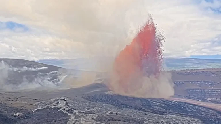
• NWS confirms long-track EF3 tornado in Mississippi outbreak

    The National Weather Service office in Jackson, Mississippi, determined after additional damage surveys that two EF3 tornado tracks documented during the May 6-7, 2026 severe weather outbreak were part of one continuous long-track tornado. Survey teams also confirmed an EF2 tornado near Purvis in Lamar County as assessments continued across southern Mississippi.

  • Nighttime tornadoes injure 17 and damage hundreds of homes in Mississippi

    Nighttime tornadoes and severe thunderstorms tore across central and western Mississippi on Wednesday night, May 6, 2026, damaging hundreds of homes and injuring at least 17 people, according to state emergency officials. Authorities reported concentrated damage in Bogue Chitto, where a trailer park sustained heavy destruction.

  • Tornado Emergency issued as large tornado hits Brookhaven area, Mississippi

    A large, destructive tornado moved through the Brookhaven area of southern Mississippi during the evening of May 6, 2026, after the National Weather Service in Jackson issued a Tornado Emergency for communities including Brookhaven and Bogue Chitto. The event developed within an SPC Enhanced Risk severe weather setup and produced repeated radar-confirmed Tornado Debris Signatures as the storm moved from Franklin County into Lincoln County and toward Lawrence County.

  • Enhanced Risk of severe thunderstorms from Louisiana through Mississippi into Alabama on May 6

    An Enhanced Risk (Level 3/5) of severe thunderstorms has been issued for parts of the Lower Mississippi Valley on May 6, 2026, as forecasters warned that storms capable of producing damaging winds, large hail, and tornadoes are expected to develop from the Southern Plains into the Southeast. Heavy rainfall rates of 25 to 50 mm (1 to 2 inches) per hour may also accompany stronger storms across the region.

  • Heavy, wet May snow disrupts Colorado’s Front Range

    A heavy, wet late-season snowstorm affected Colorado’s Front Range, foothills, mountains, and I-25 urban corridor from Tuesday, May 5, into Wednesday, May 6, 2026, closing schools, prompting travel advisories and shelter activation, delaying flights at Denver International Airport, and causing scattered power outages. NWS Denver/Boulder forecast 13-20 cm (5-8 inches) along the I-25 corridor, with local totals up to 30 cm (12 inches) near the foothills and Palmer Divide. Heavier mountain snow was also forecast along and north of I-70, where CDOT warned of hazardous travel conditions.

  • Kīlauea episode 46 ends after 9 hours of lava fountaining, tephra reaches Highway 11, Hawaii

    Episode 46 of the ongoing Halemaʻumaʻu eruption at Kīlauea ended at 17:22 HST on May 5, 2026 (03:22 UTC on May 6), after about 9 hours of continuous lava fountaining from the north vent at the summit. USGS lowered the Volcano Alert Level from Watch to Advisory and the Aviation Color Code from Orange to Yellow after ground and aviation hazards decreased.

  • Storm-force winds and high seas forecast over western Atlantic as offshore low rapidly intensifies

    Storm-force winds and high seas are forecast over parts of the western Atlantic on Sunday, May 3, 2026, as a rapidly deepening low-pressure system moves northeast off the U.S. East Coast. The NWS Ocean Prediction Center issued storm warnings for offshore waters, with forecast winds reaching 110 km/h (70 mph) and seas building up to 7 m (23 feet).

  • Flash floods leave 1 dead in San Antonio, Texas

    One person died in San Antonio, Texas, on May 1, 2026, after flash floods spread across urban areas during periods of heavy rainfall. Police and fire crews recovered the victim from a drainage channel as floodwaters impacted roads and infrastructure.

  • Monster 18 cm (7.1 inch) hailstone sets new state record in Texas

    What initially looked like a discarded gallon jug in a roadside ditch turned out to be a record-breaking hailstone, now confirmed as the largest ever documented in Texas at roughly 18 cm (7.1 inches). It was discovered near Vigo Park in Swisher County by storm chaser Val Castor and his associates on June 2, 2024. They clicked several pictures of the hailstone alongside objects to provide a visual reference of size and submitted them to the Insurance Institute for Business and Home Safety (IBHS). The size of the hailstone was determined using photogrammetry and AI analysis along with the estimates from the storm chasers.

  • NWS rates Mineral Wells tornado EF3 after severe storms in Texas

    The National Weather Service preliminarily rated the Mineral Wells tornado in Texas as EF3, with estimated peak winds of 233 km/h (145 mph), after surveying damage from the April 28, 2026, severe weather event. NWS listed 5 injuries and 0 fatalities, while Mineral Wells officials kept a curfew in place for the affected area as cleanup and damage assessment continued.