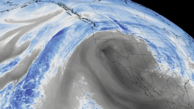
• Blizzard Warnings issued for Delaware, New Jersey, New York and southern Connecticut February 22-23

    Blizzard Warnings were issued February 21, 2026, for parts of Delaware, New Jersey, New York, and southern Connecticut, with heavy snow and wind gusts up to 90 km/h (55 mph) forecast from February 22 through 18:00 EST on February 23. Snow accumulations of 15–50 cm (6–20 inches) are expected, with visibility potentially dropping below 0.4 km (0.25 miles) in blowing snow, producing whiteout conditions and dangerous travel.

  • Coastal storm and long-duration atmospheric river to bring heavy precipitation to Pacific Northwest and California

    A slow-moving low-pressure system is forecast to bring long-duration atmospheric river conditions to the U.S. West Coast between Saturday, February 21, and Wednesday, February 25, 2026, delivering heavy precipitation from Washington to California. The strongest impacts are expected across southern Oregon and northern California Coast Ranges and the Klamath Mountains, where 5-10 inches (125-250 mm) of rain is forecast.

  • Confidence increases for significant winter storm to impact Northeast and Mid-Atlantic

    Forecast confidence is increasing for an impactful winter storm to hit the Northeast and the Mid-Atlantic over the weekend into Monday, February 23, 2026. Lake-enhanced and lake-effect snow are forecast as the storm moves into the Great Lakes Region starting Saturday, February 21. Snowfall rates of over 25 mm (1 inch) an hour coupled with gusty winds will create dangerous travel conditions with low visibility and slick roads.

  • Wildfires trigger Agricultural Emergency as Texas activates expanded state response ahead of critical fire danger

    Wildfires burning across the Texas Panhandle and West Texas prompted Agriculture Commissioner Sid Miller to declare an Agricultural Emergency on February 18, 2026, while Governor Greg Abbott directed the Texas Division of Emergency Management to activate additional state wildfire response resources ahead of elevated-to-critical fire weather conditions across South, West, and Northwest Texas. Extremely critical fire danger continues across portions of the state as dry fuels and periodic wind gusts persist.

  • Winter storm warnings and advisories issued across Great Lakes and Northeast U.S.

    Winter Storm Warnings and Winter Weather Advisories were issued across parts of Michigan, New York, New England, and Pennsylvania early Friday, February 20, 2026, with heavy snow and ice forecast to impact travel through February 21. Snowfall totals of 10 to 28 cm (4 to 11 inches) and ice accumulations up to 6 mm (0.25 inches) are expected in warning areas.

  • Enhanced Risk of severe storms with supercells capable of strong tornadoes across southern Illinois and Indiana

    Severe thunderstorms capable of producing tornadoes, large hail, and damaging wind gusts are forecast across parts of the Midwest and lower Ohio Valley on February 19, 2026, with an Enhanced Risk in place for southern Illinois and southern Indiana. The Storm Prediction Center warns that a few tornadoes may be strong, particularly near and south of the I-70 corridor during the afternoon and early evening.