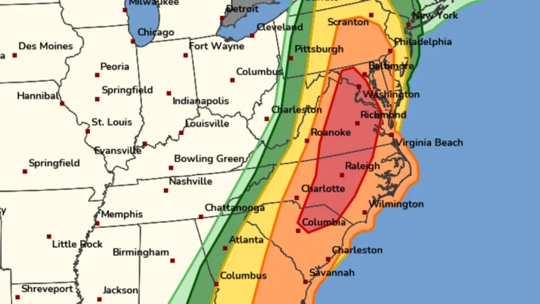
• Rare Moderate Risk (4/5) issued for Mid-Atlantic as severe thunderstorms raise threat of damaging winds and tornadoes

    A Moderate Risk (Level 4 of 5) for severe thunderstorms has been issued across parts of the Mid-Atlantic United States for Monday, March 16, 2026, as a powerful multi-hazard storm threatens over 100 million people across the U.S. Fast-moving storms capable of producing damaging winds and a few strong tornadoes are forecast to develop from the Carolinas into Virginia and Maryland during the afternoon and evening hours. A Moderate Risk is an unusually high severe weather category for the Mid-Atlantic and is not issued often for this region. The National Weather Service office serving the Washington, D.C. area described the setup as a “quite rare Day 2 Moderate Risk area” ahead of the event.

  • Winter weather impacts Appalachians and Mid-Atlantic while severe storm risk expands across parts of Oklahoma and Kansas

    A lifting frontal boundary draped from the southern Plains to the Mid-Atlantic is producing a swath of mixed winter precipitation across the Ohio and Tennessee Valleys on March 2, 2026, while setting the stage for isolated severe thunderstorms in Oklahoma and Kansas on March 3. Winter weather advisories are in effect from Indiana to Pennsylvania, with ice accretion possible across the higher terrain of the Appalachians, according to the Weather Prediction Center.

  • Winter storm warnings and advisories issued across Great Lakes and Northeast U.S.

    Winter Storm Warnings and Winter Weather Advisories were issued across parts of Michigan, New York, New England, and Pennsylvania early Friday, February 20, 2026, with heavy snow and ice forecast to impact travel through February 21. Snowfall totals of 10 to 28 cm (4 to 11 inches) and ice accumulations up to 6 mm (0.25 inches) are expected in warning areas.

  • Snow squalls create hazardous travel conditions across Ohio and Pennsylvania

    Snow squalls continued through the Saturday afternoon, January 17, 2026, across parts of Ohio and Pennsylvania as an Arctic cold front advanced eastward from the Midwest into the Interior Northeast. The National Weather Service warned of sudden whiteout conditions, gusty winds, and rapidly deteriorating visibility, creating dangerous travel for motorists.

  • Winter Storm Warnings in effect for New York, New Jersey, Connecticut, and Pennsylvania, U.S.

    Winter Storm Warnings are in effect for large parts of the northeastern U.S., including New York, New Jersey, Connecticut, and Pennsylvania, from December 26 until midday December 27, 2025. Snow totals of 10–25 cm (4–10 inches) are forecast throughout warning areas, with the heaviest snowfall affecting the Friday evening commute as travel conditions deteriorate rapidly.

  • Lake-effect snow warnings issued across Ohio, Pennsylvania, and New York

    Heavy lake-effect snow is forecast across the eastern Great Lakes region from early Thursday, November 27, through Saturday, November 29, 2025. The National Weather Service (NWS) has issued Lake Effect Snow Warnings for areas in Ohio, Pennsylvania, and New York, with totals reaching up to 50 cm (20 inches) in the most persistent snow bands.