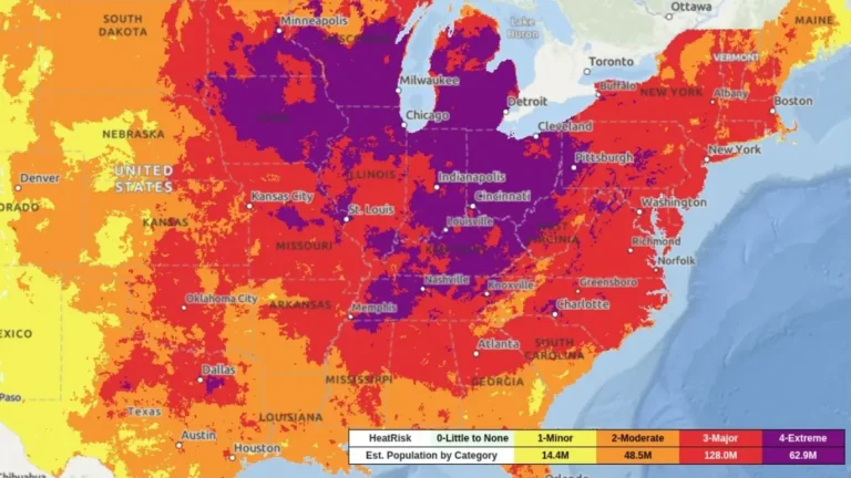
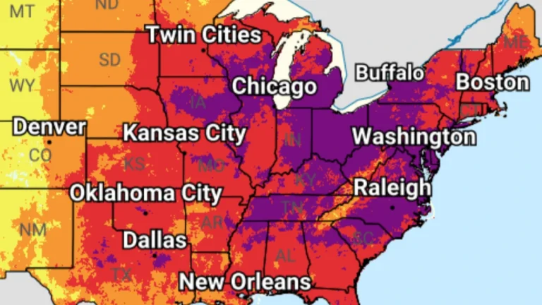
• PDS tornado watch followed by 19 tornado reports, large hail and damaging winds across central U.S.

    A Particularly Dangerous Situtation (PDS) Tornado Watch issued for northeast Kansas and southeast Nebraska on May 18, 2026, was followed by multiple tornado reports, hail up to about 7 cm (2.75 inches), and damaging wind reports across the central U.S. Preliminary SPC storm reports included 19 tornadoes, damage to farm structures, grain bins, trees, and power lines.

  • SPC issues Moderate Risk for strong to intense tornadoes and giant hail across Kansas and Nebraska

    The Storm Prediction Center (SPC) placed portions of central and northeastern Kansas into far southeastern Nebraska under a Moderate Risk for severe thunderstorms on Monday, May 18, 2026. Supercells are forecast to produce all severe hazards, including 5–10+ cm (2–4+ inches) hail and strong to intense tornadoes, mainly from central Kansas into southeastern Nebraska.

  • NWS confirms EF-2 tornado hit Ottawa, Kansas, injuring 3 on April 13

    An EF-2 tornado struck Ottawa in Franklin County, Kansas, between 19:23 and 19:48 CDT on April 13, 2026, damaging homes, businesses, and power infrastructure while injuring three people. The National Weather Service estimated peak winds of 201 km/h (125 mph), with a damage path of 11.75 km (7.3 miles) and a maximum width of 91 m (100 yards).

  • Multiple tornadoes hit Kansas, Minnesota, Iowa and Wisconsin during April 13 severe weather outbreak

    A severe weather outbreak on April 13, 2026, produced at least 14 preliminary tornado reports across Kansas, Minnesota, Iowa, and Wisconsin, with the most serious reported damage in and near Ottawa. No fatalities were immediately reported, but storm surveys were still underway as forecasters warned of additional rounds of severe weather through at least April 16.

  • Red Flag Warnings issued from the Plains to the Southeast under critical fire weather conditions

    Red Flag Warnings are in effect across the Central Plains and Southeast United States on March 28, 2026, as the National Weather Service (NWS) warns of critical fire weather conditions driven by strong winds, low relative humidity, and dry fuels. Wind gusts up to 80 km/h (50 mph) and humidity levels as low as 10–20% are expected to promote rapid fire ignition and spread. Outdoor burning is strongly discouraged across all warned regions.

  • Multiple tornadoes reported across Kansas, Oklahoma, and Texas as severe storms impact southern Plains

    Multiple tornadoes were reported across parts of Kansas, Oklahoma, and Texas on March 5, 2026, as severe thunderstorms moved across the southern Plains. The Storm Prediction Center (SPC) received at least seven tornado reports during the event, with storms causing localized damage and leaving more than 11 000 customers without power as of March 6, according to PowerOutage.US.

  • SPC issues Enhanced Risk for severe storms with large hail and tornado potential across Texas-Oklahoma-Kansas

    Severe thunderstorms capable of producing very large hail, damaging winds, and a few tornadoes are forecast to develop across the Texas Panhandle, western Oklahoma, and southern Kansas late on March 5, 2026. The National Weather Service (NWS) Storm Prediction Center (SPC) has issued an Enhanced Risk for the region as atmospheric conditions become favorable for supercell development along a dryline during the late afternoon and evening.