
Potential Tropical Cyclone One-C moving toward Hawaii, heavy rain, strong winds and dangerous surf forecast
Potential Tropical Cyclone One-C was moving toward the Hawaiian Islands on August 13, 2026 with 1-minute sustained winds of 65 km/h (40 mph). The system is forecast to continue strengthening during its approach. Heavy rainfall, strong winds and dangerous surf were forecast for parts of Hawaii starting late August 14. Meanwhile Tropical Storm Hernan that formed far west of Baja California, was forecast to weaken.
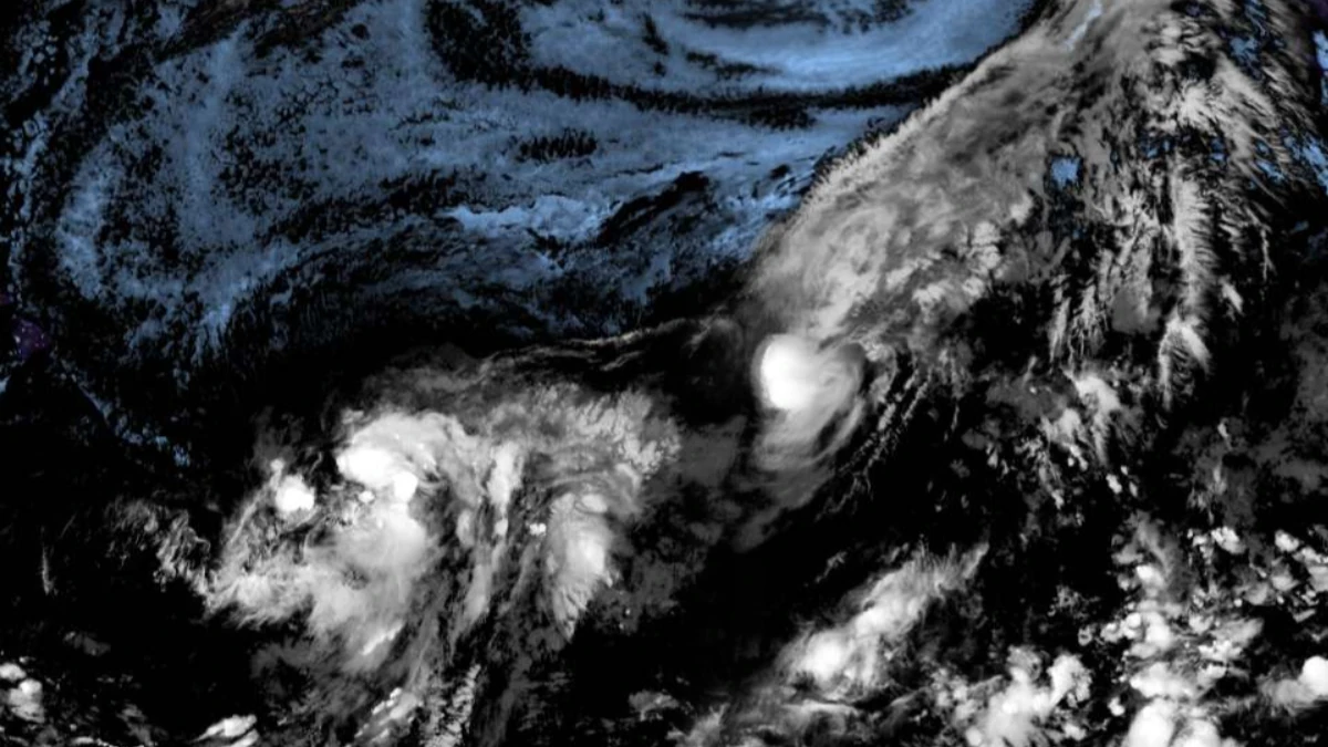
Satellite image of PTC one c and Tropical Storm Hernan at 1250 UTC on August 13, 2026. Credit: NOAA/GOES-19, Zoom Earth, The Watchers
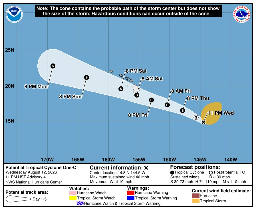
At 23:00 HST on August 12 (09:00 UTC on August 13), Potential Tropical Cyclone One-C was located approximately 1 250 km (775 miles) east-southeast of Hilo, Hawaii. 1-minute sustained winds were 65 km/h (40 mph), and the system was moving west at 17 km/h (10 mph), according to the National Hurricane Center (NHC) and Central Pacific Hurricane Center (CPHC).
NHC forecast the disturbance to become a tropical storm and strengthen while moving west-northwestward toward the Hawaiian Islands. Heavy rainfall is forecast to begin affecting the Big Island on Friday before spreading westward across the island chain during the weekend. The rainfall may produce life-threatening flooding and mudslides, especially over steep terrain.
High winds and dangerous surf are also among the primary hazards for Hawaii. The exact location and magnitude of wind impacts remained dependent on the developing circulation, track and intensity as the system approached the islands.
The NHC intensity forecast increased One-C from 65 km/h (40 mph) to 95 km/h (60 mph) by 06:00 UTC on August 15 and 100 km/h (65 mph) by 18:00 UTC on August 15 as it moved closer to the Hawaiian Islands.
Scatterometer data showed One-C’s circulation becoming more circular, but the strongest winds remained displaced well northeast of the estimated center and organized convection was still insufficient for tropical-cyclone classification.
NHC described the initial motion as uncertain and said confidence in how close the center would pass to Hawaii would remain low until a better-defined center developed.
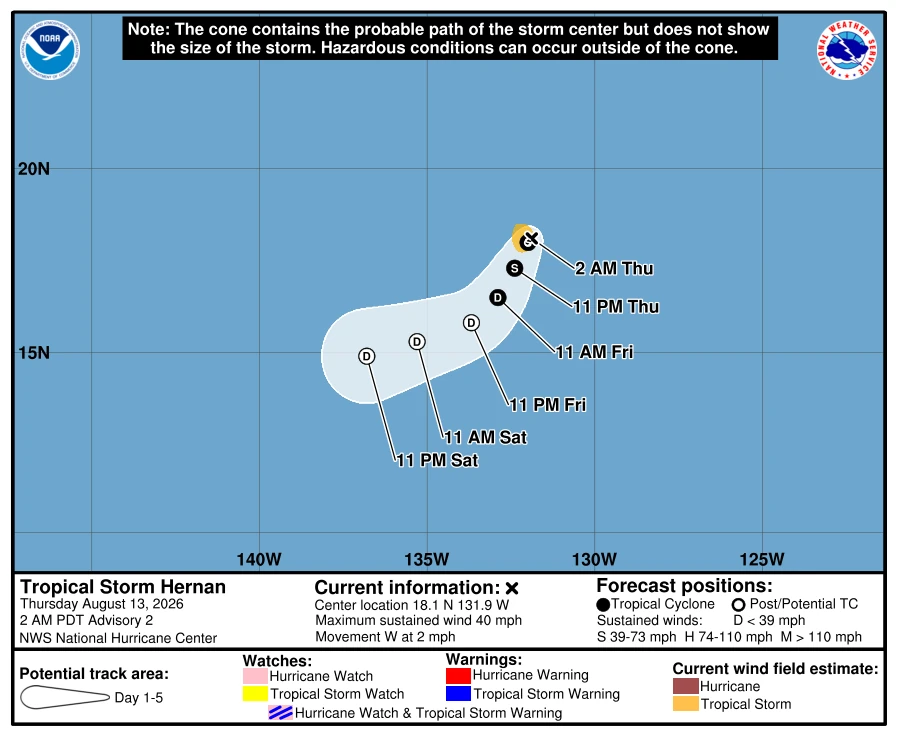
Farther east, Tropical Depression Eight-E strengthened into Tropical Storm Hernan by 02:00 PDT (09:00 UTC) on August 13. NHC centered Hernan near, about 2 350 km (1 460 miles) west of the southern tip of Baja California, with 1-minute sustained winds of 65 km/h (40 mph) and a minimum central pressure of 1 006 hPa.
Hernan was moving slowly west at 4 km/h (2 mph), and tropical-storm-force winds extended outward up to 65 km (40 miles) from its center. No coastal watches or warnings were in effect, and NHC listed no hazards affecting land.
NHC forecast Hernan to make a gradual turn toward the southwest during the following day or so. Minor additional strengthening remained possible through August 13, but weakening was forecast to begin Friday, with the storm capable of degenerating into a remnant low within about 48 hours.
References:
1 Potential Tropical Cyclone One-C Public Advisory Number 4 – NHC/CPHC – August 13, 2026
2 Potential Tropical Cyclone One-C Forecast Discussion Number 4 – National Hurricane Center / Central Pacific Hurricane Center – August 13, 2026,
3 Tropical Storm Hernan Public Advisory Number 2 – NHC – August 13, 2026, 09:00 UTC

Rishav Kothari is Editor-in-Chief of The Watchers, where he runs the newsroom and covers earthquakes, volcanoes, severe weather and space weather.
Published in the last 24 hours
- The Leonid meteor shower peaks on the night of November 17, exactly 60 years after the 1966 storm, when some observers reported meteors falling at up to 40 a second, though this year’s show should be closer to 15 an hour
- When Arctic air reached South Florida in January 2020, Miami fell to 40°F and the National Weather Service warned residents to watch for cold-stunned iguanas dropping out of the trees Epicenter
- In May 2024, the strongest solar storm in 20 years put northern lights over the southern US, and across the Plains, GPS-guided tractors built to plant within an inch drifted about 10 feet off their rows Epicenter
- In 1943, a flight instructor in Texas flew a two-seat training plane into the eye of a hurricane because he was curious, then landed and took the base weatherman up for a second pass Epicenter
