
Typhoon Champi leaves one dead and hundreds injured as recovery continues in Taiwan
Recovery operations continued in Taiwan on October 25, 2026, after Typhoon Champi brought strong winds, heavy rain, and high waves from October 22 to 24. The Central Emergency Operations Center’s final October 24 briefing reported one death and 634 injuries, while agricultural losses rose to NT$193.32 million by the following afternoon.

Damage caused by Typhoon Champi in Taiwan on October 24, 2026. Credit: Taiwanplus
The Central Emergency Operations Center (CEOC) reported at its 21:00 LT (13:00 UTC) briefing on October 24 that 508 of the injured people had been discharged from medical care, according to United Daily News.
The fatality occurred in Liuqiu Township, Pingtung County, where a man was swept away by waves from a beach on October 22, according to CEOC information reported by the Central News Agency (CNA). Most reported injuries were minor cuts and bruises.
Evacuations covered 12 cities and counties, including 1 649 people in New Taipei and 1 512 in Hsinchu County. The total included 140 people moved from areas exposed to a landslide-dammed lake along Wanli Creek in Hualien County.

Of the 9 676 damage reports, 7 402 had been resolved and 2 274 still required action at the October 24 briefing. Fallen trees, downed power lines, damaged signs, and other infrastructure accounted for many reports.
More than 350 000 electricity customers experienced outages during the storm. In an October 25 morning update reported by United Daily News, New Taipei Mayor Hou Yu-ih said 4 085 customers in the city still needed power restored, mainly along the northeast coast and northern shoreline.
Taipower’s Yilan branch subsequently said it had restored electricity to all affected residential customers in its service area by 16:00 LT (08:00 UTC) on October 25. More than 30 000 customers there had experienced outages during the storm.

The Ministry of Agriculture’s assessment at 17:00 LT (09:00 UTC) on October 25 put agricultural and related private-facility losses at NT$193.32 million, up from NT$151.42 million that morning. Affected cropland increased to 3 205 ha (7 920 acres), equivalent to 767 ha (1 895 acres) of complete production loss.
Yunlin accounted for approximately 65% of the preliminary national loss, followed by Miaoli at 13%. Garlic remained the most heavily affected crop by value, followed by peanuts, onions, sweet corn and citrus; the ministry said assessments remained ongoing.
The Central Weather Administration (CWA) ended its land warning at 14:30 LT (06:30 UTC) on October 24 and its sea warning at 20:30 LT (12:30 UTC). The storm passed close to Nanfang’ao in Yilan County, but CWA determined that its center did not make landfall.
A separate wave incident was reported at Bisha Fishing Harbor in Keelung after the warnings ended. CNA’s October 25 report, updated at 15:36 LT (07:36 UTC), said rescuers were searching for a man swept into the sea while fishing with his son on the evening of October 24; the boy was injured and taken to hospital.

Rainfall from October 22 through 20:30 LT (12:30 UTC) on October 24 reached 652 mm (25.7 inches) at Taipingshan in Yilan County. Mountain locations in Hsinchu and Taoyuan each recorded more than 500 mm (19.7 inches).
CWA reported gusts of force 10 or stronger in approximately 87 townships. Automatic stations at Sandiao Cape in New Taipei, Datunshan in Taipei and Taoyuangu in Yilan recorded force-17 gusts.
Wave heights reached 10.6 m (34.8 feet) at Lanyu, 9.9 m (32.5 feet) at Longdong and 9.4 m (30.8 feet) at Pengjiayu. CWA said the Lanyu and Pengjiayu observations were the highest since the respective stations began operating.
Domestic flights began resuming during the afternoon of October 24 as weather conditions allowed, but some island transport links remained disrupted on October 25. Maritime and Port Bureau notices suspended Fugang–Lanyu ferries on October 25–26 because the Fugang port channel was obstructed, while Green Island services were rerouted through Chenggong with some cancellations.
The central emergency operations center stood down after its October 24 evening briefing, with recovery work returning to ministries and local authorities. CWA’s October 25 forecast called for occasional rain in eastern Taiwan, locally heavier in Hualien and Taitung, while northern conditions improved.
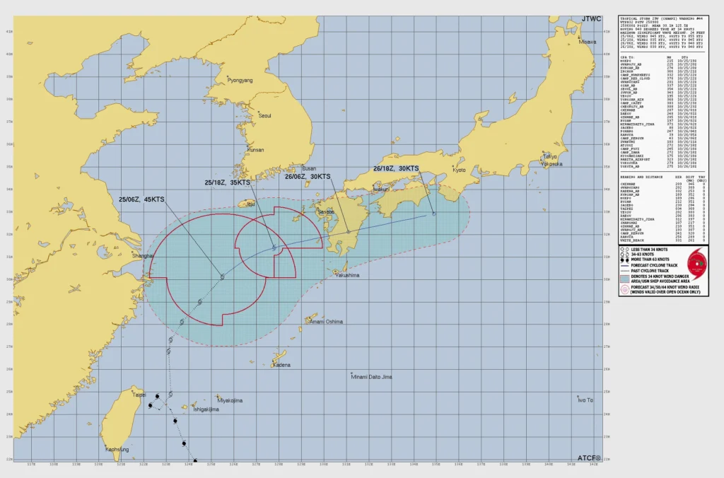
Farther northeast, Champi remained a tropical storm over the East China Sea. In Warning 44, issued at 09:00 UTC on October 25, the Joint Typhoon Warning Center (JTWC) placed its center near 30.1°N, 125.5°E at 06:00 UTC, with maximum one-minute sustained winds of 83 km/h (52 mph), gusts to 102 km/h (63 mph) and a minimum central pressure of 995 hPa.
The storm was moving northeast at 26 km/h (16 mph). JTWC estimated a significant wave height of 7.3 m (24 feet) near the cyclone over open water.
Satellite imagery showed a fully exposed low-level circulation with little thunderstorm activity. JTWC said dry air, moderate wind shear, and sea-surface temperatures of 25–26°C (77–79°F) were unfavorable for renewed tropical strengthening.
JTWC forecast the weakening circulation to reach southern Kyushu around October 26 and become extratropical, with sustained winds falling to about 56 km/h (35 mph) by 06:00 UTC that day. The agency cautioned that the circulation could instead break down into a trough before completing that transition.
References:
1 CEOC tenth work briefing – NFA – October 24, 2026.
2 Champi casualties and fatality circumstances – CNA – October 24, 2026.
3 Electricity restored to affected residential customers in Yilan – Taipower Yilan Branch – October 25, 2026
4 Tropical Storm 29W (Champi), Warning 44 – JTWC – October 25, 2026

Rishav Kothari is Editor-in-Chief of The Watchers, where he runs the newsroom and covers earthquakes, volcanoes, severe weather and space weather.
Published in the last 24 hours
- The Leonid meteor shower peaks on the night of November 17, exactly 60 years after the 1966 storm, when some observers reported meteors falling at up to 40 a second, though this year’s show should be closer to 15 an hour
- When Arctic air reached South Florida in January 2020, Miami fell to 40°F and the National Weather Service warned residents to watch for cold-stunned iguanas dropping out of the trees Epicenter
- In May 2024, the strongest solar storm in 20 years put northern lights over the southern US, and across the Plains, GPS-guided tractors built to plant within an inch drifted about 10 feet off their rows Epicenter
- In 1943, a flight instructor in Texas flew a two-seat training plane into the eye of a hurricane because he was curious, then landed and took the base weatherman up for a second pass Epicenter
