
SPC warns of Critical fire weather conditions across eastern Montana and west-central North Dakota
The NWS Storm Prediction Center (SPC) issued a Critical fire weather forecast for parts of eastern Montana into west-central North Dakota valid from 12:00 UTC on May 11 through 12:00 UTC on May 12, 2026, as multiple National Weather Service offices warned that strong winds, low humidity, dry fuels, and frontal wind shifts would support rapid wildfire spread across parts of the northern and central Plains.
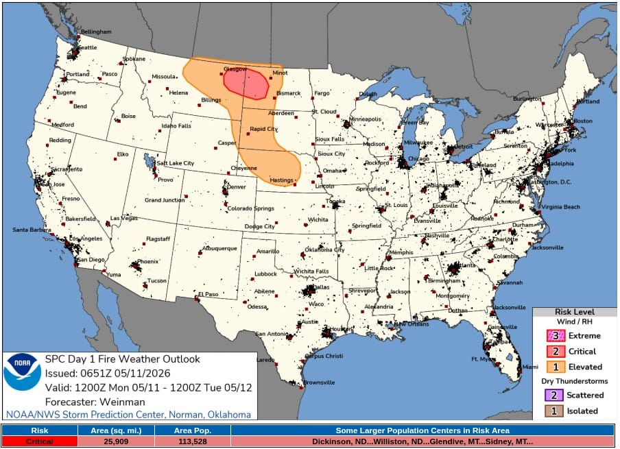
SPC Day 1 Fire Weather Outlook valid 24 hours to 12:00 UTC on May 12, 2026. Credit: NWS/SPC
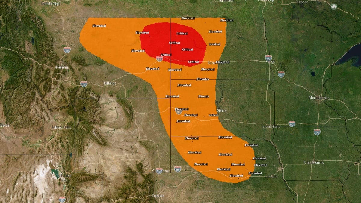
The SPC identified the greatest concern across parts of eastern Montana and west-central North Dakota, where sustained west-northwesterly winds of 30 to 40 km/h (20 to 25 mph), gusts over 55 km/h (35 mph), and relative humidity values of 20 to 25% were forecast during peak daytime heating.
Population centers within the Critical risk area included Dickinson and Williston in North Dakota, along with Glendive and Sidney in Montana.
According to the SPC forecast discussion, a robust midlevel trough and accompanying 70-kt jet streak were forecast to advance eastward across Montana and North Dakota along the northern periphery of a large-scale ridge centered over the western United States.
Downslope flow trajectories and daytime heating are expected to support deep boundary-layer mixing and downward transport of stronger winds to the surface.
The overlap of strong winds, low relative humidity, and receptive fuels is forecast to produce Critical fire weather conditions across the eastern Montana to west-central North Dakota corridor. Farther south into portions of the central Plains, elevated to locally Critical conditions were also forecast as temperatures climb to around 27 to 32°C (lower and middle 80s°F), with relative humidity values of 15 to 20%.
NWS Glasgow said northeast Montana fire weather zones 120, 122, 134, 135, 136, and 137 are under a Red Flag Warning from 11:00 to 20:00 MDT on May 11, with northwest winds of 30 to 55 km/h (20 to 35 mph), gusts up to 70 km/h (45 mph), and humidity as low as 15%.
The warning cover areas including the Fort Peck Reservation, Daniels, Roosevelt, Sheridan, Dawson, McCone, Prairie, Richland, Wibaux, Valley, Phillips, Petroleum, and Garfield counties.
NWS Billings maintained a Red Flag Warning from 09:00 to 21:00 MDT for fire weather zones 130, 132, and 133 in southeast Montana and northwest South Dakota. The forecast calls for northwest winds of 25 to 40 km/h (15 to 25 mph), gusts of 50 to 65 km/h (30 to 40 mph), humidity as low as 15%, and temperatures up to 28°C (83°F), with the most critical areas mainly along and north of Interstate 94 and US Highway 12.
NWS Bismarck issued Red Flag Warnings covering western and most of central North Dakota, including the James River Valley, from 11:00 CDT / 10:00 MDT to 22:00 CDT / 21:00 MDT on May 11. The warning includes southwest winds of 40 to 55 km/h (25 to 35 mph), gusts up to 70 km/h (45 mph), relative humidity as low as 15%, and a shift to northwest winds during the afternoon and evening.
The office also said there’s a low chance of isolated showers and thunderstorms over parts of western and central North Dakota, which could produce stronger erratic wind gusts.
Red Flag Warnings also cover large parts of South Dakota. NWS Rapid City warned that the western South Dakota plains would see temperatures of 29 to 35°C (85 to 95°F), minimum relative humidity of 10 to 20%, and wind gusts of 50 to 65 km/h (30 to 40 mph), with a dry cold front producing a sudden wind shift from south to northwest between 14:00 and 21:00 MDT.
NWS Aberdeen issued warnings for Hughes, Stanley, Jones, and Lyman counties, where winds were forecast to gust up to 55 km/h (35 mph), and humidity could fall as low as 19 to 23%.
NWS North Platte is warning of critical fire weather conditions across western and north-central Nebraska from noon CDT / 11:00 MDT to 22:00 CDT / 21:00 MDT. The forecast calls for southwest winds of 25 to 40 km/h (15 to 25 mph), gusts up to 55 km/h (35 mph), relative humidity falling to 10 to 20%, and temperatures reaching around 31 to 34°C (upper 80s to lower 90s°F).
NWS Hastings issued a Red Flag Warning for portions of south-central Nebraska, where southwest winds of 25 to 30 km/h (15 to 20 mph), gusts up to 50 to 55 km/h (30 to 35 mph), and humidity as low as 15 to 20% were forecast.
The SPC outlook estimated that the Critical fire weather area covered approximately 67 100 km2 (25 900 mi2), including an exposed population of roughly 113 530 people.
References:
1 Day 1 Fire Weather Outlook – NWS/SPC – May 11, 2026
2 Red Flag Warnings – NWS – May 11, 2026
I'm a dedicated researcher, journalist, and editor at The Watchers. With over 20 years of experience in the media industry, I specialize in hard science news, focusing on extreme weather, seismic and volcanic activity, space weather, and astronomy, including near-Earth objects and planetary defense strategies. You can reach me at teo /at/ watchers.news.
Commenting rules and guidelines
We value the thoughts and opinions of our readers and welcome healthy discussions on our website. In order to maintain a respectful and positive community, we ask that all commenters follow these rules.