
Two dead after EF2 and EF1 tornadoes impact Wise and Parker counties, Texas
At least two people died in North Texas after EF2 and EF1 tornadoes struck Wise and Parker counties on April 25, 2026.
At least two people have died in parts of Texas after tornadoes swept through Runaway Bay and Springtown on April 25.
The Springtown tornado in Parker County was rated an EF1 with maximum winds of approximately 169 km/h (105 mph). It touched down at 21:38 LT and lifted off about 12 minutes later at 22:10 LT.
Parker County Emergency Services responded to more than 70 calls and confirmed at least one fatality amid the severe weather overnight on April 25.
The fatality was associated with severe winds from the tornado since it was outside the twister’s track, according to the National Weather Service (NWS).
“Damage assessments continue; the Parker County Office of Emergency Management is working with local and state officials for resource requests as needed and a disaster declaration,” said Parker County Emergency Services.
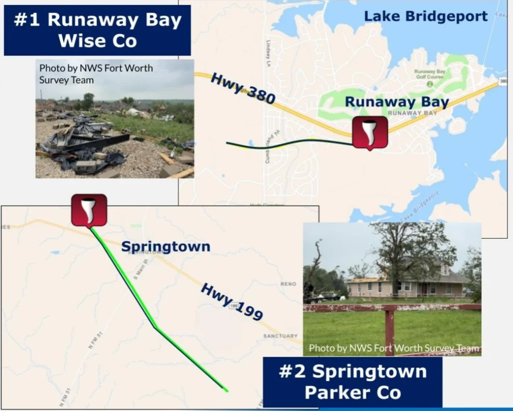
Meanwhile, the Runaway Bay tornado in Wise County was rated an EF2 with maximum winds of 209 km/h (130 mph). It touched down at around 21:03 local time (LT) and lifted off at approximately 09:07 LT.
A local state of disaster has been declared and will remain under it for at least seven days, unless the situation requires otherwise.
Severe weather conditions persisted across the region as thunderstorms developed in a highly unstable environment, contributing to damaging winds and localized impacts beyond the tornado paths.
The Storm Prediction Center (SPC) has issued a Moderate Risk (Level 4 of 5) for severe thunderstorms on April 27 across parts of Missouri into Illinois, highlighting the potential for a more significant outbreak of severe weather.
Forecasters expect numerous severe thunderstorms from the Mid-Mississippi Valley into the Lower Ohio Valley and Mid-South through the evening, with a threat for multiple strong to intense tornadoes rated EF3 or higher, along with widespread damaging winds and large to very large hail reaching up to 7.6 cm (3 inches) in diameter.
A mid- to upper-level trough moving across the central United States is supporting this setup, with a strengthening low-level and mid-level jet supporting strong wind shear across the warm sector. This environment favors the development of discrete supercells capable of producing tornadoes during the afternoon and evening hours.
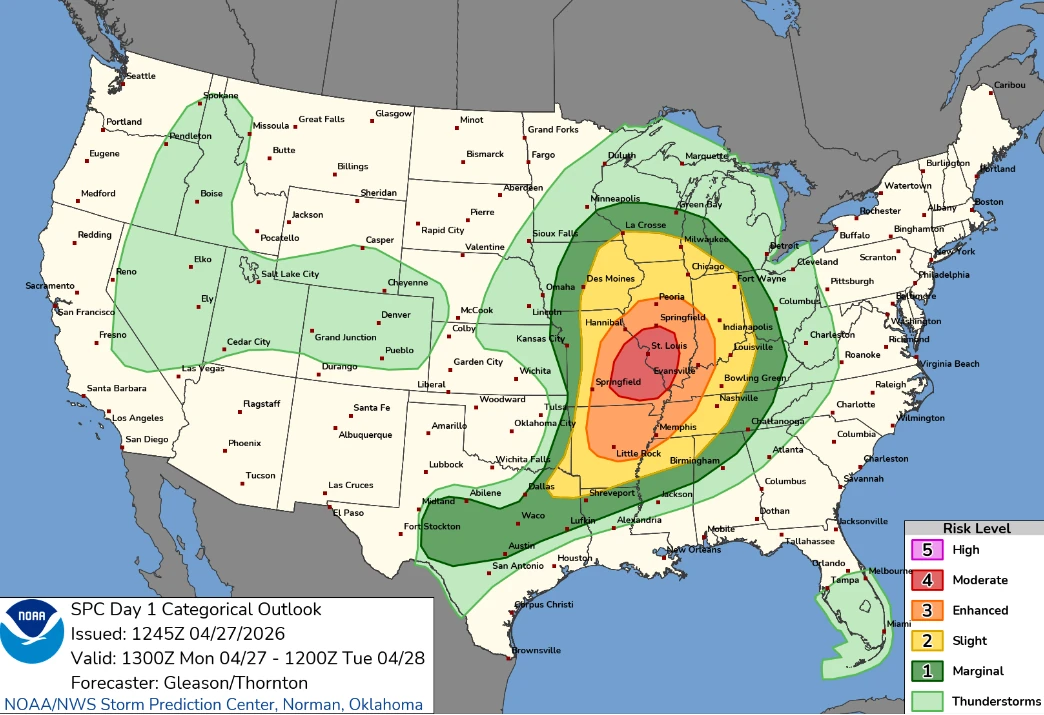
Initial storm development is expected between 19:00 and 21:00 UTC across parts of Missouri and the Mid-South ahead of a surface cold front, with storms becoming increasingly organized and potentially consolidating into clusters later in the evening.
The strongest tornado potential is expected along and near an effective warm front extending across Missouri into Illinois, where atmospheric instability and wind shear overlap. Additional tornado risk may extend southward into Arkansas and Tennessee, although confidence decreases with southward extent.
Storms are expected to evolve into linear segments capable of producing widespread damaging winds across the Lower Ohio Valley into the evening and overnight hours, while embedded circulations may continue to support tornado development.
Farther south, isolated to scattered supercells are possible from the ArkLaTex region into Texas, where strong heating and moisture return along a retreating dryline may support large hail and damaging winds, although storm coverage and persistence remain uncertain.
Featured image credit: Texas Storm Chasers

I am an Assistant Editor and Severe Weather & Science Journalist at The Watchers, specializing in real-time severe weather coverage, geophysical event reporting, and research-driven scientific analysis. You can reach me at rishav(at)watchers(.)news.
Commenting rules and guidelines
We value the thoughts and opinions of our readers and welcome healthy discussions on our website. In order to maintain a respectful and positive community, we ask that all commenters follow these rules.