
Strong tornadoes, large hail and damaging winds expected from Plains to Great Lakes on April 17
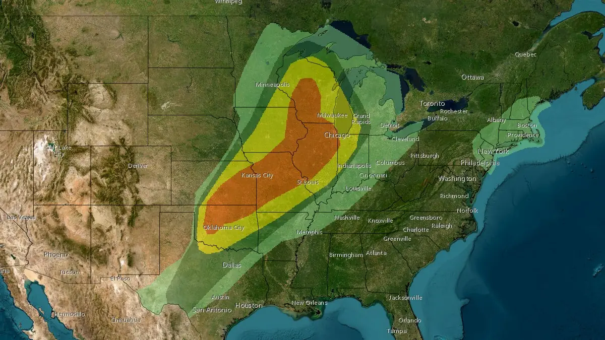
A multi-phase severe weather event is expected to impact the central United States on April 17, 2026, from northern Oklahoma to Wisconsin, with an Enhanced Risk of severe storms in place. Initial supercells may produce strong tornadoes and large hail before transitioning into an organized system capable of widespread damaging winds and localized flash flooding.
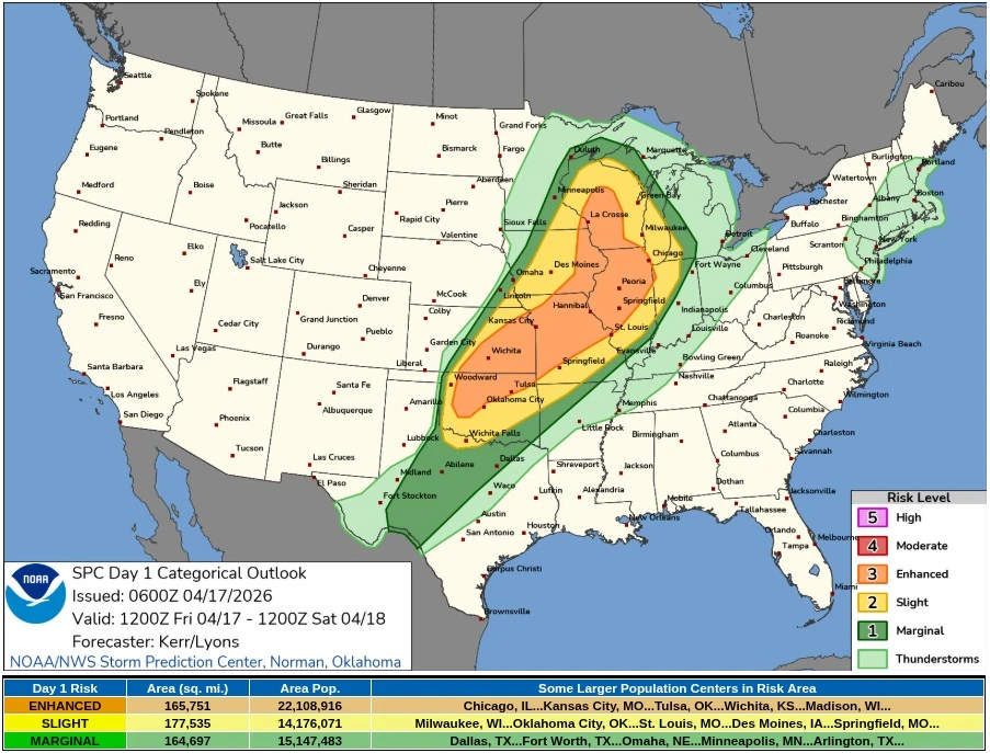
Convective outlook valid 12:00 UTC on April 17 to 12:00 UTC on April 18, 2026. Credit: SPC
Widespread severe thunderstorm development is forecast across a large portion of the central United States on April 17, as a dynamic spring weather pattern supports organized convective activity from the central and southern Plains into the Midwest and Great Lakes. The Storm Prediction Center (SPC) has issued an Enhanced Risk (level 3/5) across a corridor extending from northern Oklahoma through Kansas, Missouri, Illinois, and into Iowa and Wisconsin.
The severe weather threat is expected to evolve in multiple phases during the day. By early to mid-afternoon, discrete supercells are likely to develop along a pre-frontal corridor of strong instability extending from the central Plains into the Upper Mississippi Valley.
Within this environment, steep lapse rates and strengthening low-level wind fields will support thunderstorms capable of producing large hail exceeding 5 cm (2 inches) in diameter and a few strong tornadoes, particularly from eastern Iowa into southern and central Wisconsin.
The tornado risk is associated with strengthening low-level shear and enlarging hodographs ahead of an advancing cold front. A corridor of enhanced surface pressure falls moving from western Iowa into western Wisconsin is expected to coincide with increasing boundary-layer destabilization, providing a window for more organized supercell structures capable of producing tornadoes before storm interactions increase.
Across the central and southern Plains into the lower Missouri Valley, uncertainty remains regarding the timing of frontal undercutting of unstable air. However, storms developing from south-central Kansas into northwestern Missouri during the afternoon may initially produce very large hail and a few tornadoes before transitioning into a more linear convective mode.
By late afternoon into the evening, thunderstorms are forecast to grow upscale into one or more mesoscale convective systems. As this transition occurs, the primary hazard is expected to shift toward widespread damaging wind gusts.
Strengthening rear-inflow jets and deep-layer flow of approximately 65-75 km/h (40-45 mph) will support organized wind-producing segments, with the potential for extensive swaths of severe wind damage across parts of the lower Missouri Valley into the Midwest.
Embedded mesovortices within the evolving convective line may continue to pose a risk for brief tornadoes during the evening hours. These features can develop along the leading edge of the gust front and contribute to localized areas of enhanced wind damage.
In addition to severe convective hazards, heavy rainfall is forecast to accompany thunderstorms, with hourly rainfall rates of 25-50 mm (1-2 inches) possible. This raises the potential for scattered flash flooding from the central Plains into the Great Lakes, particularly in areas where soil conditions are already saturated.
Parts of Missouri, Kansas, Arkansas, and Oklahoma are considered more sensitive to additional rainfall, increasing the likelihood of rapid runoff and localized flooding.
The broader synoptic pattern driving this event includes an upper-level trough progressing eastward from the western United States, accompanied by multiple embedded shortwave disturbances. At the surface, a cold front advancing southward from the northern Plains and a trailing dryline across the southern Plains are providing the necessary lift and convergence for thunderstorm development. Moisture advection from the Gulf of Mexico is maintaining a humid and unstable air mass ahead of the front.
A wintry mix and light to moderate snowfall are expected north and west of the surface low track across parts of the Upper Midwest and Great Lakes, while the northern and central Rockies may also experience accumulating snow under the base of the upper trough.
Meanwhile, critical fire weather conditions are forecast across portions of the southern High Plains, where strong winds and very low humidity west of the dryline are expected to support rapid fire spread.
A significant temperature shift will follow the passage of the cold front. Above-average temperatures across the central and eastern United States, with highs reaching 27-32°C (80-90°F) on April 17, are expected to drop sharply into the 4-21°C (40-70°F) range by April 18 as cooler air spreads eastward.
References:
1 Day 1 Convective Outlook – NWS/SPC – Issued at 06:00 UTC on April 17, 2026
2 Short Range Forecast Discussion – NWS/WPC – Issued at 07:52 UTC on April 17, 2026
I'm a dedicated researcher, journalist, and editor at The Watchers. With over 20 years of experience in the media industry, I specialize in hard science news, focusing on extreme weather, seismic and volcanic activity, space weather, and astronomy, including near-Earth objects and planetary defense strategies. You can reach me at teo /at/ watchers.news.
Commenting rules and guidelines
We value the thoughts and opinions of our readers and welcome healthy discussions on our website. In order to maintain a respectful and positive community, we ask that all commenters follow these rules.