
Multi day storm event forecast across central and southern United States, March 4-6
A multi-day storm event is forecast to unfold across the central and southern United States, with the Storm Prediction Center issuing a slight to enhanced risk of severe thunderstorms across the Southern and Central Plains from March 4 to 6, 2026.
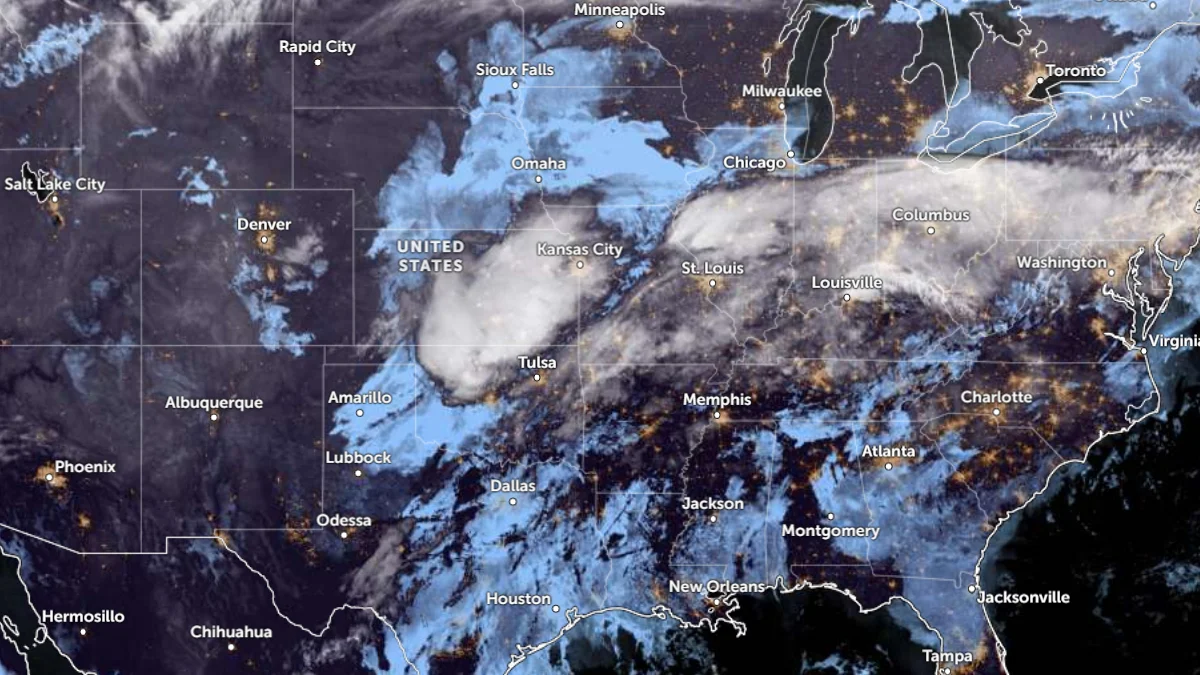
Satellite image of central and eastern U.S.A at 11:00 UTC on March 4, 2026. Credit: NOAA/GOES-19, Zoom Earth, The Watchers
A slow-moving frontal system is forecast to bring widespread showers and thunderstorms to the Southern Plains and the Ohio and Tennessee Valleys between March 4 and 6.
Multiple storm waves developing along the front will generate periods of moderate to heavy rain, leading to an increased risk of localized flash flooding across Kentucky, Tennessee, southern Illinois, and northern Mississippi.
The front is expected to shift slowly eastward toward the Appalachians by March 5 and 6, bringing decreasing rainfall intensity as drier air moves in from the west.
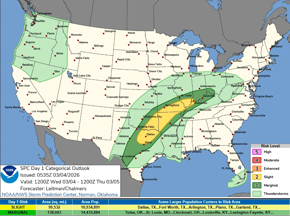
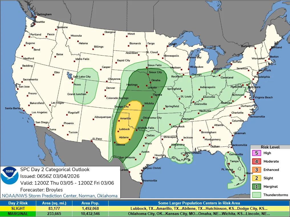
The Storm Prediction Center (SPC) has issued a Slight Risk for severe thunderstorms on March 4, covering parts of northeast Texas, eastern Oklahoma, southern Missouri, and western Kentucky. Meanwhile, A Slight Risk of Severe thunderstorms extends from Texas to Kansas on March 5.
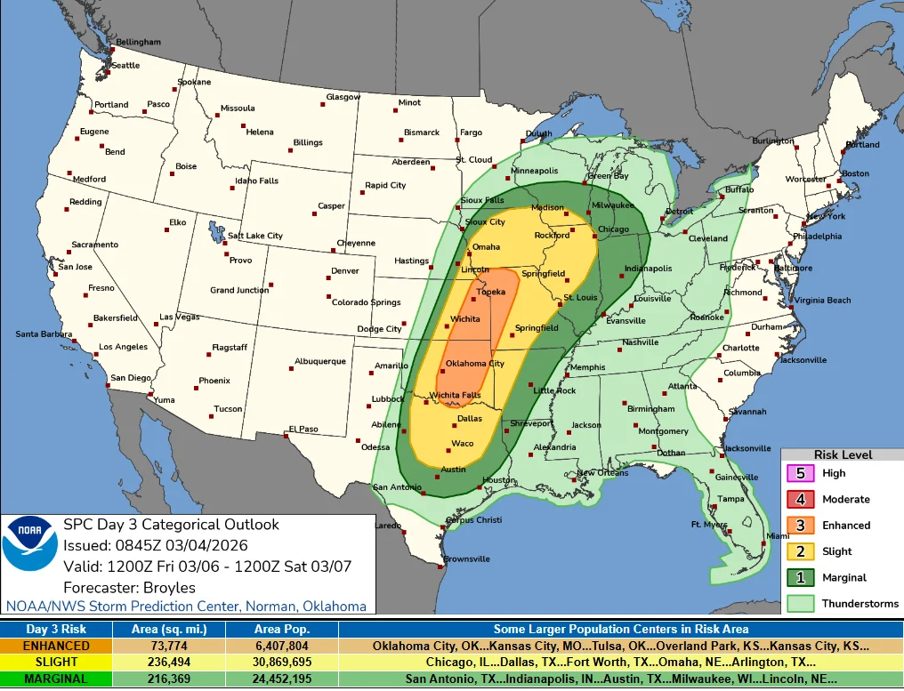
An Enhanced Risk of severe thunderstorms has been issued for parts of the Southern and Central Plains into the lower and mid-Missouri Valley on March 6.
Damaging winds and hail are possible, but the main hazard for most locations remains heavy rainfall, with a small chance for isolated tornadoes embedded within the larger convective system.
Rainfall totals of 25 to 75 mm (1–3 inches) are forecast from the Southern Plains into the Ohio Valley, with isolated totals of 100 mm (4 inches) as storms repeatedly track over the same areas.
High flood risk remains across the Ohio and Tennessee Valleys, including Paducah, Kentucky, and Nashville, Tennessee.
Soils in the region are already saturated from recent storms, increasing the risk of rapid runoff and flooding of low-lying roads, creeks, and urban drainage systems.

I am an Assistant Editor and Severe Weather & Science Journalist at The Watchers, specializing in real-time severe weather coverage, geophysical event reporting, and research-driven scientific analysis. You can reach me at rishav(at)watchers(.)news.
Real time IMPC TEC looks normative at this time, local night.
They certainly nailed this right. Super active.
Wild one, look at how this setup emerged with the tectonic swarm around Warm Springs NM. Nature sure is trying to rebalance some energy.
Any interesting propagation over H.F. in the region last few days?