
Heavy snow, coastal flooding, and power outages forecast during major nor’easter affecting the eastern U.S.
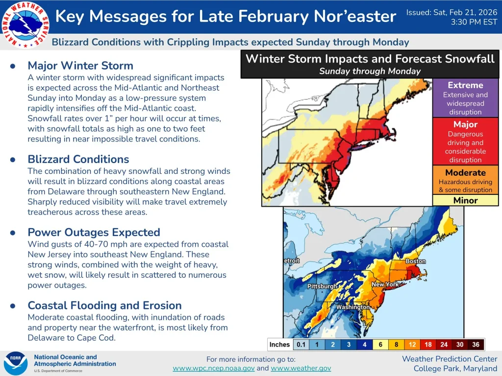
A rapidly intensifying coastal low is forecast to produce blizzard conditions from the Mid-Atlantic into the Northeast U.S. from February 22 to 23, 2026, bringing 30-60 cm (1-2 feet) of heavy snow, wind gusts up to 110 km/h (70 mph), and moderate coastal flooding.
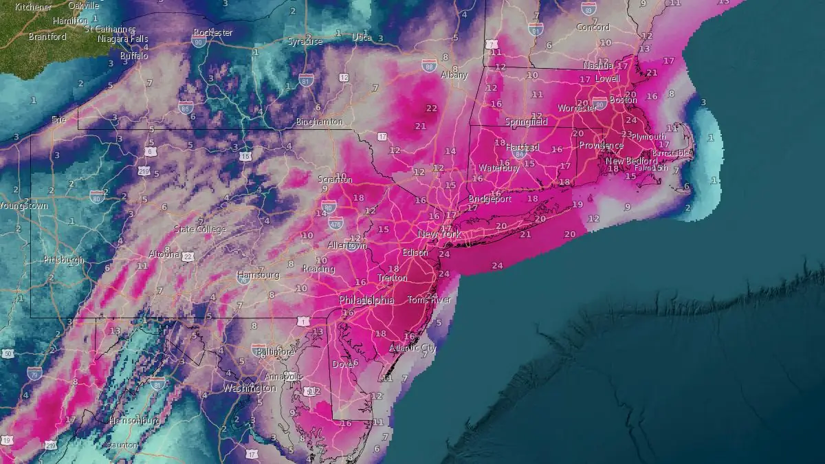
Total new snow ending 07:00 EST on February 24, 2026. Credit: NOAA/NWS
Key takeaways:
- A rapidly deepening coastal low is forecast to bring a major winter storm to the Mid-Atlantic and Northeast U.S. from Sunday through Monday. The Weather Prediction Center expects rapid cyclogenesis off the Mid-Atlantic coast as the system tracks northeast toward southern New England.
- Heavy snow of 30–60 cm (1–2 feet) is expected, with snowfall rates occasionally exceeding 25 mm (1 inch) per hour. Blizzard warnings are in effect from Delaware through southern New England, including New York City. Visibility may fall below 400 m (0.25 miles) at times, producing whiteout conditions and hazardous travel.
- Strong winds gusting up to 110 km/h (70 mph) will combine with heavy, wet snow to generate blizzard conditions. The weight of the snow and high wind load are likely to cause scattered to numerous power outages and tree damage across the affected corridor.
- Moderate coastal flooding with a storm surge of 0.6–1.2 m (2–4 feet) is possible from Delaware Bay to Cape Cod. Onshore flow and high tides may inundate low-lying roads and waterfront properties, with localized erosion possible.
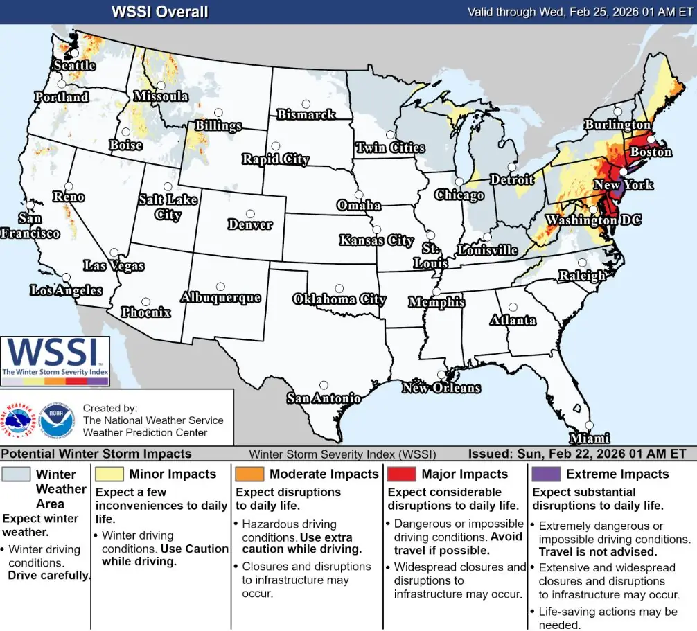
- Travel is expected to become extremely difficult to impossible along the I-95 corridor from Sunday night into Monday. The Winter Storm Severity Index (WSSI) indicates major to extreme impacts across the Northeast urban corridor, including Washington D.C., Philadelphia, New York City, and Boston, where significant transportation and power disruptions are anticipated.
A major winter storm is forecast to impact the Mid-Atlantic and Northeast United States from Sunday, February 22, into Monday as a low-pressure system rapidly deepens off the Atlantic coast.
According to the Weather Prediction Center (WPC) forecast issued at 19:00 EST on February 21, the storm will produce heavy snowfall rates above 25 mm (1 inch) per hour and wind gusts reaching 65–110 km/h (40–70 mph). Snow will spread from the Central Appalachians to Maine on Sunday and continue through Monday evening.
The system is developing from a southern Plains trough interacting with Gulf moisture and a strong upper-level jet streak, expected to undergo rapid cyclogenesis near the southern Mid-Atlantic coast.
The National Weather Service (NWS) forecasts a central pressure drop of more than 24 hPa in 24 hours, a bomb cyclone threshold, as the system moves northward toward southern New England by Monday evening.
Heavy wet snow combined with strong onshore winds is expected to create blizzard conditions in coastal zones from Delaware through Massachusetts. Snow totals of 30–60 cm (1–2 feet) are forecast across southern New York, Connecticut, and Massachusetts, with locally higher accumulations in eastern Pennsylvania and coastal New England.
Travel is expected to be extremely difficult to impossible at times, with visibility below 400 m (0.25 miles) and whiteout conditions along the I-95 corridor.
The NWS has issued Blizzard Warnings for parts of Delaware, southern New Jersey, New York City, Long Island, Connecticut, and southern New England. Winter Storm Warnings cover a broader area across the Mid-Atlantic and inland Northeast, while high wind warnings extend along the immediate coast.
Moderate coastal flooding is forecast from Delaware Bay to Cape Cod as strong onshore flow coincides with high tide cycles. Storm surge values of 0.6–1.2 m (2–4 feet) are possible in low-lying shore communities.
Forecasters warn that wet snow accumulation on trees and power lines, combined with gusts exceeding 90 km/h (55 mph), will likely cause scattered to numerous power outages and structural strain on aging distribution infrastructure.
Emergency management agencies have advised residents to prepare for the potential loss of electricity and limited road access through Monday.
The Weather Prediction Center Winter Storm Severity Index (WSSI) shows major to extreme impacts for the entire Northeast urban corridor from Washington, D.C., to Boston.
Transportation grids, including air travel and intercity rail, are expected to experience significant delays and cancellations during the peak of the storm.
This nor’easter follows the typical seasonal pattern of late-February winter storms across the northern United States, when cold continental air masses interact with warm Atlantic moisture to produce major snow events.
While such systems are common for this time of year, forecast intensity and population exposure, including major population centers, make this storm one of the most significant of the winter season.
References:
1 Short Range Forecast Discussion – NWS/WPC – Issued at 14:43 UTC on February 21, 2026
2 Major Nor’easter Briefing – NWS/Philadelphia/Mt Holly – Issued at 15:30 EST on February 21, 2026
I'm a dedicated researcher, journalist, and editor at The Watchers. With over 20 years of experience in the media industry, I specialize in hard science news, focusing on extreme weather, seismic and volcanic activity, space weather, and astronomy, including near-Earth objects and planetary defense strategies. You can reach me at teo /at/ watchers.news.
Commenting rules and guidelines
We value the thoughts and opinions of our readers and welcome healthy discussions on our website. In order to maintain a respectful and positive community, we ask that all commenters follow these rules.