
France records highest soil moisture since 1959 amid nationwide flood alerts
France’s national flood monitoring service reports that soil moisture in the country has reached its highest level since records began in 1959. The prolonged rainfall of the past two months, intensified by Storm Nils, left soils fully saturated and reduced infiltration capacity, sustaining elevated flood risk nationwide. Evacuations, infrastructure closures, and power outages were reported in several regions.
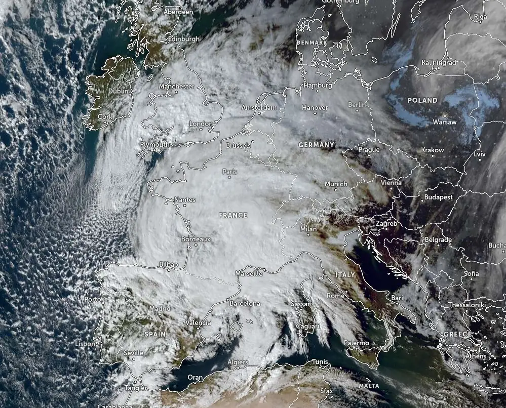
France’s national flood monitoring service Vigicrues reports that soil moisture in the country has reached its highest level since records began in 1959. Authorities described the situation as unprecedented within the operational history of the service.
Vigicrues director Lucie Chadourne-Facon stated that France has experienced 30 consecutive days with continuous orange or red flood alerts somewhere on national territory.
“That is 81 departments in alert simultaneously for 154 rivers, so we have exceeded all our records,” she said.
“We are facing a generalised flood situation across the entire country because all the soils are saturated everywhere and have lost their infiltration capacity.”
Prolonged precipitation left soils fully saturated, significantly reducing infiltration capacity and increasing direct surface runoff into river systems. Under such conditions, even moderate additional rainfall can rapidly translate into river level rises because the soil is unable to absorb further moisture.
Monitoring services warned that additional rainfall forecast during the week may prolong elevated river stages in already affected basins.
River levels peaked over the weekend in Gironde and Lot-et-Garonne following sustained inflows in the Garonne basin. The Garonne River overflowed in several areas of southwestern France, inundating residential neighborhoods and agricultural land. In Lot-et-Garonne, approximately 1 700 people have been evacuated since February 10 due to rising waters.
In Gironde, around 20 residents were evacuated on February 16 as local flooding persisted. In Charente, 66 residents of a care home in La Rochefoucauld were evacuated as a precaution because of the facility’s proximity to a river experiencing elevated discharge.
In Paris, the Seine rose approximately 4 m (13 feet) above its normal level, prompting the closure of riverside motorways and suspension of tourist boat services. Navigation along affected sections of the river was restricted to emergency operations only.
The broader storm system, named Storm Nils, affecting France and Spain between February 11 and 16 resulted in at least three confirmed fatalities. Two deaths occurred in France, including a lorry driver killed near Dax in the Landes department after a tree branch fell onto his vehicle. In addition, in Utelle in the Alpes-Maritimes department, a landslide on February 14 caused one fatality. One fatality was reported in Spain after the roof of an industrial warehouse collapsed
Electricity distribution was also affected during the peak of the latest storm. According to French utility company Enedis, more than 900 000 customers experienced power outages on February 12. As of February 16, over 9 500 households remained without electricity in impacted regions.
In its National Flood Warning Information Bulletin issued at 10:31 LT on February 17, Vigicrues announced that the maximum metropolitan flood alert level is red. The service described the situation as “a significant, prolonged, and widespread flooding event affecting a large part of the country.”
Major flooding is underway along the Garonne River near Marmande and in the Gironde estuary. After two days of gradual recession, water levels on the lower Garonne began rising again on February 17, although forecasts indicate levels are expected to remain below the peaks reached over the weekend.
The combined flooding of the upper Loire, the Vienne, and tributaries of the Maine basin is generating major flooding in the Lower Anjou Valleys and along the Loire near Saumur. Major flooding is expected from Tuesday afternoon, February 17, on the Maine River near Angers and during the night of Tuesday to Wednesday on the Loire at Ponts-de-Cé. Levels are forecast to continue rising through Wednesday.
The bulletin states that further rises in water levels are expected across many river basins as additional rainfall impacts western regions. Another active weather system — Storm Pedro — is forecast to move across the west of the country on Wednesday, following renewed rainfall over Brittany.
On estuary-influenced sections, rising tidal coefficients combined with high upstream discharge are producing flooding during high tide. The Loire estuary is under orange alert, with high tide on Wednesday morning expected to disrupt downstream flow conditions.
Frequent rain and showers are expected to continue along the eastern border, particularly between the Northern Alps and the Vosges Mountains. The rain–snow line is forecast to lower to 700–800 m (2 300–2 600 feet). Avalanche risk remains high in the Alps and Pyrenees, with additional concern for snow slides in parts of the Massif Central.
Météo-France forecasts extremely unsettled conditions nationwide on Wednesday, February 18, and Thursday, February 19, under the influence of Storm Pedro.
On Wednesday, a first frontal system will cross much of the northern half of the country. Interaction with a colder air mass over Benelux and Germany is expected to bring snowfall during the morning from Seine-Maritime through Picardy and Lorraine, extending to the Vosges Mountains. Snow accumulations of a few centimeters are possible, locally up to 5 cm (2 inches) at higher elevations, before partial melting later in the day.
A second band of rainfall caused by Storm Pedro is forecast to bring sustained and locally thundery precipitation. Rainfall totals on February 18 are expected to reach 15–30 mm (0.6–1.2 inches) from Brittany to the Paris Basin, with localized totals of 40–50 mm (1.6–2 inches) at the tip of Brittany, occurring on already saturated ground.
On Thursday, February 19, significant rainfall is forecast for southwestern France, with totals of 30–50 mm (1.2–2 inches), particularly across the western Massif Central and the Alps. Strong winds are expected from Aquitaine to Occitanie, with tramontane gusts reaching up to 120 km/h (75 mph) in Roussillon. Westerly winds are also forecast to strengthen again from the Var coast to Corsica.
Along the Atlantic coast on Thursday morning, the combination of Storm Pedro and high tidal coefficients is expected to generate large waves.
Heavy snowfall is forecast to continue in eastern mountain ranges, especially in the Alps, where fresh snow accumulations are expected to be substantial. Avalanche danger is likely to remain particularly high in mountainous regions.
Pressure is forecast to rise from Friday onward, bringing drier conditions. The unsettled weather band is expected to shift northward across Europe, with improving conditions across southern France toward the end of the week.
Météo-France advises residents in affected areas to avoid flooded roads, move away from waterways, refrain from unnecessary travel, remain informed about rising water levels, avoid basements, and prepare emergency kits where required.
Featured image credit: Meteo-France
I'm a dedicated researcher, journalist, and editor at The Watchers. With over 20 years of experience in the media industry, I specialize in hard science news, focusing on extreme weather, seismic and volcanic activity, space weather, and astronomy, including near-Earth objects and planetary defense strategies. You can reach me at teo /at/ watchers.news.
A telling silence on the conveyance of heat-flux originating from beneath the surface?
Suggesting outer core-instability with links to the magnetic field, as a driver to global humidity?
The data is there, rich, diverse yet coherent.
Imagine small yet hot deep-ocean bottom locations touching our conveyors.
How has the Mediterranean warmed, it’s not conveyor-influenced? Exactly.. the mantle heat-flux… skews the numbers on early-season NH methane, too.
Surely AGW? Contributing but unfortunately heat-flux numbers too great by too many magnitudes, as a quick help also look at economic-activity with the numbers.
Earth’s crustal-rotation speed has changed in time-measurements while core rotation suggested not, 1972 inflexion-point? Tie that with world magnetic map. I suspect we’d also see small gravitational and Schumann-resonance energy-density trends over that time. Oh, we do. What am I missing?
Cycle symptoms? Genetic ‘bottlenecks’. Flood issues indeed. Still, could be worse.
Regards fellow Watchers.