
Series of atmospheric rivers forecast to bring heavy rain to the Pacific Northwest this week
Four atmospheric rivers (ARs) are forecast to impact the Pacific Northwest from Tuesday, January 28 through January 31, 2026, bringing several days of moderate to heavy precipitation, with rainfall totals reaching 125–250 mm (5–10 inches) over the Olympic Peninsula and 50–125 mm (2–5 inches) across the Willapa Hills, northern Oregon Coast Ranges, and Washington Cascades.
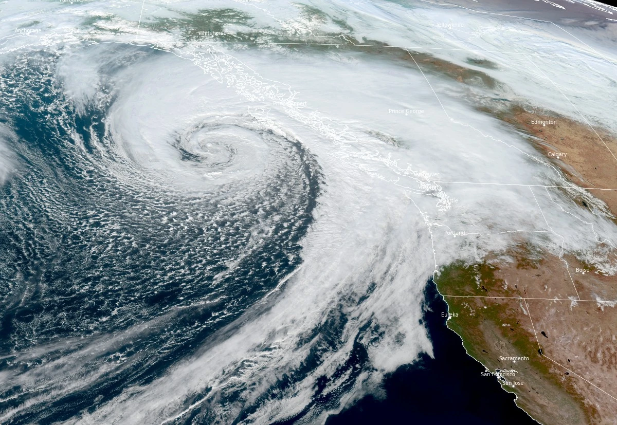
Satellite image of atmospheric river impacting Canada and United States at 21:10 UTC on October 28, 2025. Credit: NOAA/GOES-West, RAMMB/CIRA, The Watchers
A series of atmospheric rivers (AR) is forecast to propagate across the northeast Pacific and make landfall along the U.S. West Coast beginning on January 27, 2026.
The first AR is expected to reach coastal Washington, Oregon, and northern California on Tuesday, bringing light to moderate rainfall. Two stronger ARs are forecast to follow on January 28 and 29, producing widespread moderate to heavy precipitation over western Washington and Oregon.
The CW3E AR Landfall Tool, based on the Global Ensemble Forecast System (GEFS), shows over 90% probability of a brief period of AR conditions with integrated vapor transport (IVT) values of over 250 kg m-1 s-1 between the Olympic Peninsula and northern California on January 27.
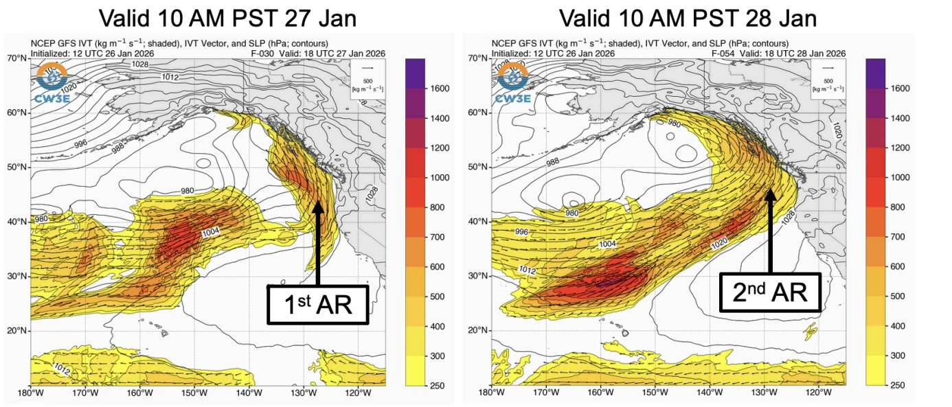
High probabilities of over 80% persist for AR conditions from January 28 through early January 30 in association with the second and third ARs.
AR 2 to AR 3 conditions are forecast for coastal Washington and northern coastal Oregon during the second and third ARs. About 40–50% of ensemble members predict AR 3 strength in these regions, though model uncertainty remains regarding timing and duration.
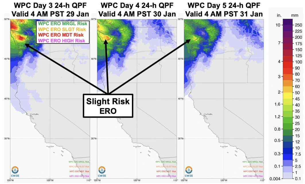
Precipitation totals are forecast to reach 125–250 mm (5–10 inches) over the Olympic Peninsula during the next seven days, according to the Weather Prediction Center (WPC).
Totals of 50–125 mm (2–5 inches) are forecast for the Willapa Hills, northern Oregon Coast Ranges, and Washington Cascades. The WPC has issued marginal risk (level 1 of 4) excessive rainfall outlooks over the Olympic Peninsula through January 31, with a slight risk for portions of western Washington later in the period.
Freezing levels across the Washington Cascades are expected to remain elevated, above 1 500 m (5 000 feet), throughout the sequence, limiting snow accumulation potential.
References:
1 Quick Look at the Atmospheric Rivers Forecast to Impact the Pacific Northwest – CW3E – January 26, 2026

I am an Assistant Editor and Severe Weather & Science Journalist at The Watchers, specializing in real-time severe weather coverage, geophysical event reporting, and research-driven scientific analysis. You can reach me at rishav(at)watchers(.)news.
Commenting rules and guidelines
We value the thoughts and opinions of our readers and welcome healthy discussions on our website. In order to maintain a respectful and positive community, we ask that all commenters follow these rules.