
Winter storm watches in effect across central and southern United States
Winter storm watches are in effect from New Mexico and Texas to Arkansas, Tennessee, and Kentucky, from Friday morning through late Saturday night, January 23–24, 2026, with some extending into Sunday afternoon, January 25. Heavy snow, sleet, and ice accumulations are forecast, along with dangerously cold temperatures that will persist into Monday morning, January 26.
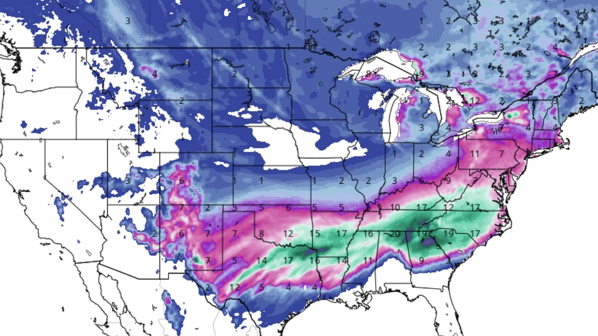
GFS Total Snowfall for the period January 21-28, 2026. Credit: Tropical Tidbits
Winter storm watches have been issued across the central and southern United States due to a major winter storm forecast to move into the region starting January 23.
The watches were issued during the early hours of January 21 by multiple National Weather Service (NWS) forecast offices covering New Mexico, Texas, Oklahoma, Kansas, Arkansas, Louisiana, Missouri, Alabama, and Tennessee.
In New Mexico, a Winter Storm Watch is in effect from January 23 to 25 for much of central and eastern New Mexico, including Santa Fe, Clovis, Roswell, and the South Central Mountains.
Snow accumulations of 13–25 cm (5–10 inches) are forecast across most areas, with up to 40 cm (16 inches) above 2 700 m (9 000 feet). Temperatures across the eastern plains are forecast to drop into the single digits by Sunday morning. Travel along I-40 and I-25 may become very difficult or impossible.
In Texas, several NWS offices issued winter storm watches for large portions of the state. The NWS El Paso/Santa Teresa office issued a Winter Storm Watch from Friday morning through late Saturday night for the Sacramento Mountains, where snow accumulations of 13–25 cm (5–10 inches) are possible.
The NWS Midland/Odessa and NWS San Angelo offices issued winter storm watches from Friday afternoon through late Saturday night for the Permian Basin, Upper Trans-Pecos, and West Central Texas.
Heavy snow, sleet, and ice are forecast, with very cold temperatures forecast from Saturday night through Monday morning. The NWS Fort Worth office issued a Winter Storm Watch from Friday afternoon through late Saturday night for North and Central Texas, including the Dallas–Fort Worth Metroplex, Waco, and Killeen.
In Oklahoma and northern Texas, the NWS Norman and NWS Tulsa offices issued winter storm watches from Friday afternoon through early Sunday morning, January 23–25. Heavy mixed precipitation may produce over 15 cm (6 inches) of snow in northern areas and up to 5 mm (0.2 inches) of ice in southern Oklahoma. Wind gusts may reach 56 km/h (35 mph), with wind chill values forecast to fall below −18°C (0 °F).
Winter storm watches are in effect for southern and central counties in Kansas from Friday morning through late Saturday night, with snow accumulations of 8–18 cm (3–7 inches) forecast and locally higher amounts near the Kansas–Oklahoma border.
A winter storm watch is in effect from Friday afternoon through late Saturday night. Snow accumulations of 10–20 cm (4–8 inches) are forecast across central and northern areas, with localized totals of up to 25 cm (10 inches). Ice accumulations of 6–13 mm (0.25–0.5 inches) are possible in southern counties.
The NWS Shreveport office issued winter storm watches from Friday morning through Sunday morning for southern Arkansas, northern Louisiana, southeast Oklahoma, and northeast Texas. Up to 20 cm (8 inches) of combined snow and sleet is forecast, along with ice accretion.
Winter storm watches are in effect across southern Missouri from Friday afternoon through late Saturday night, with snow accumulations of 8–18 cm (3–7 inches) being forecast.
In Alabama and Tennessee, the NWS offices in Birmingham, Huntsville, Nashville, and Memphis issued winter storm watches from Friday evening through Sunday afternoon. Combined snow and ice accumulations may exceed 15 cm (6 inches), with more than 6 mm (0.25 inches) of ice possible.
The winter storm will be followed by Arctic air through the weekend. Below-freezing temperatures are forecast across nearly the entire watch area, with many locations falling into single digits. Wind chills below −18°C (0°F) are forecast for parts of Texas, Oklahoma, and Kansas.
The NWS advised residents in all watch areas to complete preparations before Friday. Additional warnings and advisories may be issued as forecast confidence increases.
References:
1 Winter Storm Watch – NWS – January 21, 2025

I am an Assistant Editor and Severe Weather & Science Journalist at The Watchers, specializing in real-time severe weather coverage, geophysical event reporting, and research-driven scientific analysis. You can reach me at rishav(at)watchers(.)news.
Commenting rules and guidelines
We value the thoughts and opinions of our readers and welcome healthy discussions on our website. In order to maintain a respectful and positive community, we ask that all commenters follow these rules.