
Flood Watch and marine Storm and Gale Warnings in effect for Mendocino and Lake counties region, California
Interior Mendocino and Lake counties are under a Flood Watch from late Wednesday, November 12, through Thursday morning, November 13, 2025, as 50–75 mm (2–3 inches) of rain is forecast within several hours. Marine Storm and Gale Warnings are also in effect offshore, where winds up to 95 km/h (60 mph) and seas up to 8 m (27 feet) are expected.
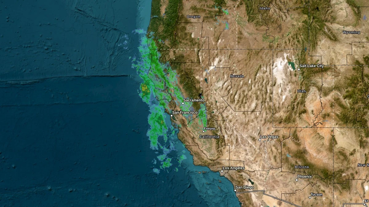
Image credit: NWS. Acquired at 10:28 UTC on November 13, 2025
A Flood Watch is in effect for interior Mendocino and Lake counties, California, from late November 12 through Thursday morning, November 13, as a quick-moving cold front embedded in a strong atmospheric river is forecast to bring moderate to heavy rainfall to the region in a short period.
According to the National Weather Service (NWS), flooding caused by excessive rainfall is possible, with the greatest risk focused on urban areas around Ukiah and Clear Lake and the heaviest rain rates expected around Cobb in southern Lake County.
The NWS forecasts total rainfall of 50–75 mm (2–3 inches) across Mendocino and Lake counties during the event, with most of the precipitation expected to fall over roughly 6 hours early Thursday morning. This temporal concentration increases the likelihood of minor to moderate roadway and urban flooding, particularly in locations with poor drainage or where intense rain rates briefly exceed local infiltration capacity.
In addition to urban and street flooding, there is also an increased risk of rock and landslides along area roadways. Steep, forested terrain in both counties and cut slopes along highways are susceptible to shallow slope failures when soils are rapidly saturated.
The NWS warns that rock and landslides along roadways will become more likely during the period of heaviest rainfall and advises motorists to take extra caution if driving.
The atmospheric river responsible for this event developed offshore in association with a deep upper-level trough and an area of enhanced subtropical moisture. The Center for Western Weather and Water Extremes (CW3E) describes the system as a strong atmospheric river with integrated vapor transport (IVT) exceeding 750 kg m-1 s-1 over northern California.
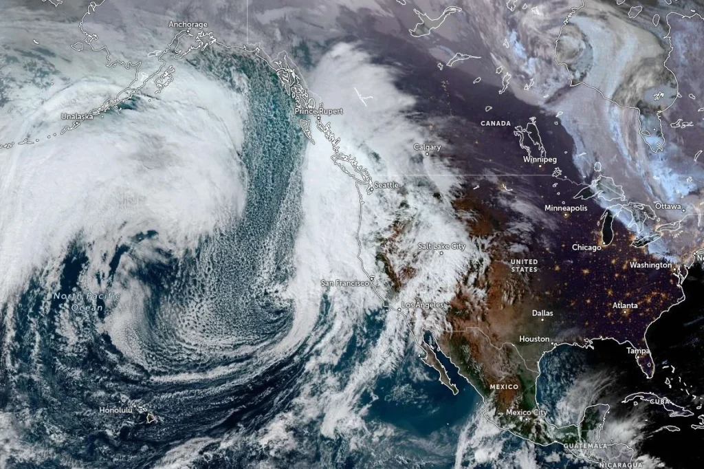
Ensemble forecasts from the Global Ensemble Forecast System (GEFS) and ECMWF indicate AR 5/AR 3 conditions along the coast of northern and central California, though there remains uncertainty in the duration and intensity of atmospheric river conditions due to the evolution of a cutoff low over the region.
The NWS Weather Prediction Center (WPC) is forecasting a broad swath of 50–100 mm (2–4 inches) of precipitation over much of California, with locally more than 100 mm (>4 inches) in the coastal ranges of northern and central California, along the Sierra Nevada, and in the Transverse Ranges.
Model precipitation totals from the GFS and ECMWF suggest that this event could deliver more than 5–10% of the annual rainfall in multiple catchments. Freezing levels are forecast to remain relatively high during the event, limiting significant snowfall to the highest elevations of the Sierra Nevada and keeping most of the precipitation in Mendocino and Lake counties in the form of rain.
The NWS Hanford office has a separate Flood Watch in effect from Thursday morning through Friday afternoon, November 14, for portions of the Mariposa–Madera foothills, lower Sierra slopes, Yosemite Valley and the San Joaquin River Canyon, and from late Thursday night through Saturday evening, November 15 for the south end of the Sierra foothills, south end of the lower Sierra and Kern River Valley.
In those areas, heavy rain may cause flooding of rivers, creeks, streams, and other low-lying, flood-prone areas.
Over the coastal waters adjacent to northern and central California, multiple storm and gale warnings are in effect. For the offshore zones from Point St. George to Cape Mendocino and from Cape Mendocino to Point Arena, storm warnings call for southeast winds of 55–75 km/h (35–45 mph) with gusts up to about 95 km/h (60 mph) and combined seas of 3.5–4 m (11–13 feet).
As the system progresses, gale warnings replace storm warnings, with south winds of about 45–65 km/h (30–40 mph) and gusts up to roughly 85 km/h (50 mph) and seas building to 4–5 m (13–17 feet).
Mariners are advised that very strong winds will create hazardous seas capable of capsizing or damaging vessels and reducing visibility, and are urged to remain in port, alter course, and secure vessels for severe conditions.
Farther south, the NWS San Francisco Bay Area office has issued storm warnings for coastal waters from Point Arena to Point Reyes and from Point Reyes to Pigeon Point out to about 20 km (12 miles) offshore, as well as for waters from Point Arena to Point Reyes and from Point Reyes to Pigeon Point roughly 20–110 km (15–70 miles) offshore.
Forecasts for these zones indicate southeast or south winds of about 35–65 km/h (20–40 mph), with gusts up to approximately 100 km/h (60 mph), and seas of 2.5–4.5 m (8–15 feet) through Thursday morning.
Offshore waters forecasts from the Ocean Prediction Center extend the marine hazard envelope farther west into the outer waters about 110–460 km (70–290 miles) offshore Washington, Oregon, and California.
Storm warnings for zones from Cape Lookout to Florence, Oregon, and from Florence, Oregon, to Point St. George between roughly 280 and 460 km (170–290 miles) offshore, call for north or northwest winds of about 75–95 km/h (45–60 mph) and seas up to 8 m (27 feet).
For the outer California waters between Point St. George and Point Arena and between Point Arena and Pigeon Point roughly 110–460 km (70–290 miles) offshore, storm warnings indicate south to southwest winds up to about 75–95 km/h (45–60 mph) with seas of 4–8 m (13–27 feet), followed by strong northwest winds and large residual swell as the system moves east.
References:
1 AR update – CW3E – November 12, 2025
I'm a dedicated researcher, journalist, and editor at The Watchers. With over 20 years of experience in the media industry, I specialize in hard science news, focusing on extreme weather, seismic and volcanic activity, space weather, and astronomy, including near-Earth objects and planetary defense strategies. You can reach me at teo /at/ watchers.news.
Commenting rules and guidelines
We value the thoughts and opinions of our readers and welcome healthy discussions on our website. In order to maintain a respectful and positive community, we ask that all commenters follow these rules.