
First of multiple atmospheric rivers to bring AR4 conditions and rising streamflows to western Washington
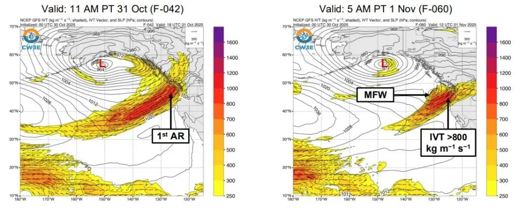
A strong atmospheric river is forecast to make landfall over the Pacific Northwest early on October 31, 2025, bringing heavy rainfall and high freezing levels to western Washington. The event is expected to produce AR3–AR4 conditions, with 75–125 mm (3–5 inches) of rain forecast in the Olympic Peninsula and North Cascades. Two additional atmospheric rivers are expected to follow between November 3 and 5.

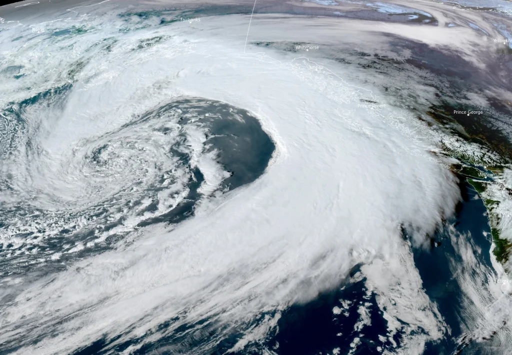
Image acquired at 23:20 UTC on October 30, 2025. Credit: NOAA/GOES-East, Zoom Earth, The Watchers
A strong atmospheric river associated with a large area of low pressure in the Gulf of Alaska is forecast to make landfall over the Pacific Northwest early on Friday, October 31.
The Center for Western Weather and Water Extremes (CW3E) forecasts the event will bring intense integrated vapor transport and widespread precipitation to western Washington and northwestern Oregon.
The first atmospheric river is expected to produce AR3–AR4 conditions on the Ralph et al. (2019) AR Scale, which classifies events from AR1 (weak) to AR5 (exceptional, most hazardous). CW3E forecasts integrated vapor transport magnitudes approaching 1 000 kg m⁻¹ s⁻¹ in coastal areas during the strongest pulse, driven by a mesoscale frontal wave forming along the primary moisture plume.
The National Weather Service (NWS) Weather Prediction Center (WPC) forecasts 75–125 mm (3–5 inches) of total rainfall in the Olympic Peninsula and North Cascades, with 25–75 mm (1–3 inches) expected elsewhere across western Washington and northwestern Oregon.
High freezing levels, starting near 3 000 m (10 000 feet) and remaining above 1 800 m (6 000 feet) through the event, are expected to enhance runoff and increase river discharge.
CW3E hydrologic outlooks indicate that seven stream gages in western Washington are forecast to exceed the monitor or action stage between November 1 and 2, including the Snoqualmie River near Carnation. The WPC has issued a marginal risk (level 1 of 4) excessive rainfall outlook for much of western Washington during the 24-hour period ending 05:00 PT on November 1.
After the first system weakens and moves inland, a secondary moisture plume is expected to form offshore, marking the onset of the next atmospheric river early next week.
Following the passage of the first system, a second, weaker atmospheric river is forecast to develop off the U.S. West Coast and make landfall over Oregon and far northern California on Monday, November 3.
This second event is expected to produce 25–75 mm (1–3 inches) of rain across western Oregon and northern California, with localized higher totals of up to 125 mm (5 inches) possible in orographically enhanced terrain such as the Klamath Mountains.
A third atmospheric river, associated with a large closed low over the northeast Pacific, is forecast to approach the coast on Tuesday, November 4, but forecast models differ on the timing and intensity of this system.
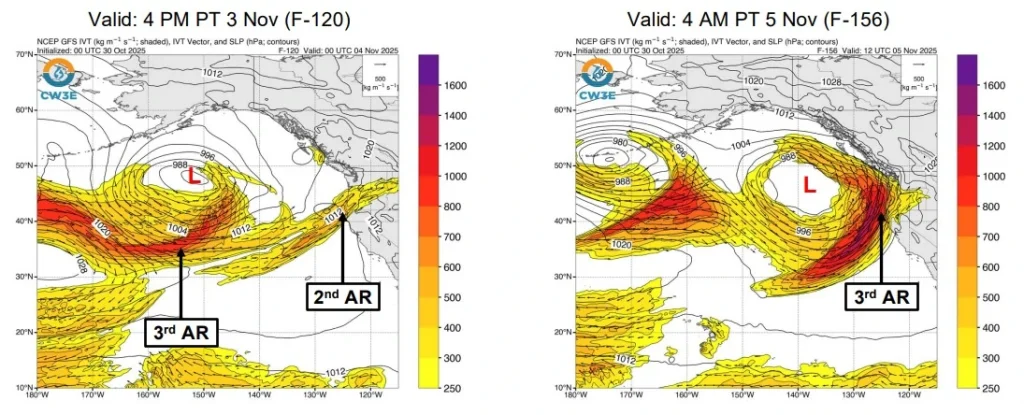
The European Centre for Medium-Range Weather Forecasts (ECMWF) ensemble favors an earlier and stronger landfall, while the NOAA Global Ensemble Forecast System (GEFS) suggests a later and weaker arrival. About 70% of ECMWF ensemble members indicate AR4 or greater conditions in southern coastal Oregon, compared to only 35% of GEFS members.
ECMWF also shows a 45% probability of AR5 conditions during the third event, with some members maintaining continuous atmospheric river conditions through November 6–7, suggesting a possible fourth system late in the period.
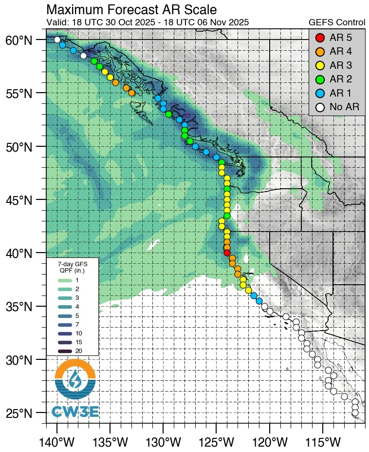
Across the 10-day outlook, deterministic and ensemble forecasts show significant differences in precipitation totals. In the Wilson–Trusk–Nestuccu watershed of northwestern Oregon, ECMWF predicts approximately 186 mm (7.3 inches) of precipitation, while GFS forecasts 79 mm (3.1 inches).
The ECMWF ensemble consistently produces wetter solutions across western Washington and Oregon than the GEFS ensemble.
Forecast confidence remains highest for the first atmospheric river, with increasing uncertainty for subsequent events due to the dynamic evolution of the large-scale Pacific low.
I'm a dedicated researcher, journalist, and editor at The Watchers. With over 20 years of experience in the media industry, I specialize in hard science news, focusing on extreme weather, seismic and volcanic activity, space weather, and astronomy, including near-Earth objects and planetary defense strategies. You can reach me at teo /at/ watchers.news.
Commenting rules and guidelines
We value the thoughts and opinions of our readers and welcome healthy discussions on our website. In order to maintain a respectful and positive community, we ask that all commenters follow these rules.