
Eye of Super Typhoon Ragasa moves over Calayan Island, Cagayan, Philippines
Super Typhoon Ragasa, locally named Nando, began crossing Calayan Island in Cagayan province, northern Philippines, at around 03:00 UTC (11:00 LT) on September 22, 2025, bringing destructive winds, extreme seas, and life-threatening storm surge. The Philippine weather bureau reported maximum 10-minute sustained winds of 215 km/h (134 mph) and gusts up to 295 km/h (183 mph).

Satellite image of Super Typhoon Ragasa over Calayan, Philippines at 06:40 UTC on September 22, 2025. Credit: JMA/Himawari-9, RAMMB/CIRA, The Watchers
Super Typhoon Ragasa, locally named Nando, passed directly over Calayan Island in Cagayan province, northern Philippines, on September 22.
Satellite and ground observations confirm the eye of the storm reached the island around 03:00 UTC (11:00 LT) and remained overhead over the next couple of hours.
At 03:00 UTC, the Joint Typhoon Warning Center (JTWC) reported Ragasa was a super typhoon with maximum 1-minute sustained winds of 270 km/h (165 mph), moving west at 22 km/h (14 mph). The agency said that an earlier eyewall replacement cycle had ended, and Ragasa maintained a symmetric 74 km (46 miles) wide eye with strong radial outflow and highly favorable conditions for sustaining extreme intensity.

Authorities in the northern Philippines carried out large-scale evacuations ahead of Ragasa’s passage. In Cagayan province, more than 8 200 people were moved to safer areas, while in Apayao province, over 1 200 residents sought shelter in evacuation centers.
Power outages were reported across Calayan Island and in the upland province of Apayao as Ragasa’s destructive winds brought down transmission lines.
Domestic flights were cancelled while ferry and fishing boat operations were suspended due to extremely rough seas.
Classes and government work were suspended in 29 northern provinces, including in the capital Manila, as precautionary measures.

At 06:00 UTC (14:00 LT), the Philippine Atmospheric, Geophysical and Astronomical Services Administration (PAGASA) said the center of Ragasa over the coastal waters of Babuyan and Calayan. PAGASA estimated maximum 10-minute sustained winds at 215 km/h (134 mph) near the center and gusts up to 295 km/h (183 mph), moving westward at 25 km/h (16 mph).
The agency warned of life-threatening conditions across northern Luzon, including storm surges exceeding 3 m (10 feet) in low-lying coastal areas of Batanes, Cagayan including Babuyan Islands, Ilocos Norte, and Ilocos Sur.
Sea conditions are extremely dangerous, with significant wave heights forecast up to 14 m (46 feet) around Batanes and Babuyan, 12 m (39 feet) along northern Ilocos Norte, and 10 m (33 feet) along northern mainland Cagayan.


PAGASA placed the Babuyan Islands under Tropical Cyclone Wind Signal No. 5 at 14:00 LT. In this zone, extreme impacts are anticipated, with near-total destruction of light structures likely and severe damage expected across exposed communities.
Signal No. 4 was raised over southern Batanes, northern mainland Cagayan, and northern Ilocos Norte. The areas are under threat from very strong, destructive winds that may cause widespread damage to buildings, agriculture, and infrastructure.
Signals No. 3 to No. 1 were raised over the rest of Cagayan, Batanes, Apayao, Ilocos Norte and Sur, Isabela, the Cordillera provinces, and parts of Central Luzon. Damaging winds of varying intensity are expected there, accompanied by hazardous sea conditions that pose risks to maritime and coastal activities.
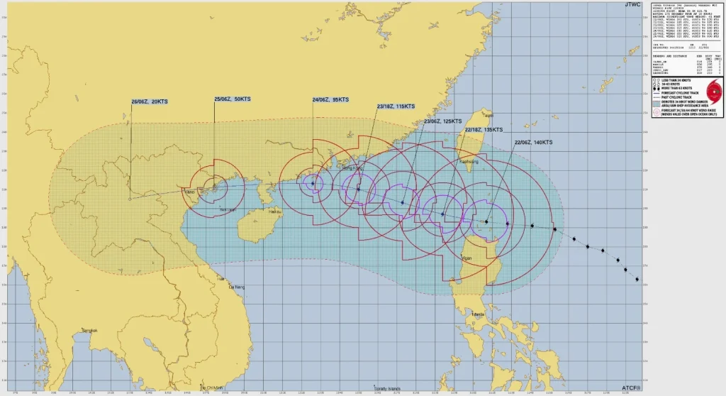
On the forecast track, Ragasa will continue westward across the Luzon Strait and exit the Philippine Area of Responsibility (PAR) on the morning of September 23.
JTWC forecasts maintain super typhoon intensity for at least 24 hours as the system moves into the South China Sea, with weakening expected later due to cooler waters and land interaction along the southern Chinese coast.
Ragasa is projected to pass north of Hainan and make final landfall in northern Vietnam around September 25.
I'm a dedicated researcher, journalist, and editor at The Watchers. With over 20 years of experience in the media industry, I specialize in hard science news, focusing on extreme weather, seismic and volcanic activity, space weather, and astronomy, including near-Earth objects and planetary defense strategies. You can reach me at teo /at/ watchers.news.
Commenting rules and guidelines
We value the thoughts and opinions of our readers and welcome healthy discussions on our website. In order to maintain a respectful and positive community, we ask that all commenters follow these rules.