
Extreme cold warnings issued for Minnesota
Extreme cold warnings and cold weather advisories have been issued for Minnesota from 01:00 to 11:00 local time (LT) on Monday, February 17, 2025, with wind chills expected to drop as low as -43 °C (-45 °F).

Minimum temperature forecast for Minnesota and surrounding regions until Monday evening, February 17, 2025. Image credit: NWS/WPC
Extreme cold warnings and cold weather advisories have been issued for Minnesota from 01:00 to 11:00 local time (LT) on Monday, with wind chills expected to drop as low as -43 °C (-45 °F) in the warning area.
The warnings follow a polar vortex moving southward for the 10th time this season, potentially bringing record-breaking cold temperatures across the United States in the coming week.
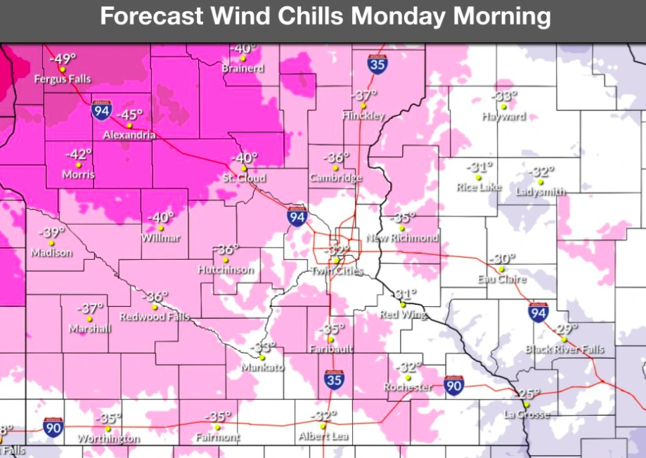
Areas under the warning are expected to experience wind chills between -37 and -43 °C (-35 and -45 °F) on Monday morning, including Hutchinson, Willmar, Madison, Redwood Falls, and Cambridge. Meanwhile, areas under advisory could see wind chills ranging from -32 to -37 °C (-25 to -35 °F).

Temperatures across the affected regions could range from -29 to -23 °C (-20 to -10 °F), with sustained winds of 8 – 16 km/h (5 – 10 mph) and gusts reaching 24 km/h (15 mph).
According to the National Weather Service (NWS), Monday night could be the coldest of the season as a 1 045 hPa high-pressure system strengthens to 1 052 hPa by Tuesday, February 18, settling over the Dakotas.
This system will bring light winds and conditions favorable for significant cooling. Forecasted low temperatures could drop significantly, with some areas in central Minnesota potentially reaching -34 °C (-30 °F) and most of the region falling into the range of -29 to -23 °C (-20 to -10 °F).
Wind chill factors will make temperatures feel even colder, potentially ranging from -37 to -43 °C (-35 to -45 °F), prompting the issuance of an Extreme Cold Watch for late Monday night into Tuesday morning.
The high-pressure system will weaken as it moves into the central Plains, allowing warmer weather to return by Thursday. Temperatures could rise into the range of 1 to 4 °C (30 °F to 40 °F) next weekend and continue warming into the following week.
References:
1 Area forecast discussion – NWS – February 16, 2025

I am an Assistant Editor and Severe Weather & Science Journalist at The Watchers, specializing in real-time severe weather coverage, geophysical event reporting, and research-driven scientific analysis. You can reach me at rishav(at)watchers(.)news.
Commenting rules and guidelines
We value the thoughts and opinions of our readers and welcome healthy discussions on our website. In order to maintain a respectful and positive community, we ask that all commenters follow these rules.