
Coast-to-coast winter storm to bring snow, ice, and severe thunderstorms
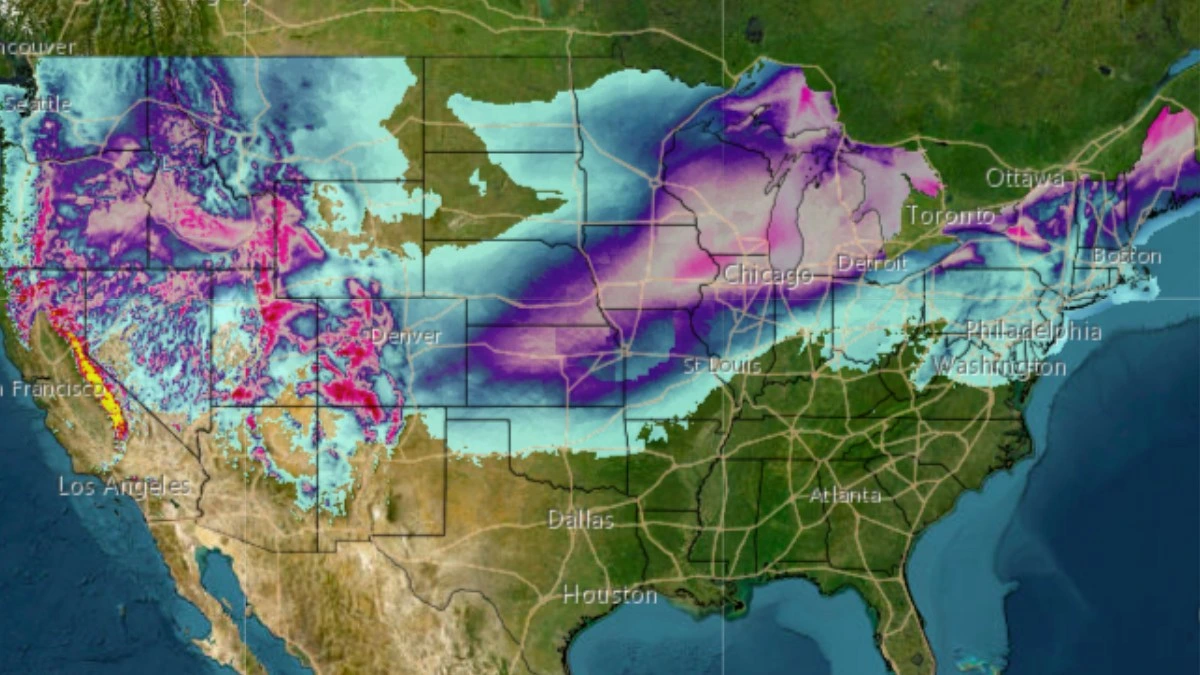
A coast-to-coast winter storm is set to move across the United States beginning Friday, February 14, 2025, bringing heavy snow, ice, and severe weather from the Rockies to the Northeast. The system is expected to intensify as it moves east, impacting millions with snowfall, icy conditions, and potential flash flooding.
Snowfall forecast for coast-to-coast winter storm until Saturday, February 15, 2025. Image credit: NWS/WPC
- A major winter storm will move across the eastern U.S. from Friday, February 14, 2025, bringing heavy snow, ice, and severe weather from the Rockies to the Northeast.
- Significant snowfall is forecast for Utah, Idaho, western Wyoming, and Colorado, with 15 – 25 cm (6 – 10 inches) expected in parts of the Upper Midwest, Great Lakes, and New England.
- A wintry mix, including freezing rain and sleet, is expected from the central Appalachians into the Mid-Atlantic and Northeast, with significant icing possible as far south as the central Appalachians.
“A hyperactive weather pattern will bring an expansive low pressure system across mainland U.S., resulting in widespread impactful weather to progress from west to east across the country through the next few days,” the National Weather Service (NWS) forecaster Kong noted on February 14.
The widespread heavy rain currently in progress across the lower elevations of California, and mountain snows that have already overspread much of the Intermountain West, are the harbingers of things to come for the rest of the country.
The expansive Pacific cyclone responsible for the widespread inclement weather moving into the western U.S. will continue to march eastward through the next few days.
The heavy rain and mountain snow impacting California this morning is expected to gradually taper off later today into this evening when the center of the low pressure system departs and redevelops over the High Plains.
Snowfall associated with the system will expand eastward from the Intermountain West into the Rockies throughout the day.
Heavy snowfall is forecast for Utah, Idaho, western Wyoming, and the mountains of Colorado. Snow is also expected to begin in parts of the Upper Midwest and the Great Lakes late Friday and continue through the weekend.
A wintry mix is anticipated from the central Appalachians into parts of the Mid-Atlantic and the Northeast, with heavy snowfall possible in upstate New York and northern New England. The National Weather Service (NWS) warns of significant icing as far south as the central Appalachians.
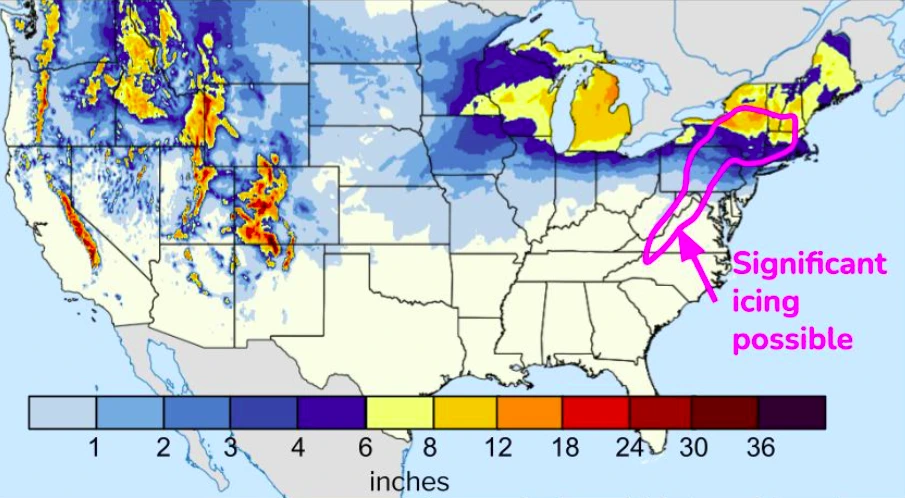
As the storm intensifies while crossing the Ohio Valley from Saturday night into Sunday morning, February 16, snowfall accumulations of 15 – 25 cm (6 – 10 inches) are expected in the Upper Midwest, spreading toward the Great Lakes and New England.
Areas just south of the snow zone, including the central Appalachians, may experience ice and sleet. As the storm intensifies, its associated cold front could produce severe thunderstorms in the Deep South, with potential for large hail, strong winds, and tornadoes in parts of eastern Texas and western Alabama.
Heavy rainfall is expected on Saturday, February 15, which could lead to flash flooding in the Tennessee and Ohio Valleys, as well as moderate to isolated river flooding. The region faces a Moderate Risk for excessive rainfall, with totals forecasted between 75 – 150 mm (3 – 6 inches), with locally higher amounts possible.

References:
1 Short Range Forecast Discussion – NWS/WPC – February 14, 2025

I am an Assistant Editor and Severe Weather & Science Journalist at The Watchers, specializing in real-time severe weather coverage, geophysical event reporting, and research-driven scientific analysis. You can reach me at rishav(at)watchers(.)news.
Commenting rules and guidelines
We value the thoughts and opinions of our readers and welcome healthy discussions on our website. In order to maintain a respectful and positive community, we ask that all commenters follow these rules.