
Coast-to-coast winter storm to impact U.S. from West Coast to Northeast
A coast-to-coast winter storm will move across the United States from February 7 to 9, 2025, bringing heavy snowfall, freezing rain, and hazardous travel conditions from the Pacific Northwest to the Northeast.

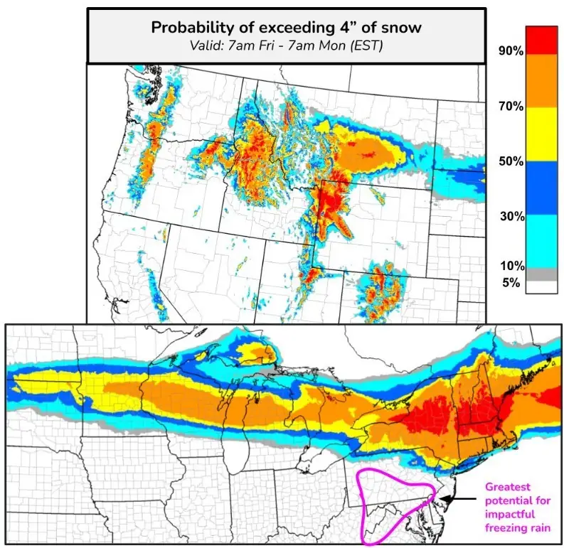
Coast-to-coast winter storm snow forecast map. Image credit: NWS/WPC
- A cross-country winter storm will impact large portions of the United States from February 7 to 9, moving from the Pacific Northwest to the Northeast.
- Some areas could receive more than 20 cm (8 inches) of snow, particularly in the Northern Rockies, Upper Mississippi Valley, Great Lakes, and Northeast.
- Freezing rain may develop along the storm’s southern boundary, with up to 2.5 mm (0.10 inches) of ice accumulation expected in the northern Mid-Atlantic.
Another winter storm is expected to affect a large portion of the United States from February 7 to 9. The system will move from the Pacific Northwest and Northern Intermountain Region eastward toward the Mid-Atlantic and Northeast Coast by February 9, with some areas receiving more than 20 cm (8 inches) of snow.
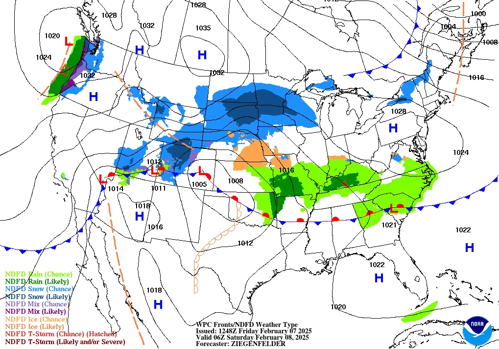
Moderate to heavy snowfall is forecast for the Northern Intermountain Region and Northern Rockies on February 7. Light rain and snow at higher elevations will develop in parts of California. By the afternoon, snowfall will intensify and spread from the Northern Rockies into the Northern Plains and Upper Mississippi Valley.
Light rain will develop in the eastern portion of the storm system on February 7, affecting areas from the Lower Mississippi Valley to the Mid-Atlantic. Mountain passes and higher elevations will experience hazardous travel conditions.

The storm will move through the Midwest, bringing heavy snowfall from the Dakotas to the Great Lakes on February 8.
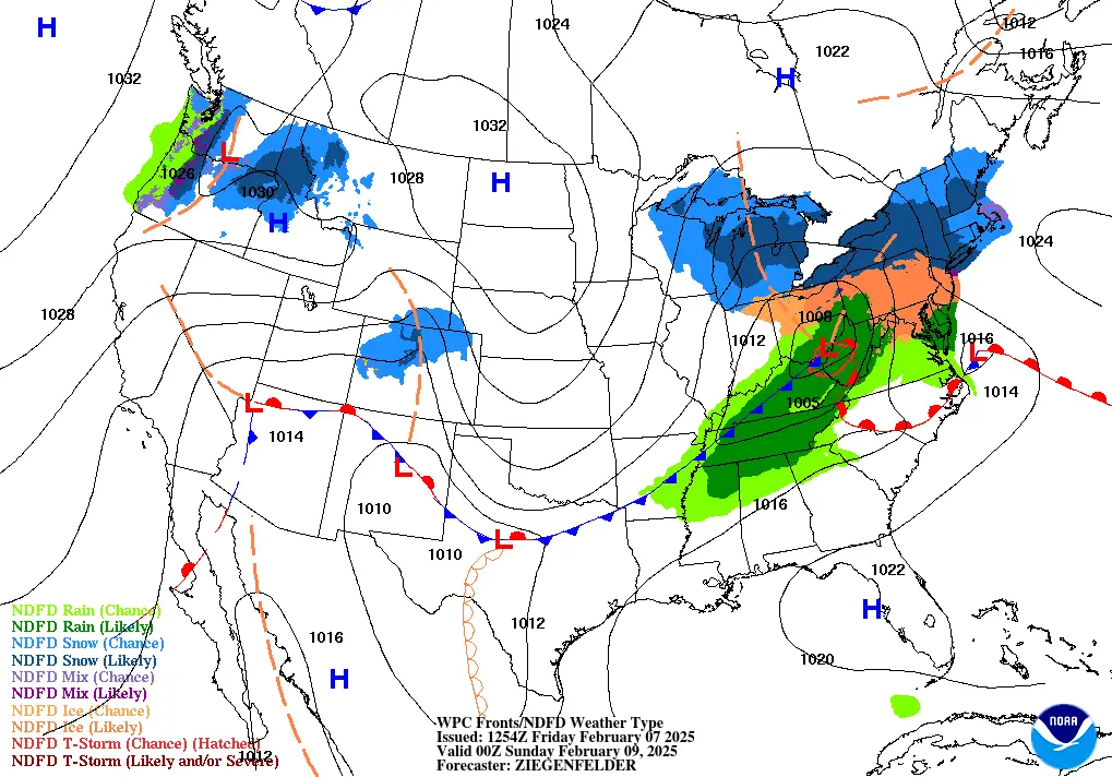
Moderate to heavy snowfall will move from the Upper Mississippi Valley into the Great Lakes and then into the Lower Great Lakes by the evening of February 8. Snowfall will also affect parts of the Northeast overnight into February 9.
Light rain and freezing rain may develop along the rain/snow boundary in the Central Appalachians early on February 8, while rain will persist from the Ohio and Tennessee Valleys into the Mid-Atlantic.
Light rain and freezing rain could also impact parts of the Ohio Valley and the Mid-Atlantic, with up to 2.5 mm (0.10 inches) of ice accumulation expected in the northern Mid-Atlantic.
Upper-level energy will bring coastal rain and higher-elevation snowfall to the Pacific Northwest, with snow spreading inland to the Northern Intermountain Region overnight on February 8. A separate low-pressure system over the Central and Southern Rockies will generate light snowfall in parts of the Central Rockies.
Winter Storm Warnings and Watches have been issued across the affected areas. Hazardous winter weather will create dangerous travel conditions, and residents are advised to monitor local forecasts and avoid travel unless necessary.
A cold front trailing the system will lower temperatures by 3 to 5 °C (5 to 10 °F) below normal. South of the front, areas including southeastern New Mexico, Texas, the Lower Mississippi Valley, Tennessee Valley, and Deep South will experience temperatures 10 to 17 °C (20 to 30 °F) above normal, with some record highs possible on February 7 and especially February 8.
As the cold front advances through the Ohio and Tennessee Valleys into February 9, record warmth will shift toward the East Coast and the Carolinas.
In the desert Southwest, increased winds and low relative humidity as the storm develops could lead to critical fire weather conditions, particularly in the Upper Rio Grande Valley of New Mexico and the High Plains. Red Flag Warnings have been issued for some locations.
References:
1 Short Range Forecast Discussion – NWS – February 7, 2025

I am an Assistant Editor and Severe Weather & Science Journalist at The Watchers, specializing in real-time severe weather coverage, geophysical event reporting, and research-driven scientific analysis. You can reach me at rishav(at)watchers(.)news.
FYI — N.Y. Gov. Hochul declares state of emergency amid weekend winter storms —
– SILive (Staten Island, NY) – Published: Feb. 07, 2025, 8:02 p.m. –
.
– EXCERPT – STATEN ISLAND, N.Y. — New York Gov. Kathy Hochul declared a state of emergency on Friday in an effort to improve resource coordination with local governments amid two weekend winter storms.
– The first storm began earlier on Friday and has brought snow with anticipated peak accumulations of up to 10 inches to parts of central New York and the Mohawk Valley. This precipitation is expected to continue into Friday evening and be blown about by wind gusts of up to 45 mph.
– As of Friday evening, snow and sleet accumulations in the five boroughs are expected to measure between 3 and 5 inches. Meanwhile, the area from central New York to the Capital Region could see upwards of 7 inches of snow. A widespread blanket of 3 to 6 inches of accumulation is anticipated to fall north of the New York State Thruway. … –
.