
Major tectonic tear found beneath Iraq, Turkey, and Iran
An international research team led by the University of Göttingen has discovered that the Neotethys oceanic plate is breaking off horizontally. This geological phenomenon is occurring deep beneath the Earth’s surface, with a tear extending from southeast Turkey to northwest Iran. The study focused on the impact of the Zagros Mountains’ forces in the Kurdistan region of Iraq, revealing significant bending of the Earth’s surface over the past 20 million years.

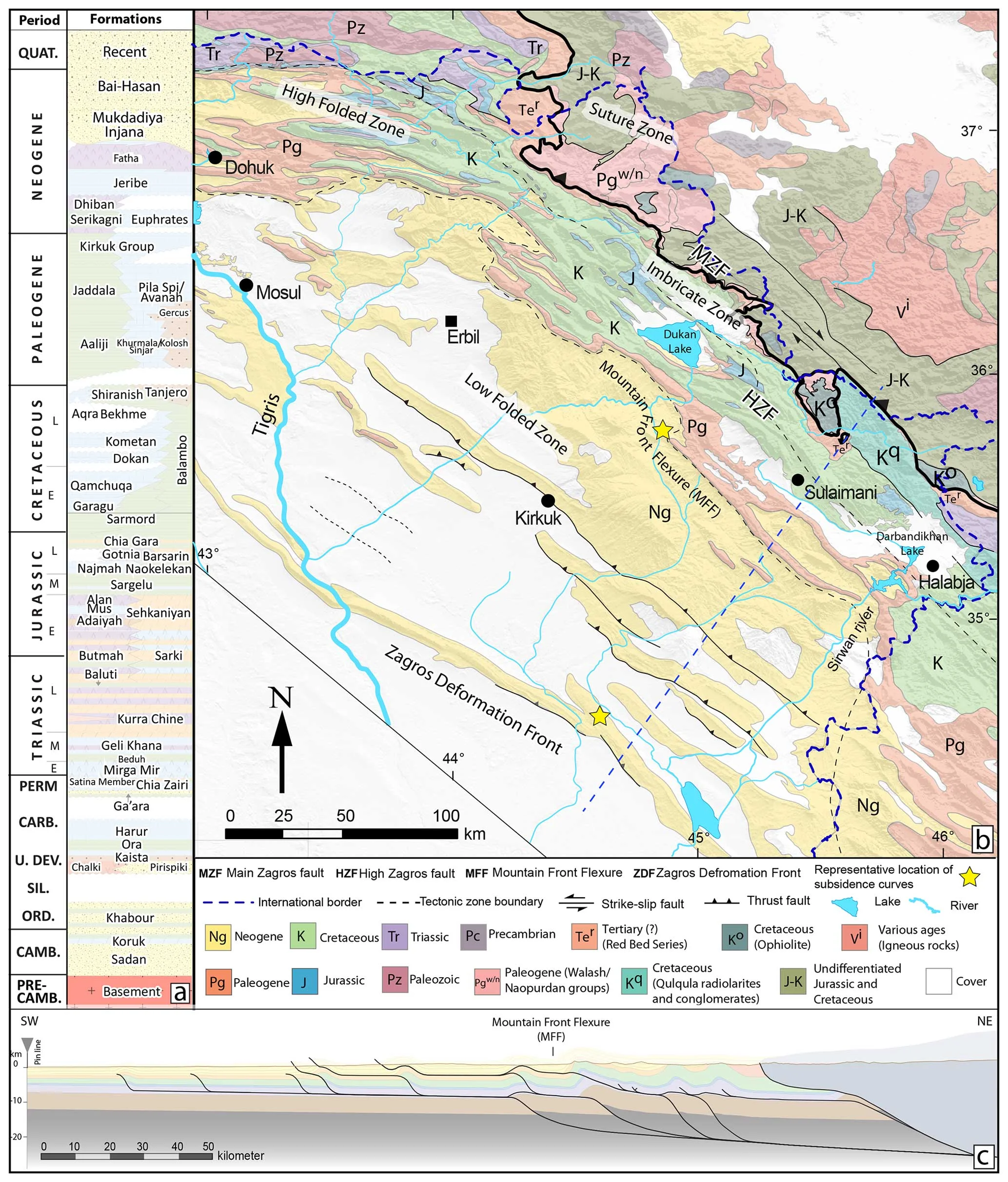
Tectonic map of the Middle East showing the main structural features, tectonic plates, and the study area in the northwestern segment of the Zagros fold-thrust belt and foreland basin. Image credit: EGU/Authors
An international research team led by the University of Göttingen revealed that in the present day, deep below the Earth’s surface, the Neotethys oceanic plate — the ocean floor that used to be between the Arabian and Eurasian continents — is breaking off horizontally, with a tear progressively lengthening from southeast Turkey to northwest Iran.
Using isopach maps, subsidence curves, flexural profiles, Bouguer anomaly data, topographic analysis, and seismic tomography, the researchers determined that the basin’s subsidence progressed in two distinct phases.
Subsidence was driven by surface topographic and slab loads during the early Miocene. In the middle to late Miocene, a southeastward slab tear caused additional subsidence in the southeastern part of the basin.
The tearing event resulted in northward mantle flow above the detached slab segment and intensified slab pull on the still-attached portion in the southeast.
Stages of basin evolution
The research proposes a two-stage subsidence process influenced by flexural deformation and mantle movement.
Early Miocene subsidence because of surface and slab loads
During the early Miocene, the basin subsided because of the combined effects of topographic load from the fold-thrust belt and the bending of the Arabian plate under the weight of the subducting Neotethys slab.
The phase is reflected in the lower Miocene isopach map of the Fatha Formation which displays a longitudinal depocenter aligned with the orogenic trend. The influence of slab subduction caused a bending effect on the foreland plate, leading to a gradual increase in accommodation space for sediment deposition.
Middle–late Miocene subsidence influenced by slab tearing and mantle movements
The middle to late Miocene marked a shift in subsidence patterns, with a focused depocenter in the southeastern region of the basin. The change coincided with the northward movement of the Afar mantle plume beyond the Arabia–Eurasia suture zone, reshaping the regional geodynamics.
The tear propagation was associated with a northward mantle flow above the detached slab segment in the NW and a focused pull on the attached portion of the slab in the SE. The shift in subsidence suggests that deeper mantle forces played a role in modifying the basin structure over time.

Methodology and data analysis
The research team utilized multiple geophysical and geological tools to conduct the study.
Isopach mapping was conducted on the Fatha, Injana, and Mukdadiya formations to analyze sediment thickness variations and depositional trends over time. These maps provide insights into how the basin evolved, showing deepening and shifts in deposition patterns over millions of years. By examining these changes, researchers inferred tectonic influences and sediment supply dynamics that shaped the region.
Subsidence curves and flexural modeling were utilized to quantify the extent of basin subsidence in response to tectonic and sedimentary loads. Subsidence curves were generated using backstripping techniques, which isolate the effects of sediment accumulation from tectonic subsidence.
Additionally, forward modeling of flexural profiles was applied to simulate the lithospheric response to loading, offering a clearer picture of how subsidence progressed through geological time.
Bouguer gravity and topographic analysis were employed to assess subsurface mass distribution and mantle flow variations. Regional Bouguer anomaly maps, combined with topographic data, provided critical information on density contrasts within the Earth’s crust and upper mantle. This analysis helped to identify key subsurface structures and potential driving forces behind differential subsidence.
Seismic tomography, specifically the global P-wave velocity anomaly model (UU-P07), was used to investigate the presence of low-density, hot mantle material beneath the region. The data suggest active mantle upwelling, which has likely contributed to the observed patterns of basin subsidence.
By integrating these findings with other geophysical and geological data, researchers refined their understanding of the geodynamic processes influencing the region’s tectonic evolution.
The data reveal that while tectonic and sedimentary loads accounted for approximately 2 500 to 3 000 m (8 202 to 9 843 feet) of basin depth, an additional 800 to 600 m (2 624 to 1 969 feet) of subsidence was required to reconcile observed depths.
“Based on isopach maps, subsidence curves, and reconstructions of flexural profiles, supported by Bouguer anomaly data and maps of topography and seismic tomography, we argue for a two-stage basin evolution,” the researchers stated.

Slab tearing and mantle flow influence
The research connects the observed subsidence anomalies to a southeastward-propagating tear in the Neotethys oceanic slab. The process resulted in a range of geological and tectonic changes that influenced the region’s landscape and subsurface structure.
The detachment of the slab in the northwest allowed for a compensatory upward movement of hot asthenospheric material. It resulted in an uplifted crustal segment, altering the topographic profile and modifying crustal deformation. The energy redistribution from the slab breakage contributed to the localized uplift of surface elevations, affecting the structural integrity of the foreland basin.
The still-attached slab in the southeast experienced increased slab pull at the same time, leading to a deeper and more concentrated subsidence zone. It intensified tectonic activity contributed to the further shaping of the basin where sediment accumulation was heavily influenced by the subsidence magnitude and rate. The deeper subsidence facilitated the deposition of Miocene formations including the Injana and Mukdadiya formations which recorded the geological response to these geophysical shifts.
Geochemical evidence further confirms the impact of these tectonic movements. A transition from calc-alkaline to alkaline magmatism was identified in the region which indicated the release of mantle-derived magmatic material.
The change is attributed to slab breakoff, allowing mantle-derived heat and material to rise and interact with the crust, altering the region’s magmatic profile. The shifts provide important evidence of how subsurface geological changes influence surface formations, offering a more detailed understanding of the basin’s history.

Global context and regional impacts
The study provides a clearer understanding of how slab tearing and mantle movements influence foreland basin subsidence.
The Alpine Molasse Basin experienced changes in slab geometry that altered basin stratigraphy over time and impacted sedimentary sequences. The Apenninic Foredeep saw slab detachment as a key factor in basin subsidence and structural transformations.
The Mediterranean Region underwent lithospheric tearing that influenced magmatism and reshaped the surrounding topography.
The research presents a comprehensive framework for understanding how deep-Earth processes shape surface geological features by combining geological, geophysical, and geochemical data.
The research also has implications for resource exploration beyond regional geology. The subsidence history and sediment accumulation patterns in foreland basins are important for understanding hydrocarbon potential and groundwater reservoirs.
The data from the NW Zagros basin may inform similar studies in other basins worldwide where tectonic and subsurface processes control the distribution of natural resources.
References:
1 The Miocene subsidence pattern of the NW Zagros foreland basin reflects the southeastward propagating tear of the Neotethys slab – Renas I. Koshnaw, Jonas Kley, and Fritz Schlunegger – EGU Solid Earth – November 25, 2024 – https://doi.org/10.5194/se-15-1365-2024 – OPEN ACCESS
2 Oceanic plate between Arabian and Eurasian continental plates is breaking away – University of Göttingen – January 28, 2025

Rishika holds a Master’s in International Studies from Stella Maris College, Chennai, India, where she earned a gold medal, and an MCA from the University of Mysore, Karnataka, India. Previously, she served as a Research Assistant at the National Institute of Advanced Studies, Indian Institute of Science, Bengaluru, India. During her tenure, she contributed as a Junior Writer for Europe Monitor on the Global Politics website and as an Assistant Editor for The World This Week. Her work has also been published in The Hindu newspaper, showing her expertise in global affairs. Rishika is also a recipient of the Women Empowerment Award at the district level in Haryana, India, in 2022.
Commenting rules and guidelines
We value the thoughts and opinions of our readers and welcome healthy discussions on our website. In order to maintain a respectful and positive community, we ask that all commenters follow these rules.