
Freeze Warning and Frost Advisory issued for parts of the San Francisco Bay Area, California
The National Weather Service (NWS) has issued a Freeze Warning and a Frost Advisory for parts of the San Francisco Bay Area as winter storm brings freezing temperatures to the region.

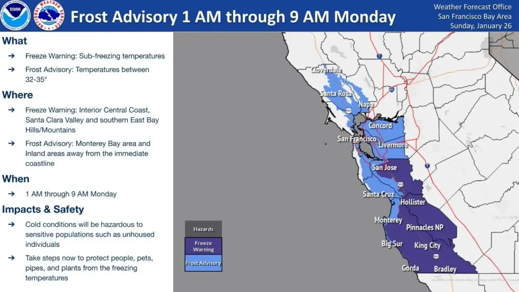
Image credit: NWS Bay Area
A Freeze Warning and a Frost Advisory have been issued for parts of the San Francisco Bay Area as a winter storm impacts much of Southern California.
The Frost Advisory and Freeze Warning will remain in effect from 01:00 to 09:00 local time (LT) on Monday, January 27.
The Interior Central Coast, Santa Clara Valley, and Southern East Bay Hills will remain under a Freeze Warning. They will experience below-freezing temperatures during the period.

Meanwhile, the Monterey Bay Area and inland regions away from the immediate coastline will remain under a Frost Advisory. These areas will experience temperatures between 0 and 1.7 °C (32 – 35 °F).
A Freeze Watch will take effect for the entirety of the Bay Area from 01:00 LT on Tuesday, January 28, to 09:00 LT on Thursday, January 30.
“The cold temperatures will cause hazardous conditions for unsheltered populations and those without access to adequate heating. Protect people, pets, plants, and pipes!” the National Weather Service (NWS) stated.
“A slow-moving closed upper low will linger over the southwestern U.S. through mid-week while a low pressure system strengthens at the surface,” NWS forecaster Dolan noted.
This low pressure system will bring chances for rain and mountain snow to the Southwest on Monday and Tuesday, January 27 and 28, then the system will push into the southern Plains on Wednesday.
Given the increased sensitivity from recent wildfires in southern California, moderate to locally heavy rain could lead to debris flows and flash flooding in burn scar areas today.
To the east, gusty winds and dry conditions will lead to elevated fire weather concerns for portions of Arizona and New Mexico today, but precipitation is expected to reduce fire weather concerns Tuesday into Wednesday.
References:
1 Short Range Forecast Discussion – NWS/WPC – January 27, 2025

I am an Assistant Editor and Severe Weather & Science Journalist at The Watchers, specializing in real-time severe weather coverage, geophysical event reporting, and research-driven scientific analysis. You can reach me at rishav(at)watchers(.)news.
Commenting rules and guidelines
We value the thoughts and opinions of our readers and welcome healthy discussions on our website. In order to maintain a respectful and positive community, we ask that all commenters follow these rules.