
Significant icing and heavy snow expected as major winter storm impacts U.S. from Central Plains to Mid-Atlantic
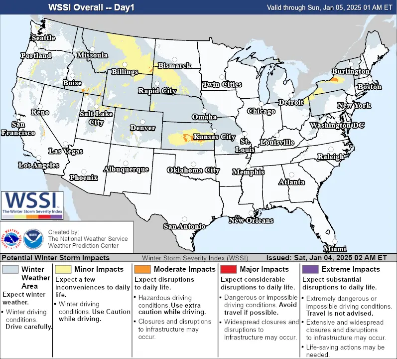
A major winter storm is forecast to affect approximately 50 million people across the United States this weekend, bringing heavy snow, blizzard conditions, and significant icing from the Central Plains to the Mid-Atlantic, starting Saturday, January 4, 2025. For some areas, this could be the heaviest snowfall in over a decade.

- A major winter storm is expected to affect nearly 50 million people across the United States, spanning regions from the Central Plains to the Mid-Atlantic, with severe weather conditions persisting from January 4 to January 6.
- Blizzard conditions with wind gusts exceeding 55 km/h (35 mph) and heavy snow are forecast in the Central Plains by Sunday, with some areas potentially experiencing their heaviest snowfall in over a decade. Snowfall totals of up to 30 cm (12 inches) are possible in multiple regions.
- Significant icing is expected south of the heavy snow axis, including southeastern Kansas, southern Missouri, southern Illinois, much of Kentucky, northeastern Tennessee, southwestern Virginia, and southern West Virginia, with ice accumulations of 2.5 mm to 6.3 mm (0.1 to 0.25 inches).
A major winter storm is set to impact much of the United States starting this weekend. The storm will reach the Central Plains late on Saturday, January 4, move into the Ohio Valley on Sunday, January 5, and continue into the Mid-Atlantic from Sunday night through Monday, January 6.
Blizzard conditions are expected in the Central Plains by Sunday morning, with wind gusts exceeding 55 km/h (35 mph) and heavy snowfall. Whiteout conditions will make driving highly dangerous or impossible, raising the risk of stranded travelers.
Heavy snow is forecast between central Kansas and Indiana, especially along and north of Interstate 70, with a strong likelihood of at least 20 cm (8 inches) of accumulation.
Hazardous sleet is forecast for eastern Kansas and the Ozarks, extending into the Ohio Valley, with significant icing likely in parts of the Central Appalachians through Sunday.
Travel conditions will be dangerous, and areas receiving over 6 mm (0.25 inches) of ice accumulations from freezing rain could face power outages.

Heavy snow is expected on Saturday across north-central to southeastern Montana and northwestern South Dakota. Winter storm warnings and weather advisories are in effect, with snowfall totals predicted to range from 10 – 15 cm (4 – 6 inches).
From Saturday night through Sunday, heavy snow and significant icing are forecast to develop across the Central Plains, Lower Missouri Valley, Mid-Mississippi Valley, and Ohio Valley.
Snowfall totals of 20 – 30 cm (8 – 12 inches) are possible from northeastern Kansas and southeastern Nebraska to northern Missouri, south-central Illinois, southern Indiana, northern Kentucky, and southern Ohio. This could be the heaviest snowfall in over a decade for these regions.
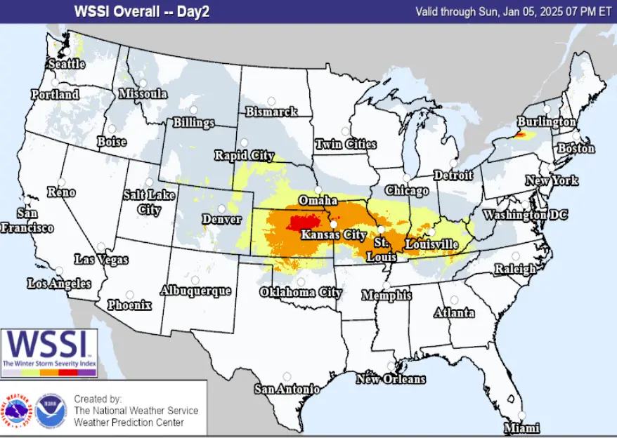
Significant icing is expected south of the heavy snow axis, including southeastern Kansas, southern Missouri, southern Illinois, much of Kentucky, northeastern Tennessee, southwestern Virginia, and southern West Virginia, with ice accumulations of 2.5 mm to 6.3 mm (0.1 to 0.25 inches).
Travel is expected to be extremely difficult and dangerous in areas with heavy snowfall and significant icing.
Heavy snowfall will extend into the Central Appalachians and the Mid-Atlantic by late Sunday night into Monday.
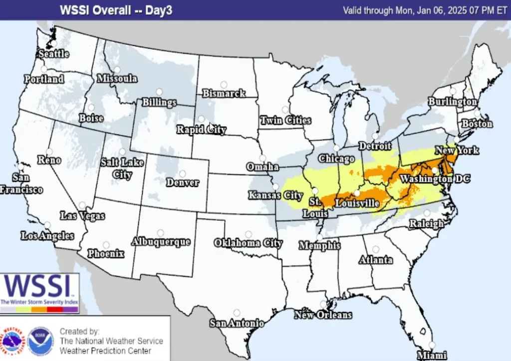
Heavy snowfall totals of 15 – 30 cm (6 – 12 inches) are expected across central and northern West Virginia, northern Virginia, most of Maryland, Washington, D.C., southern Pennsylvania, and much of Delaware. Traveling in these areas will be very difficult and dangerous.
Winter storm watches are in effect from the Central Plains to the Ohio Valley and will likely extend into the Mid-Atlantic.
Approximately 50 million people in the United States are under winter weather warnings, advisories, or watches.
References:
1 Short Range Public Discussion – NWS/WPC – January 4, 2024

I am an Assistant Editor and Severe Weather & Science Journalist at The Watchers, specializing in real-time severe weather coverage, geophysical event reporting, and research-driven scientific analysis. You can reach me at rishav(at)watchers(.)news.
Commenting rules and guidelines
We value the thoughts and opinions of our readers and welcome healthy discussions on our website. In order to maintain a respectful and positive community, we ask that all commenters follow these rules.