
Multiple tornadoes touch down in Texas, enhanced risk of severe thunderstorms continues on Saturday, U.S.
Several tornadoes touched down in southeastern Texas one day after Christmas, Thursday, December 26, 2024. NWS Storm Prediction Center is warning of an enhanced risk of severe thunderstorms on Saturday, December 28 across the East Texas/Lower Mississippi Valley to Tennessee Valley.
Multiple tornadoes were reported in southeastern Texas on Thursday, December 26. Local emergency managers confirmed three tornado sightings during the afternoon as severe storms moved through the state.
The Wharton County Office of Emergency Management reported that one tornado touched down near Highway 59, causing damage to several barns.
The National Weather Service (NWS) office in Houston reported that a spotter observed damage in Meadows, just across the Harris County line, caused by a brief tornado.
The NWS confirmed that a waterspout over Lake Houston moved onto land near Huffman. Shortly after, the NWS received a separate report of a tornado sighting northwest of Dayton.
No significant damages were associated with the tornadoes, but an impact assessment is underway.
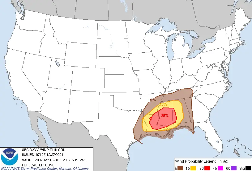
Enhanced severe weather risk continues across the southern United States on December 28
The National Weather Service (NWS) Storm Prediction Center has issued an enhanced risk warning for severe thunderstorms expected to impact regions from east Texas across the Lower Mississippi Valley and into parts of the Tennessee Valley on Saturday, December 28.
“An active severe-weather day is expected Saturday into Saturday night, with severe storms likely from east Texas across the Lower Mississippi Valley into parts of the Tennessee Valley,” NWS forecaster Guyer noted. ” Large hail, damaging winds, and tornadoes are likely, potentially including a few strong (EF2+) tornadoes.”
Meteorological overview
A potent southern-stream shortwave trough will traverse the southern Plains and extend toward the Ozarks and Mid-South by Saturday night. This will coincide with a significant strengthening of west-southwesterly winds in the lower atmosphere, exceeding 95 km/h (60 mph) in some areas at altitudes between 2 and 3 km (6 500 – 9 800 feet) above ground level.
The forecast dynamics indicate a conducive environment for severe weather, though scattered early-day convection and lingering cloud cover could introduce localized variability, particularly in the northernmost regions of the threat area. Despite these uncertainties, atmospheric conditions are primed for an increase in severe convection from east Texas to the ArkLaMiss region by late Saturday afternoon.
Key threats
Large hail
Initial storm development during the afternoon is likely to produce large hail, especially in isolated supercell structures.
Damaging winds
Strengthening low- and mid-level winds will enhance the risk of widespread damaging winds as storm systems organize into linear segments or bowing structures.
Tornadoes
The threat for tornadoes, including strong EF2+ tornadoes, will increase into the evening as low-level wind shear intensifies, with storm-relative helicity values reaching 200–400 m²/s².


Affected regions and timing
Initial development of severe storms is expected in East Texas and the ArkLaTex region by Saturday afternoon. These storms will feature a mix of semi-discrete supercells and organized lines capable of producing all severe weather hazards.
As the evening progresses, storms will intensify and move eastward, with a heightened risk for strong tornadoes and damaging winds.
Severe weather may persist into early Sunday morning, extending into parts of Alabama, the Florida Panhandle, and the Cumberland Plateau. The risk will remain significant even in areas with limited instability due to robust deep-layer wind shear and a powerful low-level jet of 50 – 65 knots (93 – 120 km/h; 58 – 75 mph).
Residents across the impacted regions should monitor weather updates closely, as this severe weather event could bring life-threatening conditions. Tornado watches and warnings, as well as severe thunderstorm advisories, are likely to be issued throughout the day.
References:
1 Multiple tornadoes sighted around southeastern Texas as severe storms march across South – Fox Weather – December 26, 2024
2 Convective Outlook – Day 2 – NWS/SPC – December 27, 2024 at 01:19 CST
Featured image credit: Texas Storm Chasers

I am an Assistant Editor and Severe Weather & Science Journalist at The Watchers, specializing in real-time severe weather coverage, geophysical event reporting, and research-driven scientific analysis. You can reach me at rishav(at)watchers(.)news.
Commenting rules and guidelines
We value the thoughts and opinions of our readers and welcome healthy discussions on our website. In order to maintain a respectful and positive community, we ask that all commenters follow these rules.