
Atmospheric river may stall, causing long-duration moderate to heavy rain over parts of Oregon
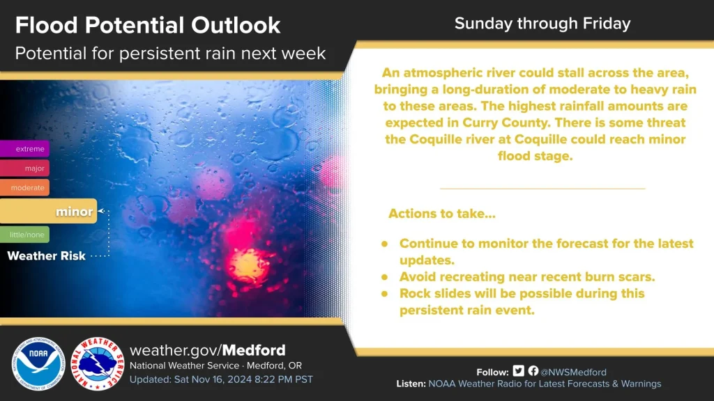
The National Weather Service (NWS) in Medford, Oregon, is warning residents that the incoming atmospheric river could stall across the region, leading to a prolonged period of moderate to heavy rainfall. The highest amounts are expected in Curry County, with a potential threat that the Coquille River at Coquille could reach a minor flood stage.

Image credit: NOAA/GOES-West, RAMMB/CIRA, The Watchers. Acquired at 17:10 UTC on November 17, 2024
An incoming atmospheric river is forecast to bring prolonged moderate to heavy rainfall to parts of Oregon from Tuesday, November 19 to Friday, November 22, with Curry County anticipated to receive the heaviest amounts.
The Coquille River at Coquille may reach a minor flood stage, and the continuous rain could lead to potential rockslides.
The National Weather Service (NWS) has advised residents to monitor forecasts for updates and avoid areas near recent burn scars.
According to the Center for Western Weather and Water Extremes (CW3E), about 70% of ECMWF EPS members predict AR4 or AR5 conditions in coastal southern Oregon. However, uncertainties remain regarding the timing and duration of the event.
The atmospheric river is also expected to affect southwestern Washington and northwestern Oregon, with rainfall totals potentially reaching up to 220 mm (8.65 inches) in some areas. According to NWS Portland, the wettest days are expected to be from Tuesday, November 19, to Friday.
Read more:
This event is preceded by a cold front which is expected to move into Oregon on Sunday evening, bringing 50 – 100 mm (2 – 4 inches) of snow at elevations between 760 – 1 070 m (2 500 – 3 500 feet) by Monday morning, November 18, with up to 460 mm (18 inches) possible in the high Cascades by Monday night.
Snow levels will initially be at 2 130 m (7 000 feet) ahead of the front on Sunday afternoon before dropping to 910 m (3 000 feet) between 19:00 and 21:00 local time (LT) on Sunday. NWS Medford has warned of travel delays and disruptions across the Cascades and along Highway 97 during this event.

According to NWS Pendleton, 250 – 510 mm (10 – 20 inches) of snow is expected along the Cascade passes through Monday night, prompting a significant level 4 weather risk on a scale of 5.
In addition, a strong area of low pressure is forecast to produce numerous weather hazards across the central United States beginning November 17. The storm system is expected to organize over West Texas before moving into the central Plains by November 18. The system is expected to bring severe thunderstorms, heavy rainfall, and snow to various regions through midweek.
A strong influx of atmospheric moisture from the western Gulf of Mexico is anticipated to create favorable conditions for thunderstorms. Western and central Texas, along with southwest Oklahoma, are expected to experience damaging wind gusts and isolated tornadoes through early November 18. The Storm Prediction Center has highlighted this region as having the highest risk for severe weather.
A stationary boundary extending from the central Plains into the low-pressure center will provide a corridor for concentrated rainfall. Flood Watches are in effect from northwest Texas to central Oklahoma, with flash flooding possible in these areas. As the storm moves northward into the Upper Midwest by November 19, heavy rainfall is expected to expand into the region.
Snowfall is likely in North Dakota, with periods of heavy snow expected through November 20. The system’s tight pressure gradient could also generate strong winds across the central United States early this week, potentially affecting travel and infrastructure.
Heavy rainfall is a concern for the central and eastern Gulf Coast, where an approaching cold front will interact with tropical moisture from dissipating Tropical Storm “Sara” over Belize. Eastern Louisiana to the Florida Panhandle is expected to receive at least 51 mm (2 inches) of rain, with some areas facing a 70 – 90% likelihood of these amounts.
Significant temperature contrasts are forecast across the nation in the days ahead, with below-normal temperatures prevailing in the West and above-normal temperatures dominating the East. Dry conditions are anticipated along much of the East Coast, central High Plains, and the Southwest through November 20.
References:
1 Short Range Forecast Discussion – NWS/WPC – November 17, 2024

I am an Assistant Editor and Severe Weather & Science Journalist at The Watchers, specializing in real-time severe weather coverage, geophysical event reporting, and research-driven scientific analysis. You can reach me at rishav(at)watchers(.)news.
Commenting rules and guidelines
We value the thoughts and opinions of our readers and welcome healthy discussions on our website. In order to maintain a respectful and positive community, we ask that all commenters follow these rules.