
Model predicts major atmospheric river for Pacific Northwest and Northern California
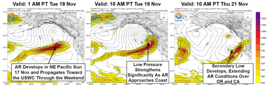
The latest model guidance suggests a major atmospheric river could hit the Pacific Northwest and Northern California early next week, with the ECMWF EPS control member forecasting AR3-4 conditions from central Oregon to Northern California. Although timing and duration remain uncertain, 70% of EPS members predict AR4 or AR5 conditions in coastal southern Oregon, according to the Center for Western Weather and Water Extremes (CW3E).

Image credit: NOAA/GOES-West, Zoom Earth, The Watchers. Acquired at 05:50 UTC on November 16, 2024.
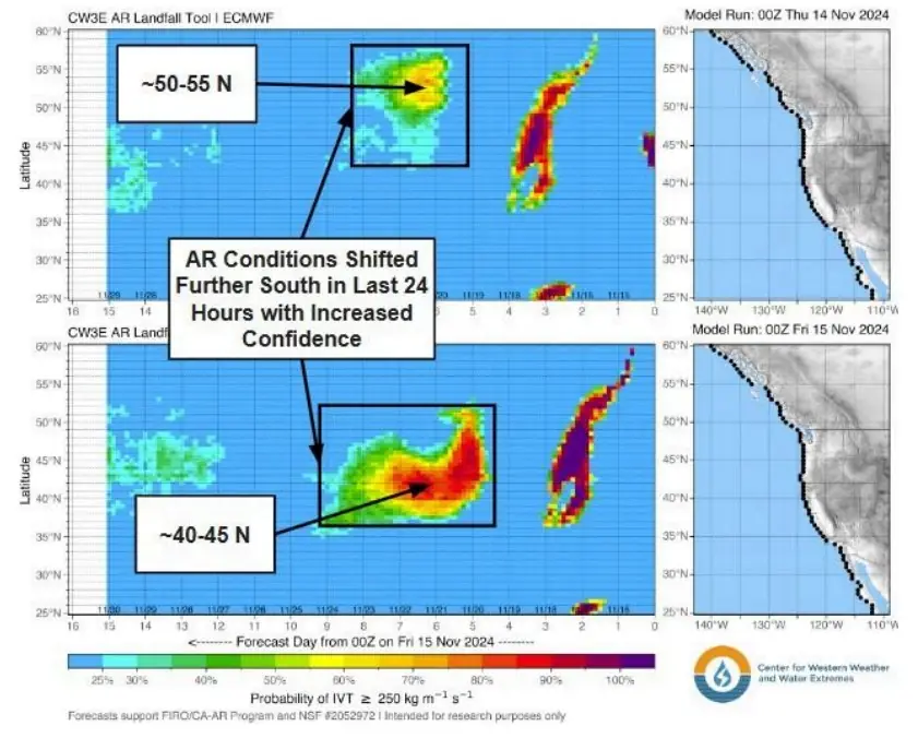
CW3E’s atmospheric river (AR) landfall tool is showing a high likelihood (>80% probability) of landfalling AR activity over the Pacific Northwest and Northern California beginning late Tuesday, November 19 and continuing throughout at least Friday, November 22.
The forecast has undergone a significant shift since November 14, when the ECMWF model projected AR activity over southeastern Alaska and British Columbia, influenced by ridging over the US West Coast. Recent model runs indicate that weaker ridging and its center moving further inland have caused the AR’s track to change substantially.
For next week, AR3-4 conditions are predicted to extend from central Oregon southward into northern California.
While the exact timing and duration of the event remain uncertain, approximately 70% of ECMWF EPS members forecast (major) AR4 or AR5 for coastal southern Oregon.
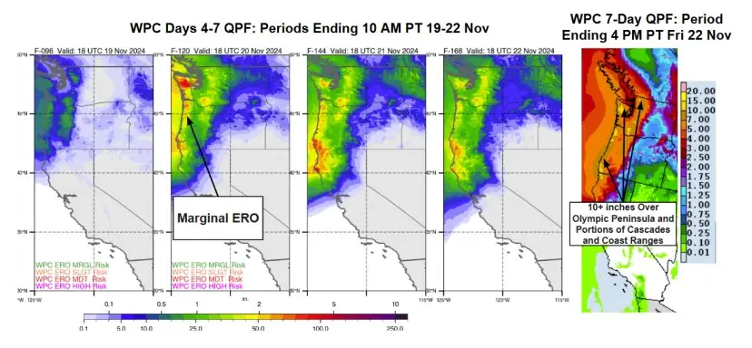
Over the next seven days, the AR event could bring up to 127 mm (5 inches) of precipitation to the Cascades and coastal regions of Washington, Oregon, and northern California.
The heaviest precipitation—exceeding 254 mm (10 inches)—is forecast for the Olympic Peninsula, parts of the Cascades, and the Coast Ranges, according to the Weather Prediction Center (WPC).
Different weather models project varying areas for the highest precipitation totals. The ECMWF model identifies the California-Oregon border as the area with the most significant 7-day precipitation, whereas the GFS model suggests the Oregon Coast will see the greatest totals.
Additionally, the WPC has issued a marginal risk of flash flooding, with a 5% probability, for coastal Washington and Oregon during a 24-hour period ending at 04:00 local time (LT) on November 20.
CW3E forecasters are urging residents living in areas under forecast to stay alert to official National Weather Service forecasts, watches and warnings at weather.gov and follow guidance from local emergency management officials.
References:
1 Quick Look at the Potential AR Landfall Over the Pacific Northwest and California Next Week – CW3E – November 15, 2024

I am an Assistant Editor and Severe Weather & Science Journalist at The Watchers, specializing in real-time severe weather coverage, geophysical event reporting, and research-driven scientific analysis. You can reach me at rishav(at)watchers(.)news.
Commenting rules and guidelines
We value the thoughts and opinions of our readers and welcome healthy discussions on our website. In order to maintain a respectful and positive community, we ask that all commenters follow these rules.