
Severe Tropical Cyclone “Judy” – Red Alert in effect for Penama, Malampa, Shefa, and Tafea provinces, Vanuatu
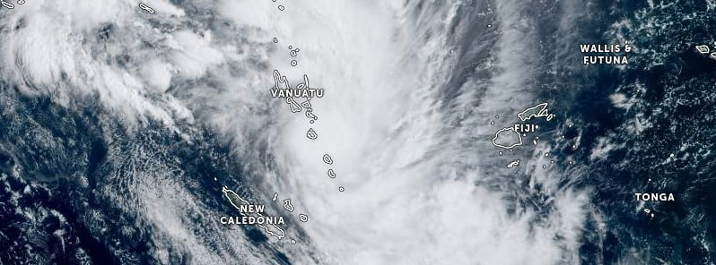
Featured image: Severe Tropical Cyclone "Judy" at 22:50 UTC on February 28, 2023. Credit: JMA/NOAA, Zoom Earth, The Watchers
Category 3 – Severe Tropical Cyclone “Judy” is expected to bring destructive winds and heavy rainfalls to Vanuatu’s central and southern islands.
- A Red Alert is in effect for Penama, Malampa, Shefa, and Tafea provinces, Yellow for Sanma, and Blue for Torba province.
- People living in affected regions are advised to continue to listen to Radio Vanuatu and all other radio outlets to get the latest warning on this system.
At 21:00 UTC on February 28 (08:00 LT, March 1), the center of severe tropical cyclone “Judy” was located about 35 km (22 miles) north northeast of Efate and 165 km (102 miles) north northwest of Erromango.
Maximum winds close to the center are estimated at 165 km/h (103 mph).
The system had a minimum central pressure of 954 hPa and was moving south at 15 km/h (9 mph).
Destructive hurricane-force winds of 150 km/h (93 mph), gusting to 200 km/h (124 mph), will affect the central and southern islands, while destructive storm-force winds of 110 km/h (68 mph), gusting to 150 km/h (93 mph), will affect 150 km (92 miles) northeast and southeast from the center of the system.
Damaging gale-force winds of 63 to 87 km/h (39 to 54 mph) are expected over the provinces of Penama, Malampa, Shefa, and Tafea today.
Heavy rainfalls and thunderstorms are expected over central, southern, and parts of the northern islands with flash flooding expected in low-lying areas and areas close to the river banks, including coastal flooding today.
Seas will become rough, very rough to phenomenal with heavy to very heavy swells expected over Vanuatu waters. A high seas warning is current for the open coastal waters of Vanuatu.
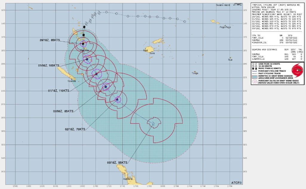
Forecast positions:
| Date and Time | Position | Intensity |
|---|---|---|
| +06 hours (14:00 LT, March 1) | 18.4S, 168.8E (near Efate) | 90 knots (165 km/h; 103 mph) |
| +12 hours (20:00 LT, March 1) | 19.5S, 169.3E (near Efate) | 90 knots (165 km/h; 103 mph) |
| +18 hours (02:00 LT, March 2) | 20.5S, 169.9E (near Efate) | 90 knots (165 km/h; 103 mph) |
| +24 hours (08:00 LT, March 2) | 21.5S, 170.5E (near Efate) | 80 knots (150 km/h; 93 mph) |
| +36 hours (20:00 LT, March 2) | 23.5S, 171.9E (near Tanna) | 60 knots (110 km/h; 68 mph) |
| +48 hours (08:00 LT, March 3) | 25.3S, 173.5E (near Aniwa) | 50 knots (95 km/h; 59 mph) |
| +60 hours (20:00 LT, March 3) | 27.0S, 176.0E (near Aneityum) | 40 knots (75 km/h; 47 mph) |
| +72 hours (08:00 LT, March 4) | 28.6S, 179.3E (southwest of Vanuatu) | 40 knots (75 km/h; 47 mph) |
Judy is the 4th named storm of the 2023 South Pacific cyclone season.
References:
1 Tropical Cyclone Warning Number 15 – Vanuatu Meteorology and Geo-hazards Department, Port Vila – 22:15 UTC on February 28, 2023 (09:15 VUT on March 1, 2023)
I'm a dedicated researcher, journalist, and editor at The Watchers. With over 20 years of experience in the media industry, I specialize in hard science news, focusing on extreme weather, seismic and volcanic activity, space weather, and astronomy, including near-Earth objects and planetary defense strategies. You can reach me at teo /at/ watchers.news.
Commenting rules and guidelines
We value the thoughts and opinions of our readers and welcome healthy discussions on our website. In order to maintain a respectful and positive community, we ask that all commenters follow these rules.