
Red Alert in Vanuatu, Lola becomes southern hemisphere’s earliest Category 5 tropical cyclone on record
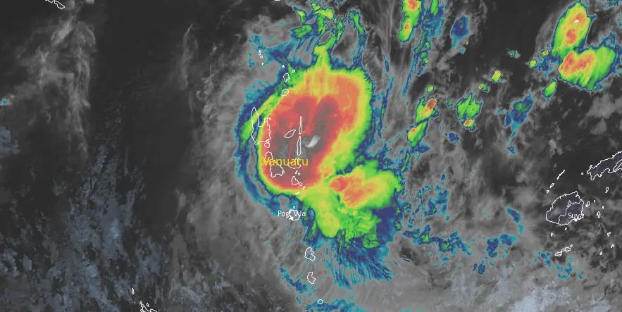
Featured image: Tropical Cyclone "Lola" at 13:00 UTC on October 24, 2023. Credit: JMA/Himawari-9, RAMMB/CIRA, The Wathers
The center of Tropical Cyclone “Lola” approached the islands of Maewo, Pentecost, and Ambae in Vanuatu at around 12:00 UTC on October 24, 2023, with maximum sustained winds of 185 km/h (115 mph). Maximum one-minute sustained winds were recorded at 205 km/h (125 mph), gusting up to 250 km/h (155 mph). The minimum barometric pressure was 941 hPa.
- Very destructive hurricane-force winds of 230 km/h (140 mph), gusting to 320 km/h (200 mph) are expected to affect Torba, Sanma, and Penama in the next 24 hours.
- A Red Alert is now in effect for Torba, Sanma, Penama, Malampa, and Shefa, and a Blue alert for Tafea Province.
- People in Torba, Sanma, Penama, Malampa, Shefa, and Tafea provinces should listen to all Radio Outlets to get the latest information on this system.
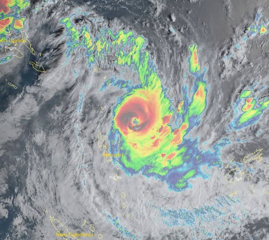
Lola formed on October 21, 2023, ten days before the official start of the 2023/24 South Pacific cyclone season. By October 23, the storm had intensified into a Category 3 severe tropical cyclone. It further intensified into Category 4 by 12:00 UTC the same day, with a maximum ten-minute sustained winds of 175 km/h (110 mph).
By 18:00 UTC on October 23, Lola’s maximum sustained winds reached 215 km/h (135 mph). At the same time, the Fiji Meteorological Service upgraded the system to a Category 5 severe tropical cyclone. As a result, Lola became the earliest Category 5 tropical cyclone on record in the southern hemisphere. Lola’s eye then quickly disappeared, signaling a phase of rapid weakening.
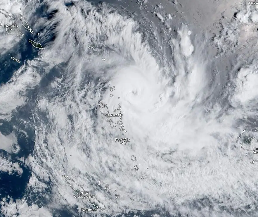
At 12:00 UTC on October 24 (23:00 LT), the center of Severe Tropical Cyclone “Lola” (Category 4) was located about 30 km (18 miles) north of Pentecost and 30 km south of Maewo, according to the Vanuatu Meteorology & Geohazards Department. “Lola has moved in a southwest direction at 18 km/h (11 mph) in the past 3 hours. The central pressure of the system is estimated at 941 hPa.”
Winds close to the center are estimated at 165 km/h (100 mph), gusting up to 189 km/h (117 mph) within 30 km (18 miles) from the center of the system.
Very destructive hurricane-force winds of 230 km/h (140 mph), gusting to 320 km/h (200 mph) are expected to affect Torba, Sanma, and Penama in the next 24 hours.
Destructive storm force winds of 185 km/h (115 mph) gusting to 265 km/h (165 mph) are within 166 km (103 miles) from the center of the system and will affect Torba, Sanma, Penama, Malampa, and Shefa later today. Damaging gale force winds of 93 km/h (58 mph) with gusts up to 105 km/h (65 mph) are between 74 to 185 km (45 to 115 miles) from the center of the system and will continue to affect Torba, Sanma, Penama, Malampa, and Shefa province today as well.
Heavy rainfalls with flash flooding are expected over low-lying areas and areas close to river banks, including coastal flooding over the Vanuatu group today and continuing tomorrow. Very rough seas with heavy to phenomenal swells are expected over all Vanuatu waters.
Marine strong wind warning is current for all Vanuatu waters. Storm surge is expected along the eastern coastlines of the affected Northern islands. High Seas Wind Warning is also current for the Northern Quadrants of Vanuatu.
People, including seagoing vessels, are advised to take extra precautions.
The office of the NDMO advises that a Red Alert is now in effect for Torba, Sanma, Penama, Malampa, and Shefa, and a Blue alert for Tafea Province.
People in Torba, Sanma, Penama, Malampa, Shefa, and Tafea provinces should listen to all Radio Outlets to get the latest information on this system.
The Vanuatu government convened an inter-agency briefing to plan an emergency response. Evacuations have commenced in Santo Island and other parts of northern Vanuatu, according to the Vanuatu Red Cross.
JTWC forecasters stated at 09:00 UTC on October 24 that Lola is already entering its rapid weakening phase and forecast models suggest that this may be one of the most dramatic cases of rapid weakening on record.
Analysis of the most recent animated imagery suggests that Lola has slowed down to a crawl as it approaches Pentecost Island, but without a clear view below the central dense overcast (CDO), or surface observations, it is impossible to tell if the low-level circulation center (LLCC) has passed Pentecost Island yet or not, JTWC said at 15:00 UTC.
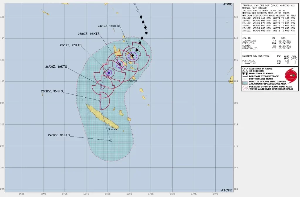
Additional erratic motion can be expected as the system moves into the area between Pentecost and Malekula islands but overall the system is forecast to track southwest along the periphery of the steering ridge to the east, through the next 36 hours.
Around 18:00 UTC on October 25, Lola is expected to turn towards the south and then eventually southeast by 09:00 UTC on October 27, as it tracks along the gradient between the subtropical ridge to the northeast and an approaching mid-latitude low pressure system moving in from the west.
Only a naked remnant vortex is expected to pass over New Caledonia between October 26 and 27.
Update
October 25
Power and communication networks have been cut, making it difficult to report the impact at this stage.
Vanuatu’s National Disaster Management Office (NDMO) has activated offices in six provinces, ready to carry out a rapid assessment after the cyclone. 300 evacuation centers with many located in schools and churches were set up throughout Vanuatu. Port Vila, the capital, is on red alert and all government offices, markets, and banks are closed until further notice.
Heavy rainfalls with flash flooding are expected over low-lying areas and areas close to river banks, including coastal flooding. Very rough seas with heavy to phenomenal swells are expected over all Vanuatu waters.
October 27
The International Federation of Red Cross (IFRC) and media report that approximately 10 000 houses have been damaged and a number of schools and bridges destroyed. There has also been damage to the road network across the Penama, Malampa, Sanma, and Torba provinces. The Pentecost Island in Penama Province is the worst affected area.
References:
1 Severe Tropical Cyclone Warning Number 15 issued by the Vanuatu Meteorology and Geo-hazards Department, Port Vila at 12:09am VUT Wednesday 25 October 2023 for TORBA, SANMA, PENAMA, MALAMPA & SHEFA Province.
2 Tropical Cyclone 01P (Lola) Warning #11 – JTWC – Issued at 24/0900Z
I'm a dedicated researcher, journalist, and editor at The Watchers. With over 20 years of experience in the media industry, I specialize in hard science news, focusing on extreme weather, seismic and volcanic activity, space weather, and astronomy, including near-Earth objects and planetary defense strategies. You can reach me at teo /at/ watchers.news.
Commenting rules and guidelines
We value the thoughts and opinions of our readers and welcome healthy discussions on our website. In order to maintain a respectful and positive community, we ask that all commenters follow these rules.