
Tropical Cyclone “Lola” intensifies as it approaches Vanuatu, poses threat to southern New Caledonia
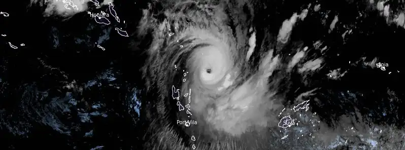
Featured image: Tropical Cyclone "Lola" at 12:50 UTC on October 23, 2023. Credit: JMA/Himawari-9, RAMMB/CIRA, The Watchers
Tropical Cyclone “Lola” formed on October 21, 2023, as the first named storm of the 2023/24 South Pacific cyclone season. It formed 10 days before the official start of the season. The cyclone is intensifying as it moves south toward Vanuatu.
On October 23 at 05:00 UTC, Tropical Cyclone “Lola” was located approximately 230 km (143 miles) northeast of Vanua Lava Island in Torba Province, northern Vanuatu, and 385 km (239 miles) northeast of Luganville City in Espiritu Santo Island, central Vanuatu.
According to the Joint Typhoon Warning Center (JTWC), Lola had maximum sustained winds of 175 km/h (110 mph) and was moving southward at a speed of 13 km/h (8 mph) at 09:00 UTC.
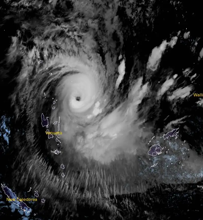
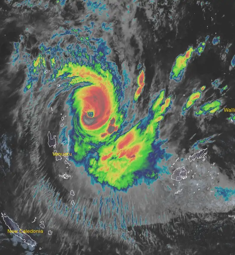
Animated multispectral satellite imagery (MSI) shows a medium-sized system with rain bands wrapping in tighter from all quadrants into a symmetrical cold dense overcast with deepening and overshooting cloud tops and has maintained a ragged and elongated 28 km (17 miles) wide eye.
The forecast indicates that the cyclone will continue to move southwestward, passing between the Espiritu Santo and Malekula Islands on the afternoon of October 24 with maximum sustained winds ranging between 130 km/h and 145 km/h (81 mph and 90 mph). The cyclone is expected to affect southern New Caledonia on October 27 – 28, transitioning into a tropical storm by that point.
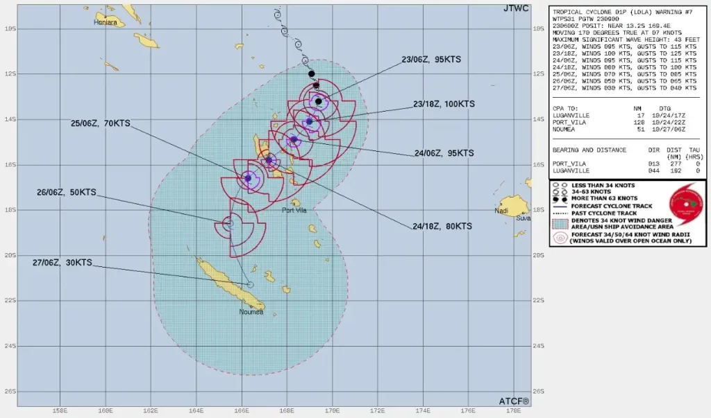
Lola is expected to bring very heavy rainfall, strong winds, and storm surges over the entire region of Vanuatu in the next 72 hours. The sea wave height is predicted to reach up to 13 m (43 feet).
The cyclone is currently in a highly favorable environment with low vertical wind shears and sea surface temperatures ranging between 28 °C and 29 °C (82 – 84 °F).
Numerical models predict that the cyclone will track more southwestward as the near-equatorial ridge to the east builds. After 72 hours, a shortwave trough approaching from the southwest is expected to weaken the ridge, allowing the system to move more southward. The favorable environmental conditions are likely to fuel a steady intensification to a peak of 180 km/h (115 mph) by 18:00 UTC today.
Residents and authorities in Vanuatu and southern New Caledonia should be prepared for severe weather conditions, including heavy rainfall, strong winds, and storm surges over the next few days.
References:
1 Tropical Cyclone 01P (Lola) Warning #07 – JTWC – Issued on 09:00 UTC on October 23, 2023
I'm a dedicated researcher, journalist, and editor at The Watchers. With over 20 years of experience in the media industry, I specialize in hard science news, focusing on extreme weather, seismic and volcanic activity, space weather, and astronomy, including near-Earth objects and planetary defense strategies. You can reach me at teo /at/ watchers.news.
Commenting rules and guidelines
We value the thoughts and opinions of our readers and welcome healthy discussions on our website. In order to maintain a respectful and positive community, we ask that all commenters follow these rules.