
Severe Tropical Cyclone “Mal” approaches Fiji, evacuation centers open on Viti Levu
Featured image: Tropical Cyclone "Lan" at 15:00 UTC on November 14, 2023. Credit: JMA/Himawari-9, RAMMB/CIRA, The Watchers
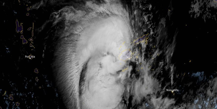
Tropical Cyclone “Mal” formed near the Solomon Islands in the South Pacific Ocean on November 10, 2023, as the second named storm of the 2023/24 South Pacific Ocean cyclone season. The system is moving SE toward Fiji and is expected to pass close the eastern coast of Viti Levu Island in the late afternoon (UTC) of November 14.
At 12:00 UTC on November 14, the center of Severe Tropical Cyclone “Mal” was located about 140 km (85 miles) west-southwest of Viwa Island and 185 km (115 miles) west of Nadi, Fiji. It had a maximum 10-minute sustained winds of 120 km/h (75 mph), with gusts up to 165 km/h (105 mph). Maximum 1-minute sustained winds were at 120 km/h (75 mph). The minimum central barometric pressure was 970 hPa, and the system was moving south-southeast at 30 km/h (18 mph).
Several evacuation centers were already preventively opened across the Viti Levu Island by national authorities.
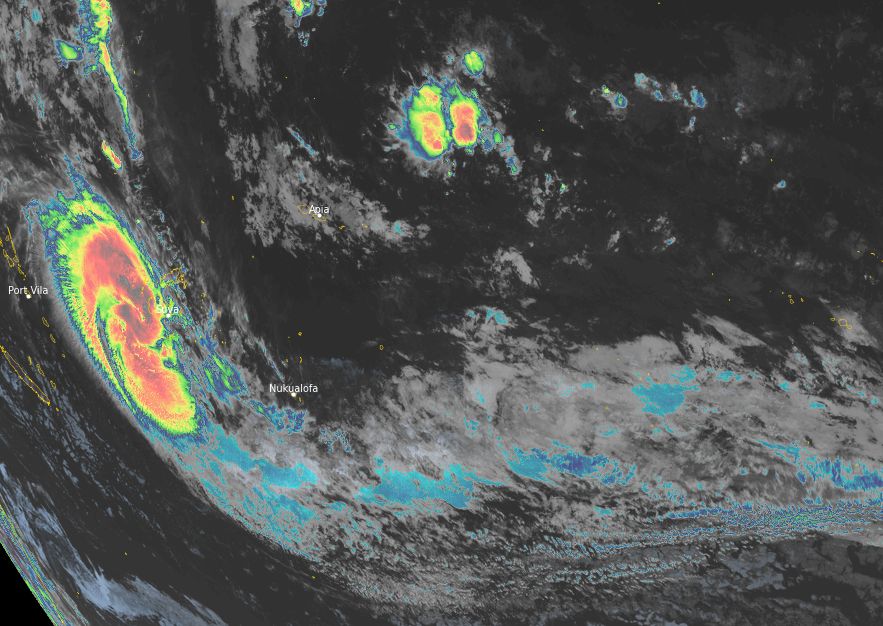
Mal is expected to continue moving south-southeast, slightly strengthening, and to pass close to the eastern coast of Viti Levu Island late afternoon (UTC) of November 14, with maximum sustained winds up to 120 km/h (75 mph). After that, it is forecast to continue southeastward on November 15 – 17, further weakening and dissipating.
Over the next 24 hours, heavy rainfall, strong winds and storm surge are forecast over most of Viti Levu Island. The Fiji Meteorological Service has issued an Orange warning for gales over the whole Island.
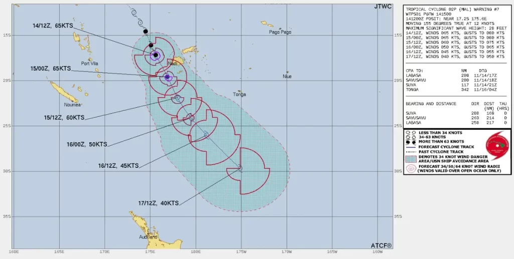
Tropical Cyclone “Lan” remains situated under a belt of moderate upper-level northwesterlies, which is exerting pressure on the northern periphery of the system. Despite this pressure, the system appeared to be consolidating until about 11:10 UTC today with a more symmetric central dense overcast (CDO) and colder cloud top temperatures, JTWC forecasters said at 15:00 UTC on November 14.
Since 11:10 UTC today, animated enhanced infrared satellite imagery revealed a quickly fragmenting, more asymmetric appearance with warming cloud top temperatures. This rapid cycling of core convection is expected to continue over the next 12 hours, aided by robust poleward outflow and warm sea surface temperatures.
Lan is forecast to track south-southeastward along the southwestern periphery of the subtropical ridge STR over the next 36 hours. The system should maintain intensity at 120 km/h (75 mph) but could possibly intensify slightly higher over the next 12 hours due to enhanced poleward outflow into the subtropical jet.
Between 03:00 UTC on November 15 and 00:00 UTC on November 16, vertical wind shear (VWS) will increase to high levels, which will lead to a steady weakening trend. As the system recurves around the STR after midnight UTC, November 16, VWS will increase to 120 km/h (75 mph) as the system begins to interact with the subtropical jet (STJ) and commences subtropical transition (STT). STT will complete over the next 48 to 72 hours as the system interacts with a weak baroclinic zone and tracks under the STJ.
References:
1 Tropical Cyclone 02P (Mal) Warning #07 – JTWC – Issued at 14/1500Z
2 Fiji – Tropical cyclone MAL – DG ECHO – November 14, 2023
I'm a dedicated researcher, journalist, and editor at The Watchers. With over 20 years of experience in the media industry, I specialize in hard science news, focusing on extreme weather, seismic and volcanic activity, space weather, and astronomy, including near-Earth objects and planetary defense strategies. You can reach me at teo /at/ watchers.news.
Commenting rules and guidelines
We value the thoughts and opinions of our readers and welcome healthy discussions on our website. In order to maintain a respectful and positive community, we ask that all commenters follow these rules.