
Warnings in place ahead of Tropical Cyclone “Ana” landfall, Fiji
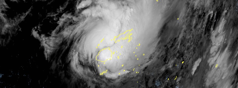
Featured image: Tropical Cyclone "Ana" at 11:40 UTC on January 30, 2021. Credit: JMA/Himawari-8, RAMMB/CIRA, TW
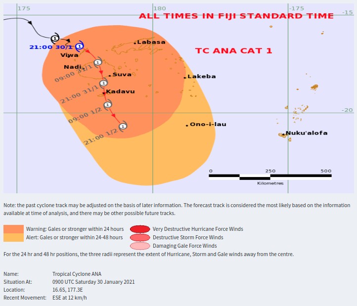
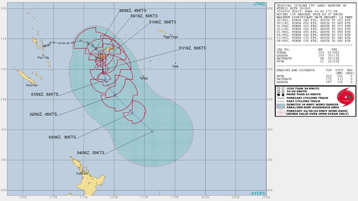
Tropical Storm "Ana" formed late January 29, 2021 west of Fiji as the third named storm of the 2020/21 South Pacific cyclone season. The system is expected to make landfall over Ra Province on Sunday morning (LT), January 31, and slow down as it moves over Fiji.
At 06:00 UTC (18:00 LT) on January 30, the center of Category 1 Tropical Cyclone "Ana" was located about 80 km (50 miles) WNW of Yasawa-I-Rarta or about 160 km (100 miles) NNW of Nadi, Fiji. The cyclone was moving SE at about 9 km/h (6 mph).
Heavy rain is already falling over the country and is expected to continue and become more frequent as the cyclone draws closer. This will cause flooding of roads, villages, towns, and communities near streams, rivers, and low lying areas. Due to continuous rain in the last few days causing soil in the ground to become moist and loose, this poses the risk of landslides.
Therefore, all communities living in flood and landslide-prone areas need to remain alert and take precautions when necessary, the Fiji Meteorological Service (FMS) said.
In 24 hours to 09:00 LT on January 30 (21:00 UTC, January 29) Nadarivatu recorded 436 mm (17.1 inches) of rain, Navala 315 mm (12.4 inches), Toge 249 mm (9.8 inches), Bukuya 245 mm (9.6 inches), Navunitawa 241 mm (9.5 inches), Nanoko 230 mm (9 inches), and Nagado 185 mm (7.3 inches).
A Tropical Cyclone Warning and Heavy Rain warning is in force for the whole Fiji Group.
A Gale Warning is in force for the whole group and all Fiji Waters, and Strong Wind Warning for Rotuma and the waters of Rotuma.
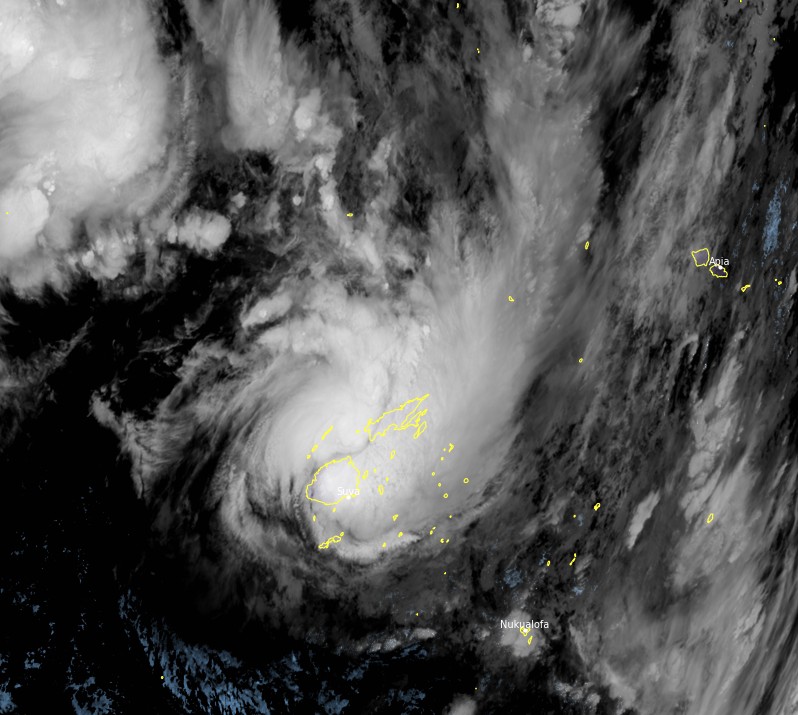
Tropical Cyclone "Ana" at 11:40 UTC on January 30, 2021.
Image credit: JMA/Himawari-8, RAMMB/CIRA, TW
A Flood Warning remains in force for all low lying areas and areas adjacent to small streams and major rivers of Viti Levu and Qawa River as well as for rivers along Bua through Nabouwalu to Kubulau in Vanua Levu.
A Flash Flood Warning remains in force for all low lying areas and areas adjacent to small streams and creeks for Fiji.
Areas included in the flash flood warning for Vanua Levu are Nabouwalu to Labasa, Nabouwalu to Kubulau, Dawara to Nabalebale Village along the Wailevu West Coast Road, Naibalebale Village to Savusavu, Savusavu to Natewa and Tunuloa, Koroalau to Saqani, and Saqani to Labasa.
Areas included in the flash flood warning for Vitilevu are Low lying areas from Sigatoka through Lautoka to Rakiraki, Semo, Naiwaicoba, Nadi Back Road, Lomolomo and Barara Flats, Navutu Flats, Lovu, Saru Back Road, Vuda Back Road, Koronubu Flat, Namosau, Veisari, Baravu Flats and Nailaga areas, Nausori, Naqali, Serua, Korovou, and Lodoni.
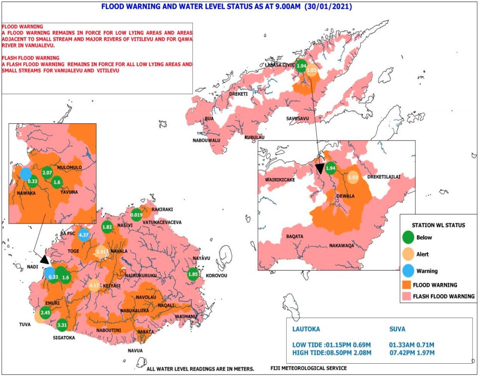
Flood Warning and Water Level Map at 09:00 LT, January 30, 2021. Credit: Fiji Meteorological Service
In its anticipated track, Ana's eye is expected to be located closer to the Yasawa Group tonight and approach Viti Levu early Sunday, January 31 (LT, UTC+12) whilst remaining as a category 1 cyclone, according to RSMC Nadi.
The cyclone is likely to make landfall over Ra Province around tomorrow morning (LT) then continue to move southeastwards over Viti Levu and track close to Kadavu around tomorrow night to Monday morning.
Please be advised that damaging winds are likely to begin several hours before the cyclone center passes overhead or nearby.
Gale force winds have already been reported over Yasawa-i-Rara this morning (LT) and are expected to affect the rest of the Fiji Group from later today.

Damages to weak structures and houses of very light materials are expected, FMS said. It may also cause disruption of electrical power distribution and communication services.
Damages to crops and vegetation with trees tilting due to very strong winds are also likely.
Heavy rain is expected to continue and become more frequent as the cyclone draws closer to Fiji. This will cause flooding of roads, villages, towns, and communities near streams, rivers, and low lying areas.
Due to continuous rain in the last few days causing soil in the ground to become moist and loose, this poses the risk of landslides.
Therefore, all communities living in flood and landslide-prone areas need to remain alert and take precautions when necessary.
Members of the public are advised to keep away from flooded drains, streams, and rivers whilst motorists are also requested to take extreme care when driving as there is a risk of poor visibility in areas of heavy rain and thunderstorms.
Moderate swells and breaking waves reaching the coastal areas may cause possible coastal inundation and sea flooding, especially during high tide.
Sea conditions are too dangerous for sea travel, sailing, and other sea activities.
The current situation is closely monitored, FMS said, and advised members of the public to remain updated with the latest weather information and adhere to authorities on the ground.
I'm a dedicated researcher, journalist, and editor at The Watchers. With over 20 years of experience in the media industry, I specialize in hard science news, focusing on extreme weather, seismic and volcanic activity, space weather, and astronomy, including near-Earth objects and planetary defense strategies. You can reach me at teo /at/ watchers.news.
Commenting rules and guidelines
We value the thoughts and opinions of our readers and welcome healthy discussions on our website. In order to maintain a respectful and positive community, we ask that all commenters follow these rules.