
Complex, long-duration winter storm for the Midwest and Mid-Atlantic/Northeast, U.S.
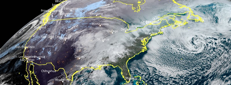
Image credit: NOAA/GOES-East, RAMMB/CIRA. Acquired at 14:20 UTC on January 30, 2021
A complex winter storm will start today, January 30, 2021, in the Midwest with heavy snow from the Upper Mississippi Valley to the Ohio Valley, including the Chicago metro area. On Sunday, January 31, the snow and wintry mix will spread into the Mid-Atlantic region before a potential Nor'easter intensifies and significantly impacts portions of the Mid-Atlantic, Northeast, and New England on Monday and Tuesday, February 1 and 2.
- A prolonged winter storm is expected to begin this evening in the Midwest and persist into early next week for the Northeast, NWS WPC warns.
- Heavy snowfall is expected across the Midwest tonight into Sunday, with snowfall also spreading across the Central Appalachians and into the Mid-Atlantic. Additional heavy snow is likely for the Mid-Atlantic and the Northeast Monday into Tuesday.
- Uncertainty remains, especially across the Mid-Atlantic and Northeast, so the locations and amounts of heaviest snowfall may change in the coming days.
- Heavy snow accumulating to 150 mm (6 inches) is expected in the Midwest through Sunday.
- Freezing rain is likely in North Carolina, West Virginia, and Virginia with heavy snow forecast from Virginia to Maine into early next week.

Credit: NWS/WPC
A storm exiting the Rockies will emerge across the Central High Plains eventually moving eastward to the Mid-Atlantic Coast by Monday morning, NWS forecaster Ziegenfelder said.
Moisture from the Western Gulf of Mexico will move northward over the Southern Plains into the Mississippi Valley with rain expanding into the Middle/Lower Mississippi Valley by this afternoon as the system moves out of the Rockies and into the Plains.
The rain will move eastward into parts of the Ohio/Tennessee Valley overnight and into the Southeast/Mid-Atlantic by Sunday morning.
Meanwhile, snow will develop over parts of the Northern Plains/Upper Mississippi Valley through today. By this evening, the snow will expand into parts of the Upper Great Lakes and the Ohio Valley.
Along the rain/snow line, rain/freezing rain areas will also develop from the Middle Mississippi Valley into the Ohio Valley and into the Central Appalachians and adjacent foothills.
Overnight, snow will move into southern portions of the Mid-Atlantic.
There will be areas of rain/freezing rain over parts of western Virginia and North Carolina on Sunday.
While the snow will wane over the Upper Midwest overnight Sunday, it will continue over the Ohio Valley, parts of the Great Lakes, and into the Mid-Atlantic through Monday morning.
The rain over the Southeast will shift offshore by Monday morning.
Meanwhile, in the West, multiple fronts will move into the Pacific Northwest/Northern California today. The boundaries will have a plume of moisture associated with them, streaming moisture into the Northwest/Northern California.
The systems will produce rain and higher elevation snow over the Pacific Northwest and Northern California, continuing through Monday morning.
The rain will be heavy over parts of Northern California.
I'm a dedicated researcher, journalist, and editor at The Watchers. With over 20 years of experience in the media industry, I specialize in hard science news, focusing on extreme weather, seismic and volcanic activity, space weather, and astronomy, including near-Earth objects and planetary defense strategies. You can reach me at teo /at/ watchers.news.
You call the Fimbulwinter a Complex, long-duration winter storm? It lasts three years don’t you know?