
SPC issues Enhanced Risk for severe thunderstorms across Montana, Wyoming, North Dakota, and South Dakota
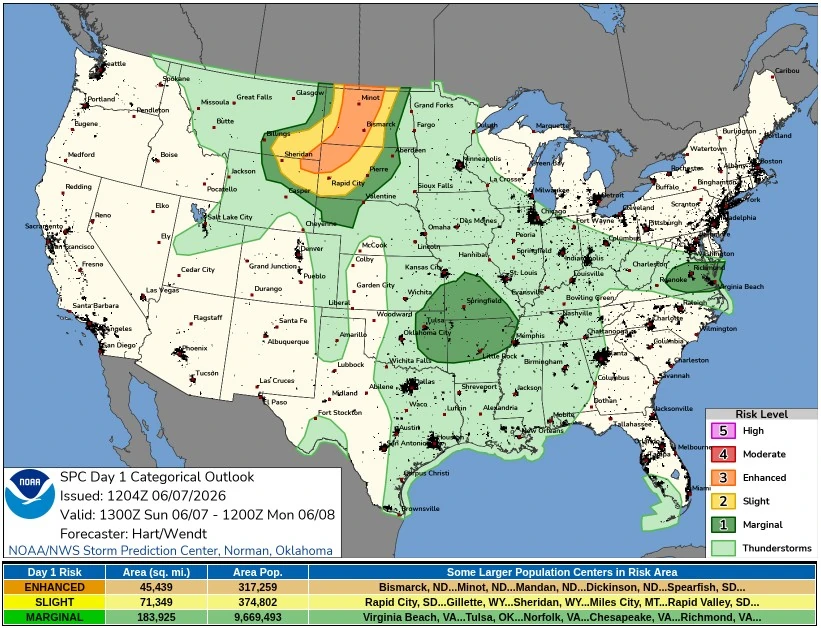
The Storm Prediction Center (SPC) issued an Enhanced Risk for severe thunderstorms across parts of southeast Montana, northeast Wyoming, and the western Dakotas on June 7, 2026. Damaging wind gusts, large hail, and an isolated tornado threat are expected this afternoon and evening.
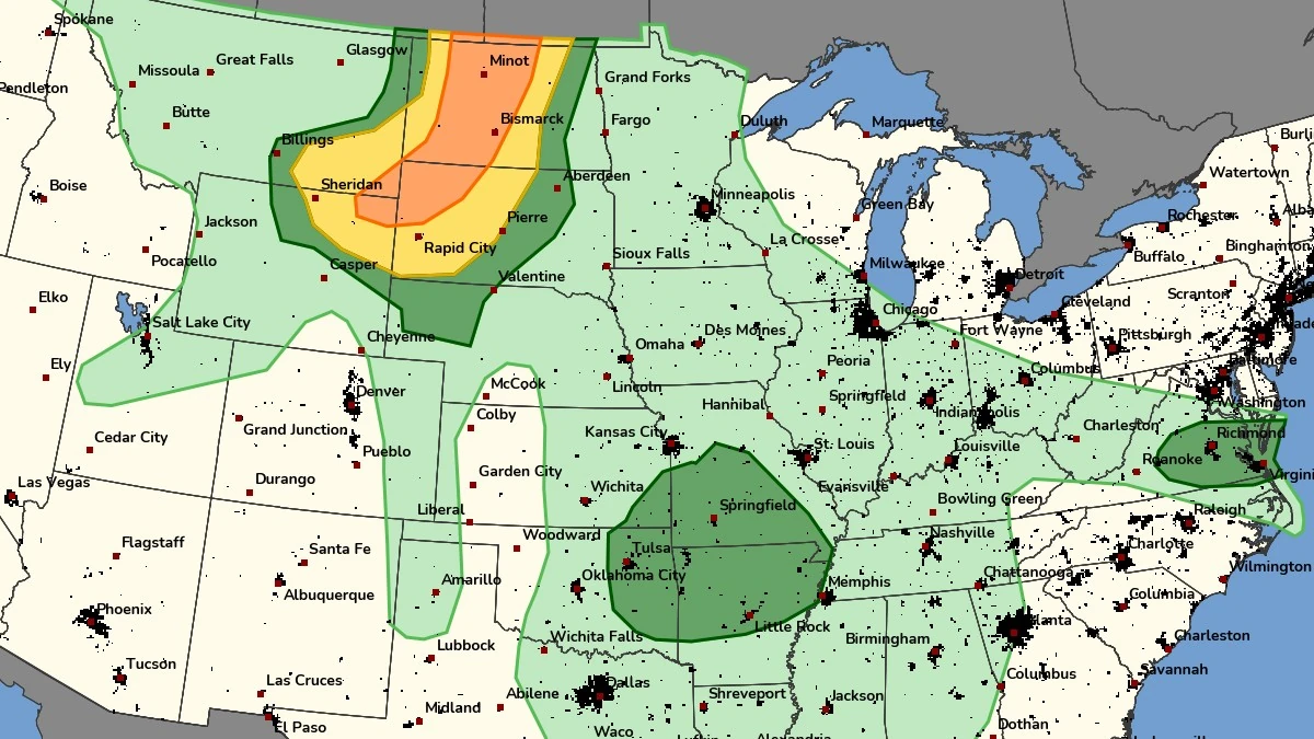
Day 1 Convective Outlook valid from 13:00 UTC on June 7 to 12:00 UTC on June 8, 2026. Credit: NWS/SPC
A strong upper trough over the northern Great Basin will move eastward on June 7, support cyclogenesis over eastern Wyoming, and focus a surface cold front from south-central Wyoming into northwest North Dakota.
Thunderstorms are expected to form by mid-afternoon near the Bighorn Mountains and build eastward across southeast Montana. Steep low-level lapse rates and moderate CAPE values will support large hail and damaging winds, with storms becoming more numerous and intense as they spread into western South Dakota during the evening, according to SPC.
The National Weather Service (NWS) office in Bismarck said scattered to numerous severe thunderstorms are forecast over much of western and central North Dakota late this afternoon and tonight. The office warned of hail up to 5.1 cm (2 inches) and wind gusts near 113 km/h (70 mph), with deep-layer shear and very steep lapse rates supporting supercell development over western North Dakota before storms are expected to transition quickly into a linear system.
The NWS office in Rapid City said a cold front moving slowly through western South Dakota and northeastern Wyoming will bring showers and thunderstorms today and tonight, with severe storms possible.
Discrete storms are forecast to develop across northeastern Wyoming early in the afternoon, with supercell structure, large hail, damaging winds, and a brief tornado threat before storms form into a line later in the evening, and damaging winds become the main threat.
NWS Billings said severe thunderstorms are possible over southeastern Montana and north-central Wyoming this afternoon and early evening, especially across the eastern half of its forecast area and the southeast. The office placed the main timing from 13:00–19:00 MDT on June 7 (19:00 UTC on June 7 to 01:00 UTC on June 8), with large hail, damaging winds, and an isolated tornado risk in far southeast Montana.
Outside the Enhanced Risk area, an isolated threat for tornadoes and severe wind gusts will be possible across the Ozarks, where a weak cut-off low over Oklahoma and southwesterly mid-level winds will overlap deep moisture.
Strong wind gusts will be possible in the mid-Mississippi Valley and across southeast Virginia and northeast North Carolina, where scattered thunderstorms are expected near a weak surface cold front.
References:
1 Day 1 Convective Outlook – NWS/SPC – June 7, 2026
I'm a dedicated researcher, journalist, and editor at The Watchers. With over 20 years of experience in the media industry, I specialize in hard science news, focusing on extreme weather, seismic and volcanic activity, space weather, and astronomy, including near-Earth objects and planetary defense strategies. You can reach me at teo /at/ watchers.news.
Commenting rules and guidelines
We value the thoughts and opinions of our readers and welcome healthy discussions on our website. In order to maintain a respectful and positive community, we ask that all commenters follow these rules.