
Small earthquakes and ground deformation continue at Taupo volcano, New Zealand
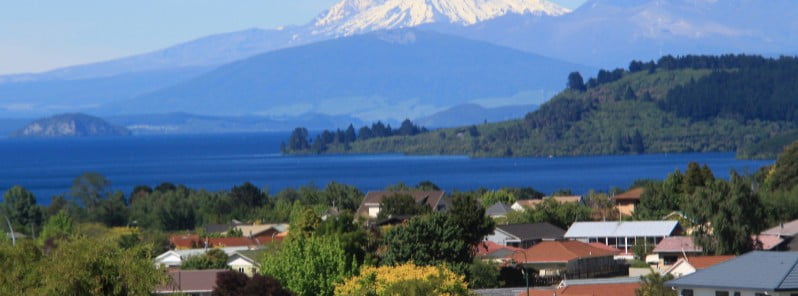
Image credit: Georgie Sharp
Minor volcanic unrest continues at New Zealand’s Taupō volcano, as shown by continued small earthquakes and ground deformation. The Volcanic Alert Level remains at 1. While Volcano Alert Level 1 is mostly associated with environmental hazards, the potential for eruption hazards also exists.
The earthquakes and deformation at Lake Taupō have continued since the last bulletin issued by GeoNet on October 11, 2022.1
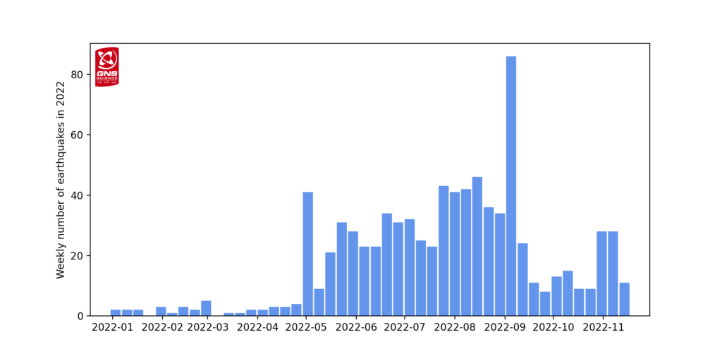
The rate of earthquake activity has varied since the increase started in May. After a peak of about 30 – 40 events per week from June to September, the number of earthquakes dropped over the last month to about 10 – 12 per week.
The number has now risen again, over the last two weeks, to a little over 20 events per week.
GeoNet has located 840 earthquakes since the start of 2022, mainly at depths from 4 to 13 km (2.5 – 8 miles) beneath the center of Lake Taupō.
The earthquakes in the last 2 weeks, the largest of which was M3.6 on November 4, have been concentrated in the central portion of the lake, south of Horomatangi Reef.
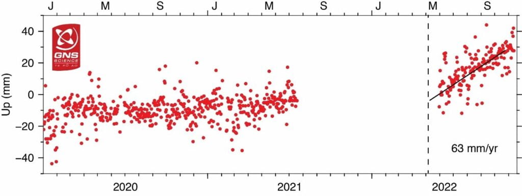
In addition to seismic activity, GeoNet volcanologists continuously monitor ground deformation (land movement) around Lake Taupō.
Their GNSS (GPS) instruments around the lake continue to observe both horizontal and vertical changes. A site on Horomatangi Reef in the center of the lake indicates that uplift at a rate of approximately 60 ± 20 mm (2.3 ± 0.8 inches) per year has continued since May 2022.
“We interpret the ground deformation and earthquake activity to be caused by activity associated with magma and hydrothermal fluids inside the volcano,” GeoNet Duty Volcanologist Paul Jarvis said.1
“This activity could continue for the coming weeks or months at varying rates or intensities. While some of the earthquakes have been felt in areas around Lake Taupō, the deformation is currently only detectable by our sensitive ground-based monitoring instruments.”
In broad terms, such volcanic unrest occurs when magma or magma-heated hot water and steam moves deep within the ground beneath a volcano, changing the stresses there and producing earthquakes and ground movement. There have been 17 previous episodes of unrest at Taupō over the past 150 years and none have resulted in an eruption, Jarvis noted.
The Volcanic Alert Level (VAL) was raised to Level 1 for Taupō Volcano on September 20, 2022. This was based on the current data but was also supported by new knowledge from research programs on volcanic eruptions and unrest at Taupō Volcano.
While Volcano Alert Level 1 is mostly associated with environmental hazards, the potential for eruption hazards also exists.
Geological summary
Taupo, the most active rhyolitic volcano of the Taupo volcanic zone, is a large, roughly 35 km (21 miles) wide caldera with poorly defined margins. It is a type example of an “inverse volcano” that slopes inward towards the most recent vent location.
The caldera, now filled by Lake Taupo, largely formed as a result of the voluminous eruption of the Oruanui Tephra about 22 600 years before present (BP).
This was the largest known eruption at Taupo, producing about 1 170 km3 (281 mi3) of tephra. This eruption was preceded during the late Pleistocene by the eruption of a large number of rhyolitic lava domes north of Lake Taupo.
Large explosive eruptions have occurred frequently during the Holocene from many vents within Lake Taupo and near its margins.
The most recent major eruption took place about 1 800 years BP from at least three vents along a NE-SW-trending fissure centered on the Horomotangi Reefs. This extremely violent eruption was New Zealand’s largest during the Holocene and produced the thin but widespread phreatoplinian Taupo Ignimbrite, which covered 20 000 km2 (7 722 mi2) of North Island.2
References:
1 Minor unrest ongoing at Taupō Volcano. Volcanic Alert Level remains at Level 1 – GeoNet – November 16, 2022
2 Taupo – Geological summary – GVP
I'm a dedicated researcher, journalist, and editor at The Watchers. With over 20 years of experience in the media industry, I specialize in hard science news, focusing on extreme weather, seismic and volcanic activity, space weather, and astronomy, including near-Earth objects and planetary defense strategies. You can reach me at teo /at/ watchers.news.
Commenting rules and guidelines
We value the thoughts and opinions of our readers and welcome healthy discussions on our website. In order to maintain a respectful and positive community, we ask that all commenters follow these rules.