
Large violent tornado hits Pembroke, Georgia

Image credit: Live Storms Media (stillshot)
A violent tornado moved through areas in central Georgia on Tuesday, April 5, 2022, leaving at least one person dead and several injured. Severe weather, with heavy rain, damaging winds and tornadoes, is expected to continue across the Southeast section of the U.S., including the Atlanta metro area, today.
“A large wedge tornado with horizontal vortices cut a swath through an area just north of Pembroke,” Live Storms Media reports.
“We were one of the 1st on scene and started to do search and rescue. There were multiple injuries and victims trapped under-leveled homes.”
The tornado ripped part of the roof from the Bryan County courthouse, destroyed the entrance to a local government building across the street and damaged homes in nearby neighborhoods, said Matthew Kent, a county government spokesman.1
At least one person was killed and several others were injured in the county, Kent said.
Another person was killed in eastern Texas yesterday when storm winds toppled a tree onto a home in Whitehouse, about 160 km (100 miles) southeast of Dallas. Officials said trees fell on at least four homes there.
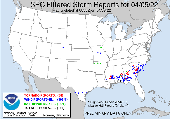
The Pembroke tornado was a part of widespread severe storms affecting the U.S. Southeast on Tuesday.
The Storm Prediction Center is reporting 38 tornadoes and 14 large hail events on April 5.
This round of severe weather, with heavy rain, damaging winds and tornadoes, is expected to continue across the Southeast section of the U.S., including the Atlanta metro area.
Enhanced risk of severe thunderstorms for parts of the southern Appalachians into the southeastern U.S.
Severe thunderstorms capable of producing swaths of damaging gusts, severe hail, and several tornadoes are expected across a broad area from parts of the southern Appalachians into the southeastern U.S. this afternoon, NWS foreecasters Moore and Smith noted.2
A robust upper-level wave is noted in early-morning water vapor imagery over the northern CONUS. At the surface, an attendant surface low is beginning to occlude over the upper MS river valley. A progressive cold front arcing from the Midwest into the southern Plains will continue to sweep east/southeast over the next 24 hours. Ahead of this front, a diffuse warm front will advance north into the Great Lakes region by the late afternoon, establishing a broad warm sector from the Gulf Coast into the Ohio River Valley
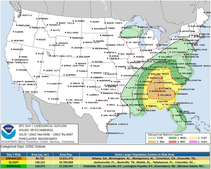
Middle TN into the OH River Valley
Ongoing thunderstorms along the cold front in the mid-MS valley will move into the middle TN/OH river valley through the day.
Low-level moisture will gradually increase as the warm front mixes north. Dewpoints in the mid to upper 50s are expected as far north as northern KY ahead of the front and will support MLCAPE values near 1000 J/kg.
The upper-level jet streak overhead will support strong 50-60 knot effective bulk shear, and storm motions vectors near to just off the cold front may support a mix of supercells and bowing segments. Elongated hodographs in the 0-3 km layer will support a tornado threat with any discrete cells
Southern Appalachians into the Southeast
The cold front is expected to move across the lower MS valley through the morning hours. Morning inhibition and weaker forcing for ascent may limit storm coverage until the front reaches MS/AL around early afternoon when diurnal heating/mixing can overcome lingering capping.
Deep-layer shear will be more marginal compared to locations farther north, but 30-40 knot in the 1-2 km layer will still support a damaging wind threat with storms along the front.
To the east across southeast AL and southern GA, the guidance suggests an outflow boundary lingering from last night’s MCS will lift through the region. Thunderstorms will likely develop along this boundary by late morning as inhibition erodes via insolation between cloud breaks and low-level warm advection.
Forecast hodographs show mid to upper-level flow weakness, but low-level curvature will support 150-250 m2/s2 effective SRH across the region.
This will support a tornado threat, especially during the early afternoon when isolated to scattered quasi-discrete supercells are most probable prior to gradual clustering.
While CAM guidance shows the highest probabilities for convection across southeast AL into southern GA, the exact location of convective initiation remains somewhat uncertain.
References:
1 Violent storms kill at least 2 people in Georgia, Texas – AP
2 Day 1 Convective Outlook – NWS Storm Prediction Center Norman OK – 1215 AM CDT Wed Apr 06 2022
I'm a dedicated researcher, journalist, and editor at The Watchers. With over 20 years of experience in the media industry, I specialize in hard science news, focusing on extreme weather, seismic and volcanic activity, space weather, and astronomy, including near-Earth objects and planetary defense strategies. You can reach me at teo /at/ watchers.news.
Commenting rules and guidelines
We value the thoughts and opinions of our readers and welcome healthy discussions on our website. In order to maintain a respectful and positive community, we ask that all commenters follow these rules.