
Earthquake swarm under Davidof volcano, U.S.
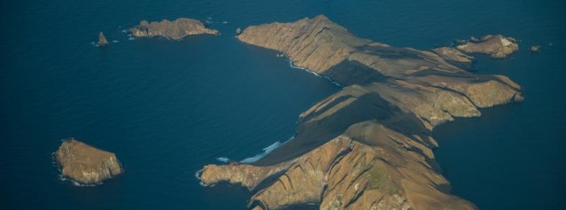
Featured image: Davidof and Khvostof Islands in November 2012. Image credit: Roger Clifford.
Due to the possibility of escalating volcanic events associated with a swarm of earthquakes in the vicinity of Davidof volcano in Alaska, the Alaska Volcano Observatory (AVO) has raised the Aviation Color Code and the Volcano Alert Level for Davidof volcano to Yellow/Advisory on December 10, 2021. There is no known eruption of this volcano over the past 10 000 years.
A swarm of earthquakes occurred in the vicinity of Davidof volcano during the latter part of the week and was still ongoing as of 23:02 UTC on December 10, when AVO released its latest weekly update.1
The largest earthquake to date happened at about 19:45 UTC on December 10 and had a magnitude of 4.2. This swarm may be associated with volcanic unrest or it could also be due to regional tectonic activity, AVO said.
Due to the possibility of escalating volcanic unrest, AVO raised the Aviation Color Code and Volcano Alert Level for Davidof to YELLOW/ADVISORY.
AVO continues to monitor the situation with seismometers deployed on nearby islands since there is no real-time seismic monitoring network at Davidof volcano. The closest seismometers to Davidof are approximately 13 km (8 miles) to the east of the volcano on Little Sitkin Island.
Davidof volcano is a mostly submerged stratovolcano in the Rat Islands group in the western Aleutian Islands, about 350 km (218 miles) west of Adak.
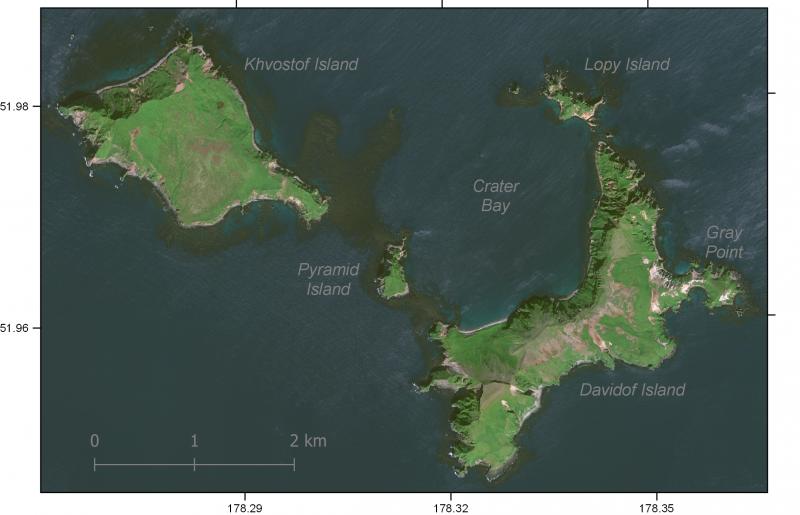
GeoEye-1 satellite image of Davidof volcano from 2020. Thick pumice and pyroclastic deposits are visible as light-colored areas exposed by Gray Point on the east side of Davidof Island. Crater Bay is a submerged 2.5 km (1.5 miles) diameter caldera. Credit: Matt Loewen
Geological summary
A cluster of small islands between Segula and Little Sitkin in the western Aleutians, the largest of which is Davidof, are remnants of a stratovolcano that collapsed during the late Tertiary, forming a 2.7 km (1.7 miles) wide caldera.
The islands include Khvostof, Pyramid, Lopy, and Davidof; the latter three form the eastern rim of the mostly submarine caldera, sometimes referred to as the "Aleutian Krakatau."
The islands were constructed above a roughly 100 m (330 feet) deep submarine platform extending NW to Segula Island; the floor of the caldera lies 80 m (262 feet) below sea level.
The islands are vegetated, but lava flows are recognizable, and Smith et al. (1978) suggested a possible Holocene age.
This volcano is located within the Aleutian Islands, a UNESCO Biosphere Reserve property.2
References:
1 ALASKA VOLCANO OBSERVATORY WEEKLY UPDATE U.S. Geological Survey Friday, December 10, 2021, 2:02 PM AKST (Friday, December 10, 2021, 23:02 UTC)
2 Davidof – Geological summary – GVP
I'm a dedicated researcher, journalist, and editor at The Watchers. With over 20 years of experience in the media industry, I specialize in hard science news, focusing on extreme weather, seismic and volcanic activity, space weather, and astronomy, including near-Earth objects and planetary defense strategies. You can reach me at teo /at/ watchers.news.
Commenting rules and guidelines
We value the thoughts and opinions of our readers and welcome healthy discussions on our website. In order to maintain a respectful and positive community, we ask that all commenters follow these rules.