
Antarctic blast to bring sub-zero temperatures, powerful swells, frost and snow, New Zealand
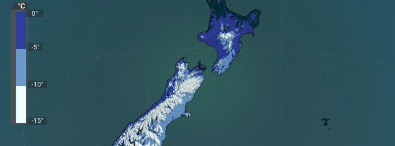
Image credit: NIWA
The New Zealand MetService is forecasting a blast of Antarctic air rolling over the country in the next few days, bringing sub-zero temperatures, powerful swells, strong winds, frost, and snow.
- Not even the 'winterless north' will escape the wrath of the Polar blast, NIWA said.
- Temperatures are expected to drop by 10 °C (18 °F) in some places. The cold will remain after the snow leaves, with settled weather paving the way for overnight temperatures to plummet.
- Expect very large, high-energy waves and frosts with single-digit or sub-zero temperatures.
With strengthening southerly winds for the South Island, south to southwest swells of 6 to 8 m (20 – 26 feet) are expected on June 28 and 29, with a period of 15 seconds for nearly all of the South Island.
These powerful waves will continue to spread up the coasts of the North Island, with Wellington expecting to see 6 m (20 feet) high swells from Tuesday morning, June 29 and other coastal areas a few hours later.
"These are very large, high-energy waves, and can catch people unawares if they're walking on beaches or driving along coastal roads," said MetService meteorologist Alwyn Bakker. "There's also the potential for waves to affect land or property near coasts."
Tuesday’s temperatures: not even the “winterless north” will escape the wrath of the polar blast! pic.twitter.com/KC2Ht7bAF7
— NIWA Weather (@NiwaWeather) June 28, 2021
Despite a very warm June thus far, the month is going to end with plunging temperatures and wintry weather as southerlies bring us an air mass direct from Antarctica.
Make sure your coat, gloves, and hat are ready to go this week, because temperatures are going pic.twitter.com/IpRbduSA2R
— NIWA Weather (@NiwaWeather) June 27, 2021
When you combine Tuesday’s temperatures and winds, this is what you get.
Better (we think!) than 46.6°C in British Columbia, Canada, yesterday, the country’s hottest temperature on record! pic.twitter.com/zNjxznY2WH
— NIWA Weather (@NiwaWeather) June 28, 2021
The winds driving the swell are also a potential risk, with a rash of wind Watches out over the country. Exposed places on the south and east coasts of the South Island may see severe gales at times.
Parts of Nelson, Wellington and the Marlborough Sounds, and the east coast of the North Island from the Wairarapa to Napier are also at risk.
Many in the lower South Island woke up to a dusting of white this morning, with snow down to 200 m (650 feet) in parts of Southland and Otago, and more is expected tomorrow.
"As the polar blast washes over Te Waipounamu/South Island, snow levels will lower to 100 or 200 m (330 – 650 feet) in the south and east, and 600 m (2 000 feet) in the north," Bakker said.
"Aside from Northland, Auckland, and Hamilton, Te Ika-a-Maui/North Island will also see snow levels between 300 and 500 m (1 000 – 1 600 feet) tomorrow."
Driving conditions may be hazardous, and high-level roads will be particularly affected, so keep up to date with MetService's Road Snowfall Warnings.
The cold temperatures will remain after the snow leaves, with settled weather paving the way for overnight temperatures to plummet.
Expect frosts with single-digit or sub-zero temperatures.
I'm a dedicated researcher, journalist, and editor at The Watchers. With over 20 years of experience in the media industry, I specialize in hard science news, focusing on extreme weather, seismic and volcanic activity, space weather, and astronomy, including near-Earth objects and planetary defense strategies. You can reach me at teo /at/ watchers.news.
Commenting rules and guidelines
We value the thoughts and opinions of our readers and welcome healthy discussions on our website. In order to maintain a respectful and positive community, we ask that all commenters follow these rules.