
Tropical Cyclone “Choi-wan” (Dante) to make landfall over Batangas Province, Philippines
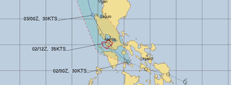
Image credit: TW
Tropical Cyclone "Choi-wan" will make landfall over Batangas Province, Philippines at around 09:00 UTC (17:00 LT) on June 2, 2021, and traverse western and central Luzon over the next 2 days. Prolonged heavy rains have already flooded parts of Mindanao, leaving 3 people dead and one missing. DOST-PHIVOLCS has issued lahar advisory for Mayon volcano on June 1, and Taal and Pinatubo volcanoes on June 2, 2021.
Tropical Storm "Choi-wan" — known as Dante in the Philippines — formed at 00:00 UTC on May 31 as the third named storm of the 2021 Pacific typhoon season.
The storm made its first landfall at 12:30 UTC on June 1 over Sulat, Eastern Samar as a minimal tropical storm. JTWC downgraded it to a tropical depression at 15:00 UTC, two hours before its second landfall over Cataingan.
Heavy rains produced by the storm have already flooded parts of Mindanao, leaving at least 3 people dead and one missing on June 1. Classes and government work for parts of Davao de Oro, Eastern Samar, Leyte, and Surigao del Sur were suspended.

Tropical Storm "Choi-wan" (Dante) on June 1, 2021. Credit: NASA/NOAA Suomi NPP/VIIRS
At 06:00 UTC on June 2, Tropical Cyclone "Choi-wan" (Dante) was about 255 km (160 miles) southeast of Manila, Philippines. Its maximum 10-minute sustained winds were 65 km/h (40 mph) at the time, with gusts up to 95 km/h (60 mph).
Maximum 1-minute sustained winds were 55 km/h (35 mph) and the minimum central barometric pressure 1 002 (hPa). The system was moving north-northwest at 25 km/h (15 mph).
Based on DOST-PAGASA Tropical Cyclone Bulletin No. 18 issued at 00:00 UTC (08:00 LT) on June 2, 2021, Choi-wan will make landfall over Batangas Province today at 09:00 UTC (17:00 LT) and traverse western and central Luzon over the next 2 days.
Gale-force winds are extending up to 50 km (31 miles) from the center.

Tropical Cyclone Wind Signal No. 2 is in effect for the northern portion of Romblon (Corcuera, Banton, Concepcion), Marinduque, the northern and central portion of Oriental Mindoro (Roxas, Bongabong, San Teodoro, Puerto Galera, Baco, City of Calapan, Naujan, Victoria, Socorro, Pola, Pinamalayan, Gloria, Bansud), the northern and central portion of Occidental Mindoro (Sablayan, Santa Cruz, Paluan, Mamburao, Abra de Ilog, Lubang Islands), Batangas, Cavite, Bataan, the southwestern portion of Bulacan (Calumpit, Bulacan, City of Malolos, Paombong, Hagonoy), the western portion of Pampanga (Masantol, Macabebe, Sasmuan, Lubao, Floridablanca, Porac, Guagua, Santa Rita, Angeles City, Mabalacat City, Minalin, Bacolor), Zambales, the western portion of Tarlac (Bamban, Capas, San Jose, Mayantoc, Camiling, Santa Ignacia, San Clemente),and the western portion of Pangasinan (Bolinao, Anda, Bani, Agno, Burgos, Infanta, Dasol, City of Alaminos, Mabini, Sual, Labrador, Bugallon, Aguilar, Mangatarem, Bayambang, Urbiztondo, Basista, Malasiqui, San Carlos City, Santa Barbara, Mangaldan, Dagupan City, Calasiao, Binmaley, Lingayen).
Tropical Cyclone Wind Signal No. 1 is in effect for the rest of Romblon, the rest of Oriental Mindoro, the rest of Occidental Mindoro, the western portion of Quezon (Sampaloc, Mauban, Lucban, City of Tayabas, Candelaria, San Antonio, Tiaong, Dolores, Sariaya, Pagbilao, Lucena City, Atimonan, Padre Burgos, Agdangan, Pitogo, Unisan, Gumaca, Lopez, Plaridel, Macalelon, Catanauan, General Luna, Buenavista, Mulanay, San Narciso, San Andres, San Francisco), Laguna, Metro Manila, Rizal, the rest of Bulacan, the rest of Pampanga, the rest of Tarlac, the western portion of Nueva Ecija (Cabiao, San Antonio, City of Gapan, San Isidro, San Leonardo, Jaen, Zaragoza, Licab, Guimba, Cuyapo, Nampicuan, Talugtug, Quezon, Aliaga, Santa Rosa), the rest of Pangasinan, the southern portion of Benguet (Itogon, Tuba, Sablan, Baguio City, La Trinidad, Kapangan, Tublay), and La Union.
Today through tomorrow morning, June 3 (LT), Choi-wan is forecast to produce moderate to heavy with at times intense rains over Calabarzon, Romblon, Marinduque, Occidental Mindoro, Oriental Mindoro, Aklan, Antique, Capiz, Bataan, Zambales, and Pangasinan.
Moderate to heavy rains are expected over the rest of Central Luzon, Metro Manila, the northern portion of Palawan including Calamian, Cuyo, and Cagayancillo Islands, Iloilo, and Guimaras.
Light to moderate with at times heavy rains are expected over Bicol Region, Benguet, Nueva Vizcaya, Quirino, Negros Occidental, and the rest of MIMAROPA.
Under these conditions and considering antecedent rainfall, scattered to widespread flooding (including flash floods) and rain-induced landslides are expected, especially in areas with high or very high susceptibility to these hazards as identified in hazard maps, PAGASA warns.
Adjacent or nearby areas may also experience flooding in the absence of such rainfall occurrence due to surface runoff or swelling of river channels.
Strong winds to gale-force winds are possible over the areas where Tropical Cyclone Wind Signal #2 is hoisted. Such conditions may bring generally light to moderate damage to structures and vegetation.
Strong winds (strong breeze to near gale) which may cause generally very light damage to structures and vegetation may be experienced in areas where TCWS #1 is in effect.
Over the next 24 hours, rough to very rough seas (2.5 to 4.0 m / 8.2 to 13 feet) will be experienced over the seaboards of areas where TCWS #2 is in effect and the seaboards of Bicol Region. Sea travel is risky for small seacrafts over these waters. Mariners without the proper experience should immediately seek safe harbor, PAGASA said.
Moderate to rough seas (1.2 to 3.0 m / 3.9 -10 feet ) are expected over the seaboard of areas where TCWS #1 is in effect, the remaining seaboards of Visayas, the seaboard of Caraga, the northern seaboard of Northern Mindanao, and the eastern seaboard of Davao Oriental. Mariners of small seacrafts are advised to take precautionary measures when venturing out to sea. Inexperienced mariners should avoid navigating in these conditions.
Fetured image: Tropical Depression "Choi-wan" forecast track by JTWC at 03:00 UTC on June 2, 2021.
I'm a dedicated researcher, journalist, and editor at The Watchers. With over 20 years of experience in the media industry, I specialize in hard science news, focusing on extreme weather, seismic and volcanic activity, space weather, and astronomy, including near-Earth objects and planetary defense strategies. You can reach me at teo /at/ watchers.news.
Commenting rules and guidelines
We value the thoughts and opinions of our readers and welcome healthy discussions on our website. In order to maintain a respectful and positive community, we ask that all commenters follow these rules.